GROUND WATER ATLAS of the UNITED STATES
Alabama, Florida, Georgia, and South Carolina
HA 730-G
Piedmont and Blue Ridge aquifers
There are two different files for each illustration
- A 90 ppi JPEG file, suitable for screen viewing is accessed
through the thumbnail image.
- A tiff file is accessed through the "tiff file"
link. All files are Adobe Photoshop. These files have been compressed
with GNU's gzip utility. If your web browser defaults to a screen
display of the file, turn on the "Load to local disk"
option before downloading. Download and process these tiff files
as ascii, not binary.
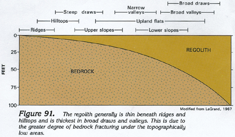
Relation of Regolith Thickness and Topography
Figure 91 Diagram showing that the thickness of the regolith
can be estimated from the topographic setting of a particular
location (168K)
 downloadable tiff file G091.tif.gz (1.2MB
compressed)
downloadable tiff file G091.tif.gz (1.2MB
compressed)
Table 4 Table showing that yields of wells located
in valleys are larger than those of similar wells located on hills
(92K)
 downloadable tiff file Gtab4.tif.gz (548K
compressed)
downloadable tiff file Gtab4.tif.gz (548K
compressed)
 downloadable tiff file G091.tif.gz (1.2MB
compressed)
downloadable tiff file G091.tif.gz (1.2MB
compressed)  downloadable tiff file Gtab4.tif.gz (548K
compressed)
downloadable tiff file Gtab4.tif.gz (548K
compressed)