GROUND WATER ATLAS of the UNITED STATES
Idaho, Oregon, Washington
HA 730-H
Other areas of substantial ground-water development
There are two different files for each illustration
- A 90 ppi JPEG file, suitable for screen viewing is accessed
through the thumbnail image.
- A tiff file is accessed through the "tiff file"
link. All files are Adobe Photoshop. These files have been compressed
with GNU's gzip utility. If your web browser defaults to a screen
display of the file, turn on the "Load to local disk"
option before downloading. Download and process these tiff files
as ascii, not binary.
IDAHO
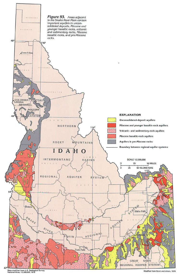
Figure 93 Map showing aquifers adjacent to the Snake
River Plain (252K)
 downloadable tiff
file H093.tif.gz (5.2MB compressed)
downloadable tiff
file H093.tif.gz (5.2MB compressed)
Table 7 Chart showing ground-water conditions
in other areas of substantial ground-water use in Idaho (236K)
 downloadable
tiff file Htab7.tif.gz
(1.5MB compressed)
downloadable
tiff file Htab7.tif.gz
(1.5MB compressed)
OREGON
Figure 94 Map showing aquifers outside of the regional
aquifer systems (344K)
 downloadable tiff
file H094.tif.gz (6.4MB compressed)
downloadable tiff
file H094.tif.gz (6.4MB compressed)
Table 8 Chart showing ground-water conditions
in other areas of substantial ground-water use in Oregon (388K)
 downloadable
tiff file Htab8.tif.gz
(2.7MB compressed)
downloadable
tiff file Htab8.tif.gz
(2.7MB compressed)
WASHINGTON
Figure 95 Map showing aquifers outside of the regional aquifer
systems (188K)
 downloadable tiff
file H095.tif.gz (4.1MB compressed)
downloadable tiff
file H095.tif.gz (4.1MB compressed)
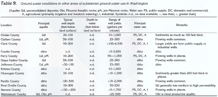
Table 9 Chart showing ground-water conditions
in other areas of substantial ground-water use in Washington (212K)
 downloadable
tiff file Htab9.tif.gz
(1.4MB compressed)
downloadable
tiff file Htab9.tif.gz
(1.4MB compressed)
Return to Other areas of substantial
ground-water development text
Return to HA 730-H table of contents
Return to Ground Water Atlas home page
 downloadable tiff
file H093.tif.gz (5.2MB compressed)
downloadable tiff
file H093.tif.gz (5.2MB compressed)  downloadable
tiff file Htab7.tif.gz
(1.5MB compressed)
downloadable
tiff file Htab7.tif.gz
(1.5MB compressed) 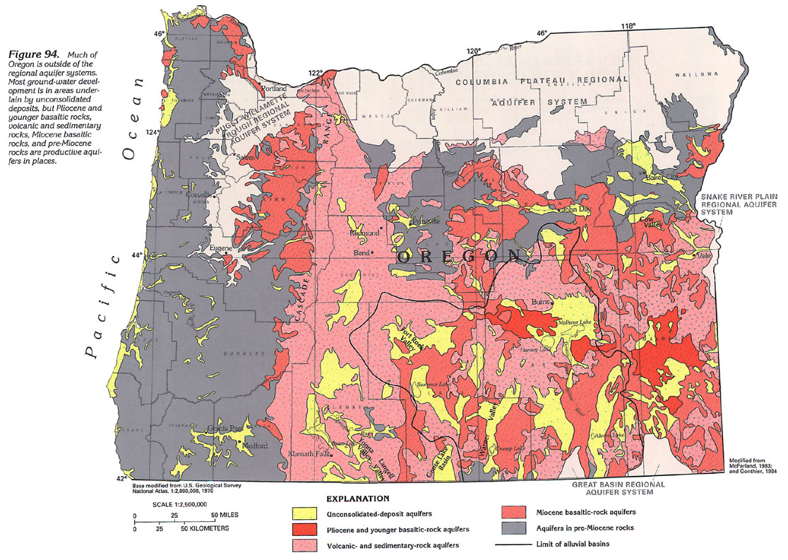 downloadable tiff
file H094.tif.gz (6.4MB compressed)
downloadable tiff
file H094.tif.gz (6.4MB compressed) 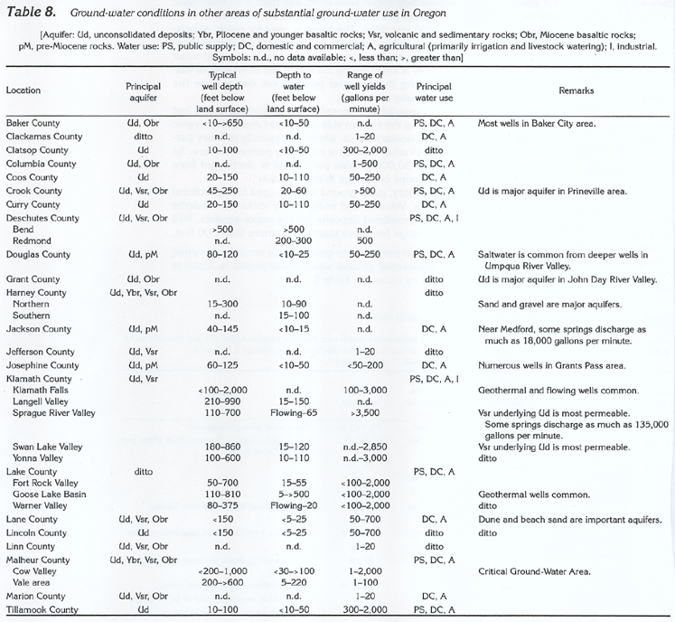 downloadable
tiff file Htab8.tif.gz
(2.7MB compressed)
downloadable
tiff file Htab8.tif.gz
(2.7MB compressed) 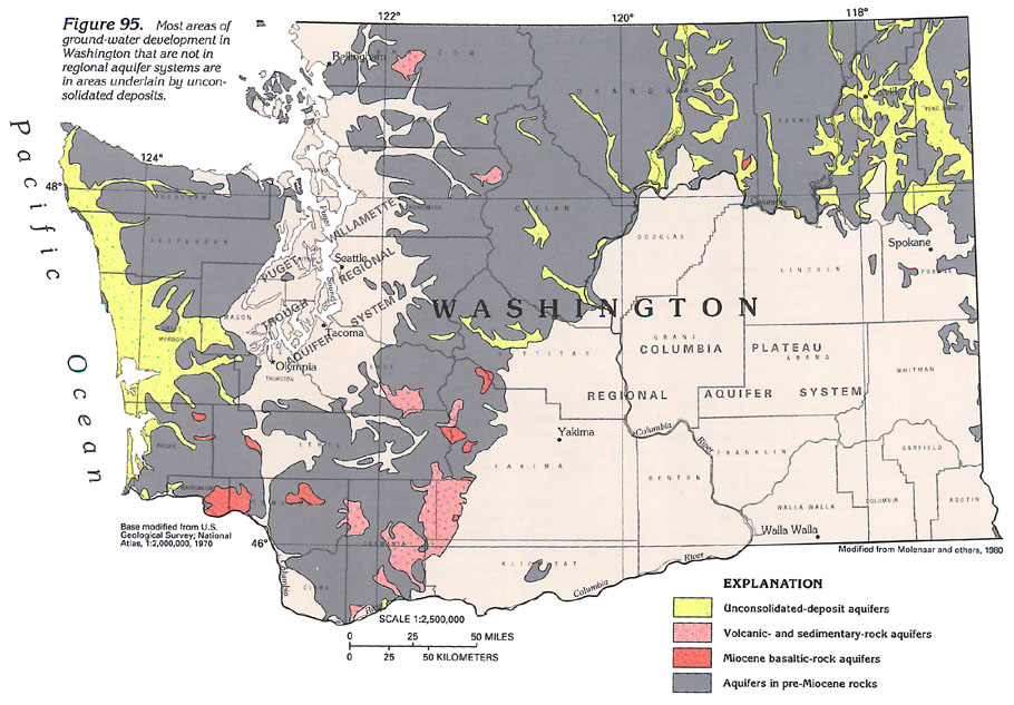 downloadable tiff
file H095.tif.gz (4.1MB compressed)
downloadable tiff
file H095.tif.gz (4.1MB compressed)
 downloadable
tiff file Htab9.tif.gz
(1.4MB compressed)
downloadable
tiff file Htab9.tif.gz
(1.4MB compressed)