Segment 7 contains areas of substantial ground-water development that are not included in any of the regional aquifer systems. Therefore, this section gives a brief overview of ground-water conditions in those areas by State and county. Those counties that are extremely rugged topographically or lack ground-water development are not mentioned in the following discussion.
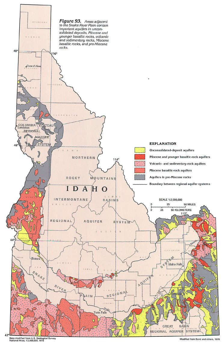
IDAHO
Counties in Idaho (fig. 93) that
contain areas of substantial ground-water development include
Adams and Washington in western Idaho; Twin Falls and Cassia in
south-central Idaho; Power, Bannock, Bingham, Bonneville, and
Caribou in southeastern Idaho; and Clark, Fremont, and Teton in
eastern Idaho. Wells withdraw water from unconsolidated deposits,
Pliocene and younger basaltic rocks, volcanic and sedimentary
rocks, Miocene basaltic rocks, and pre-Miocene rocks. In each
county, the water is used for one or more of the following purposes:
public-supply, domestic and commercial, agricultural, and industrial.
A synopsis of some aspects of the ground-water system in selected
areas of ground-water development in Idaho (fig. 93) is presented below:
· In Adams County, most ground-water development is in
the southern part of the county. Water is withdrawn by shallow
wells that are usually less than 100 feet deep in unconsolidated-deposit
aquifers near streams. Yields are usually less than 100 gallons
per minute. Deeper wells completed in Miocene basaltic-rock aquifers
are the largest yielding wells in the county. Yields of as much
as 600 gallons per minute from these aquifers have been reported.
The volcanic and sedimentary rocks are mostly silt and clay and
are not known to be aquifers here, except where they contain scattered
lenses of sand and gravel. The water is used primarily for domestic
and commercial and agricultural purposes. Depth to water ranges
from flowing to more than 200 feet below land surface.
· Unconsolidated deposits in Washington County contain
a significant percentage of silt and clay. Except for lenses of
sand and gravel, the permeability of these deposits is generally
low; the permeability of the volcanic and sedimentary rocks is
low for the same reasons. Yields of wells in the unconsolidated-deposit
aquifers and the volcanic- and sedimentary-rock aquifers are generally
less than 10 gallons per minute. In contrast, Miocene basaltic-rock
aquifers yield as much as 1,835 gallons per minute to wells. Most
wells range from less than 20 to more than 960 feet deep. Depth
to water ranges from flowing to 80 feet below land surface. The
water is used for public-supply, domestic and commercial, and
agricultural purposes. Geothermal water is common in places.
· Most ground water in Twin Falls County is withdrawn from
Miocene basaltic-rock aquifers and volcanic- and sedimentary-rock
aquifers. The unconsolidated deposits contain a large percentage
of clay, and permeability is low. Wells range from less than 300
to as much as 2,525 feet deep. Water levels range from flowing
to about 80 feet below land surface. Some wells might yield as
much as 2,800 gallons per minute. Water is used for public-supply,
domestic and commercial, and agricultural purposes. Geothermal
water from deep wells and some springs is common in places.
· Wells in Cassia County produce large quantities of water,
as much as 3,000 gallons per minute, from unconsolidated-deposit
and Pliocene and younger basaltic-rock aquifers in the northern
part of the Raft River Valley. In the rest of the valley to the
south, the permeability of the unconsolidated deposits is variable
but overall is low. Parts of the county near Oakley were designated
as Critical Ground-Water Areas by the State in the early 1960's.
Depth to water ranges from flowing to more than 500 feet below
land surface. The central part of the Raft River Valley has been
studied in detail for its geothermal potential. A large quantity
(about 50,000 gallons per minute) of ground water is estimated
to flow out of the valley at its north end to recharge the eastern
Snake River Plain regional aquifer system. Water in the county
is used for public-supply, domestic and commercial, and agricultural
purposes.
· Rockland Valley and Bannock Creek Valley in Power County
are areas where ground water is used primarily for agricultural
purposes and, to a small extent, for domestic and commercial purposes.
Depth to water ranges from flowing to more than 600 feet below
land surface. Yields of wells completed in unconsolidated-deposit
aquifers range from less than 20 to more than 500 gallons per
minute; smaller yields are more common. Miocene basaltic rocks
are aquifers at the north end of Rockland Valley.
· In Bannock and Caribou Counties, ground water is used
for public-supply, domestic and commercial, agricultural, and
industrial purposes; the industrial use is related to mining activities
and food processing. Unconsolidated deposits and Pliocene and
younger and Miocene basaltic rocks are aquifers. The unconsolidated
deposits are typically fine grained and, except for flood-plain
deposits that consist of layers of sand and gravel, permeability
is low. The Pliocene and younger basaltic rocks are extremely
permeable. Depth to water ranges from flowing to more than 200
feet below land surface. Yields of wells range from less than
20 to 3,500 gallons per minute in Caribou County and 5,000 gallons
per minute in Bannock County.
· Ground water is used in Bingham and Bonneville Counties
for domestic and commercial and agricultural purposes. Most development
is near the Snake River in areas of unconsolidated deposits or
in upland areas in Pliocene and younger basaltic or volcanic and
sedimentary rocks. Depth to water ranges from flowing to more
than 100 feet below land surface. Yields are typically low; however,
one well that was completed in unconsolidated deposits and basaltic
rocks in Bonneville County was reported to yield as much as 1,800
gallons per minute.
· In Madison County, Pliocene and younger basaltic-rock
and volcanic- and sedimentary-rock aquifers yield small amounts
of water to wells in upland areas. However, most ground-water
development is near the Snake River where wells are completed
in unconsolidated deposits. Yields range from less than 10 to
75 gallons per minute. The water is used for domestic and commercial
and agricultural (primarily livestock watering) purposes.
· The Teton Valley in Teton County is a broad, alluvium-filled
valley that has substantial agricultural development. Coarse-grained
unconsolidated deposits on the east side of the valley yield far
more water to wells than do the fine-grained deposits on the west
side. Some wells yield as much as 800 gallons per minute. Most
of the water used for public-supply, domestic and commercial,
and agricultural purposes is withdrawn by wells completed in unconsolidated-deposit
aquifers and, in part, from wells completed in Pliocene and younger
basaltic-rock aquifers at the northern end of the valley. Depth
to water ranges from less than 5 to more than 100 feet below land
surface and increases near the valley margins.
· In Fremont County, most of the demand for ground water
is near Henrys Fork. Aquifers in unconsolidated deposits, Pliocene
and younger basaltic rocks, and volcanic and sedimentary rocks
yield from less than 5 to more than 800 gallons per minute to
wells that are about 10 to more than 400 feet deep. The water
is used for public-supply, domestic and commercial, and agricultural
(primarily livestock watering) purposes. Demand on the ground-water
resources is small during the winter, but thousands of visitors
during the summer put a great demand on the ground-water resources.
The unconsolidated deposits are as much as 3,600 feet thick along
the eastern side of Henrys Lake. The volcanic and sedimentary
rocks, which are typically not very permeable in other areas,
are extremely permeable here. As much as 90,000 gallons per minute
is discharged from some groups of springs in these rocks.
· In Clark County, most ground water is used for agricultural
purposes. Volcanic and sedimentary rocks that underlie the unconsolidated
deposits are the major aquifers. Well depths range from less than
100 to more than 500 feet.
Information pertaining to ground-water conditions in other
areas of substantial ground-water development in Idaho is summarized
by county in table 7.
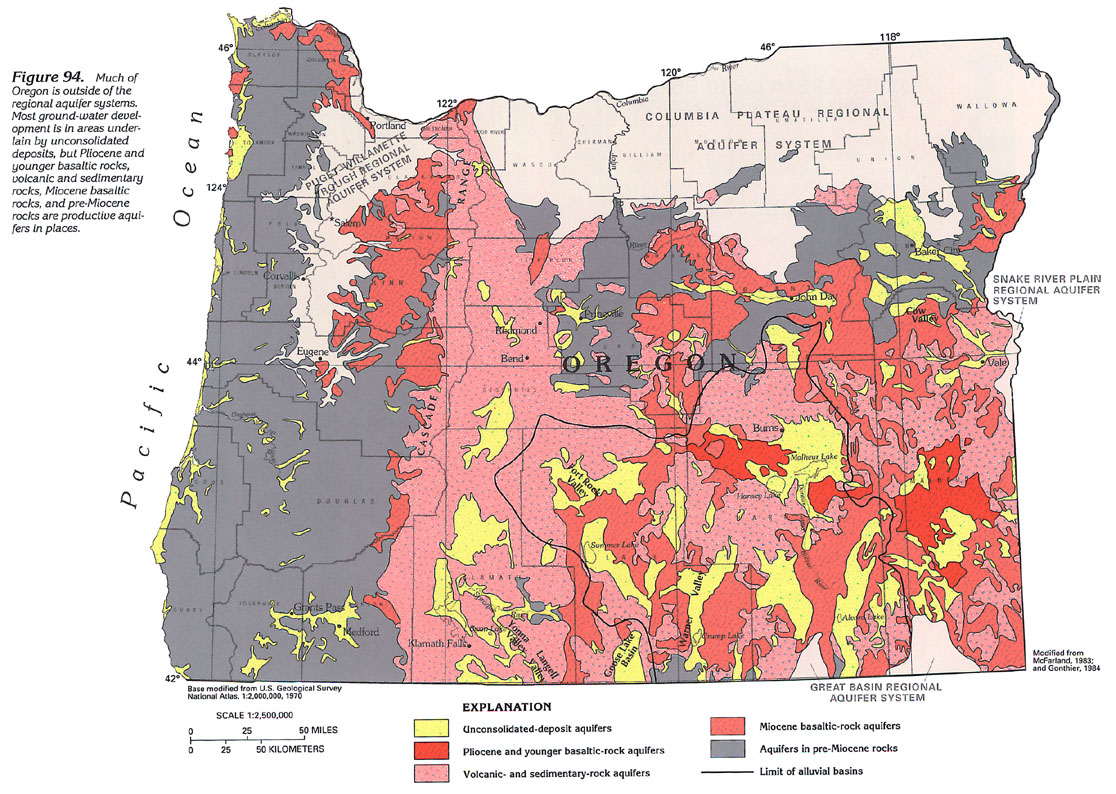
OREGON
A substantial amount of ground-water development occurs throughout
Oregon in areas that are not included as part of the regional
aquifer systems (fig. 94).
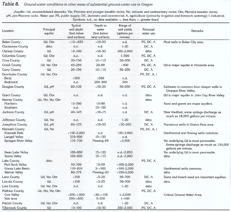
Counties west of the Cascade Range are, for the most part, topographically rugged and have little or no ground-water development. However, unconsolidated deposits in stream valleys provide substantial quantities of water to wells for public-supply, domestic and commercial, agricultural, and industrial purposes. Miocene basaltic rocks are aquifers in Clatsop, Lane, Linn, and Marion Counties. Volcanic and sedimentary rocks along the crest of the Cascade Range are extremely permeable and transmit recharge from rainfall and snowmelt to underlying aquifers. There are only a few wells along the crest of the Cascade Range. Along the Oregon coast, virtually all communities obtain water from unconsolidated-deposit aquifers. An exception is along the Umpqua River Valley in Douglas County, where aquifers in underlying pre-Miocene rocks supply some water to wells. Unconsolidated deposits and volcanic and sedimentary rocks in the north-central part of Oregon east of the Cascade Range are used extensively as aquifers in Deschutes County and, to a much smaller degree, in Crook and Jefferson Counties. Miocene basaltic rocks are important aquifers in places in Crook and Grant Counties. In south-central Oregon, chiefly in Klamath and Lake Counties, the volcanic and sedimentary rocks are extremely permeable in places, and large quantities of water are withdrawn by wells for public-supply, domestic and commercial, agricultural, and industrial purposes. Underlying Miocene basaltic rocks are important aquifers in places. Klamath Falls in Klamath County has developed geothermal water in volcanic- and sedimentary rock aquifers into a system for heating homes and public buildings.
In Baker, Harney, and Malheur Counties, ground water is withdrawn by wells completed in unconsolidated deposits, Pliocene and younger basaltic rocks, volcanic and sedimentary rocks, and Miocene basaltic rocks.
The alluvial basins, chiefly in Lake and Harney Counties, are closed basins from which no water flows. All water that leaves the closed basins does so only as evapotranspiration.
A synopsis of the ground-water system in other areas of substantial
ground-water development in Oregon (fig. 94) is presented below:
· Along and near the Oregon coast, virtually all communities
obtain water from unconsolidated-deposit aquifers. Two exceptions
are along the Columbia River in Columbia County, where Miocene
basaltic rocks are aquifers, and along the Umpqua River in Douglas
County, where aquifers in pre-Miocene rocks that underlie the
unconsolidated deposits supply some water to wells.
In Lane and Lincoln Counties, dune and beach sand are major aquifers.
Most wells that have been completed in the unconsolidated-deposit
aquifers generally are less than 150 feet deep. The deepest wells
in the unconsolidated-deposit aquifers are in Coos and Curry Counties;
the shallowest wells, which are generally about 10 feet deep,
are predominantly in Clatsop and Tillamook Counties. Depth to
water in wells ranges from less than 5 feet below land surface
in Lane and Lincoln Counties to 110 feet below land surface in
the deep wells in Coos and Curry Counties.
The unconsolidated-deposit aquifers are productive. Well yields
generally range from 50 to 250 gallons per minute in Coos, Curry,
and Douglas Counties; from 50 to 700 gallons per minute in Lane
and Lincoln Counties; and from 300 to about 2,000 gallons per
minute in Clatsop and Tillamook Counties. Most fresh ground-water
withdrawals are used for domestic and commercial and agricultural
(primarily livestock watering) purposes. Deeper wells along the
Umpqua River Valley in Douglas County commonly yield saltwater.
The potential for saltwater intrusion into freshwater aquifers
exists along the entire coast.
· Other areas of substantial ground-water development in
Oregon are west-central Jackson and east-central Jo-sephine Counties.
In west-central Jackson County, unconsolidated deposits and pre-Miocene
rocks are major aquifers. In the Medford area of Jackson County,
springs discharge as much as 18,000 gallons per minute. Wells
that are used for domestic and commercial and agricultural (primarily
livestock watering) purposes generally
are 40 to 145 feet deep. Depth to water ranges from less than
10 to about 15 feet below land surface.
In east-central Josephine County, unconsolidated deposits and
pre-Miocene rocks are the major aquifers. In the Grants Pass area,
wells that are used for domestic and commercial and agricultural
(primarily livestock watering) purposes generally are 60 to 125
feet deep. Depth to water ranges from less than 10 to 50 feet
below land surface. Yields from these wells range from less than
50 to 200 gallons per minute.
· In Jefferson County in north-central Oregon, ground water
is obtained from unconsolidated deposits and volcanic and sedimentary
rocks. The water is used for domestic and commercial and agricultural
purposes. Well yields are generally small.
· Some of the most productive aquifers in Oregon are volcanic-
and sedimentary-rock aquifers that consist of porous basalt and
cinders and that underlie the Sprague River Valley in south-central
Klamath County. In this valley, some wells that generally range
from 100 to 700 feet in depth yield about 3,500 gallons per minute
with only a few feet of drawdown. Artesian wells might flow at
a rate of 1,000 gallons per minute and can be pumped at rates
that exceed 2,000 gallons per minute. The maximum depth to water
in nonflowing wells is about 65 feet below land surface. Large
springs also are present in the valley and discharge from 39,000
to 135,000 gallons per minute, depending on the volume of recharge.
South of Sprague River Valley, Swan Lake, Yonna, and Langell Valleys
are filled with fine-grained unconsolidated deposits that yield
little water, but the underlying volcanic- and sedimentary-rock
aquifers yield large quantities of water to wells; maximum well
yields in Swan Lake Valley are about 2,850 gallons per minute,
and those in Yonna Valley are about 3,000 gallons per minute.
Well depth in the valleys varies-from 180 to 860 feet in Swan
Lake Valley, from 100 to 600 feet in Yonna Valley, and from 210
to 990 feet in Langell Valley; however, depth to water in the
wells is similar-from 15 to 120 feet below land surface in Swan
Lake Valley, from 10 to 110 feet below land surface in Yonna Valley,
and from 15 to 150 feet below land surface in Langell Valley.
Fresh ground-water withdrawals in all four valleys are used mostly
for agricultural (primarily irrigation and livestock watering)
purposes. In the Klamath Falls area, wells that are as much as
2,000 feet deep yield geothermal water from volcanic- and sedimentary-rock
aquifers. As many as 500 wells supply geothermal water for heating
homes and public buildings in Klamath Falls. Well yields in the
Klamath Falls area generally range from 100 to 3,000 gallons per
minute.
· In southwestern Lake County, Goose Lake Basin is filled
with unconsolidated deposits, some of which contain organic debris.
Decay of the organic debris results in ground water that contains
large concentrations of iron, hydrogen sulfide, and methane. However,
most wells that generally are from 110 to 810 feet deep are completed
in the underlying volcanic- and sedimentary-rock aquifers and
do not contain large concentrations of iron, hydrogen sulfide,
and methane. Some of these deeper wells yield geothermal water.
· The upper John Day River Valley in Grant County in north-central
Oregon is long and narrow (less than 1 mile wide) and is bordered
by steep rock walls. Unconsolidated deposits that fill the valley
are coarse and extremely permeable. Near the town of John Day,
the Miocene basaltic rocks that underlie the unconsolidated deposits
are much less permeable. The water is used for domestic and commercial
and agricultural purposes.
· Near Bend in Deschutes County, ground water is obtained
from volcanic and sedimentary rocks that consist of basalt flows,
cinders, ash, and pumice. Depth to water normally exceeds 500
feet below land surface; domestic wells generally are not drilled
to this depth. Northwestward from Bend toward Redmond, depth to
water decreases and ranges from 200 to 300 feet below land surface,
which slopes northward. Well yields of as much as 500 gallons
per minute are common near Redmond.
· In Baker City, Baker County, the water table ranges from
less than 10 to 50 feet below land surface. Shallow wells yield
water from unconsolidated-deposit aquifers; deeper wells yield
water from Miocene basaltic-rock aquifers for public-supply, domestic
and commercial, and agricultural purposes. The wells range in
depth from about 10 to more than 650 feet.
· Cow Valley in northern Malheur County is a small upland
basin that was declared a Critical Ground-Water Area during 1959.
Wells in the valley yield water from unconsolidated deposits (primarily
sand and gravel) and from Miocene basaltic rocks that are at various
depths; for example, some wells that are less than 500 feet deep
are completed in basaltic rocks, whereas nearby wells that are
as much as 1,000 feet deep might be completed in sand and gravel.
The water is used mostly for agricultural purposes. Unconsolidated
deposits in the Vale area southeast of Cow Valley are the primary
source of ground water that is used for public-supply, domestic
and commercial, and agricultural purposes. Well depths range from
200 to more than 600 feet. Depth to water ranges from about 5
feet to 220 feet below land surface.
· In south-central Oregon, alluvial basins, which are characterized
by semiarid environments, are underlain primarily by unconsolidated-deposit,
Pliocene and younger basaltic-rock, volcanic- and sedimentary-rock,
and Miocene basaltic-rock aquifers and occupy most of Harney and
Lake Counties. Most recharge to aquifers originates from winter
snowfall or summer rainstorms, and most discharge is by evapotranspiration
and, in developed areas, by ground-water withdrawals. Typically,
the alluvial basins are closed; that is, virtually all surface
water and ground water that enters the basins flows or discharges
into lakes, ponds, or marshes that occupy the centers of the basins
where the water is evaporated or transpired by plants. Dissolved
minerals in the surface and the ground water are concentrated
by evaporation, which results in saltwater lakes, ponds, and marshes,
and salty ground water at shallow depths in the ponding areas.
Some minerals precipitate from solution and form deposits on the
land surface.
· Several communities in Harney and Lake Counties obtain
their water supply from streams that are sustained by spring flow;
for example, flow in the Donner Und Blitzen River, which is sustained
by generally constant discharge from several large springs, provides
a dependable water supply for Burns in Harney County. In northern
Harney County, unconsolidated-deposit aquifers, which consist
of sand and gravel, are the major source of water; Miocene basaltic-rock
aquifers also provide some water. Well depths generally range
from 15 to 300 feet. Depth to water generally is from 10 to 90
feet below land surface. Fresh ground water is used for public-supply,
domestic and commercial, and agricultural (primarily livestock
watering), purposes. Salty ground water is present near Harney
and Malheur Lakes. In southern Harney County, unconsolidated deposits
and volcanic and sedimentary rocks are major aquifers. Depth to
water generally is from 15 to 100 feet below land surface. Fresh
ground water is used for the same purposes as in northern Harney
County. In southern Harney County, salty ground water is present
near Alvord Lake and in much of the basin northeast of the lake.
· In Lake County, unconsolidated deposits and volcanic
and sedimentary rocks are major aquifers. Well yields might be
as much as 2,000 gallons per minute. In Fort Rock Valley (northwestern
Lake County), well depths generally range from 50 to 700 feet.
Depth to water generally is 15 to 55 feet below land surface.
In the Goose Lake Basin, well depths exceed 800 feet. Depth to
water can be more than 500 feet below land surface. In Warner
Valley (southeastern Lake County), well depths generally range
from 80 to 375 feet. Some of the deeper wells, which are completed
in volcanic- and sedimentary-rock aquifers, are geothermal and
flow at land surface. Depth to water in nonflowing wells in Warner
Valley generally is about 20 feet below land surface. Fresh ground
water in Lake County is used for public-supply, domestic and commercial,
and agricultural (primarily irrigation and livestock watering)
purposes. Salty ground water is present near Crump and Summer
Lakes.
Information pertaining to ground-water conditions in other
areas of substantial ground-water development in Oregon is summarized
by county in table 8.
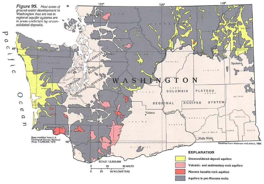
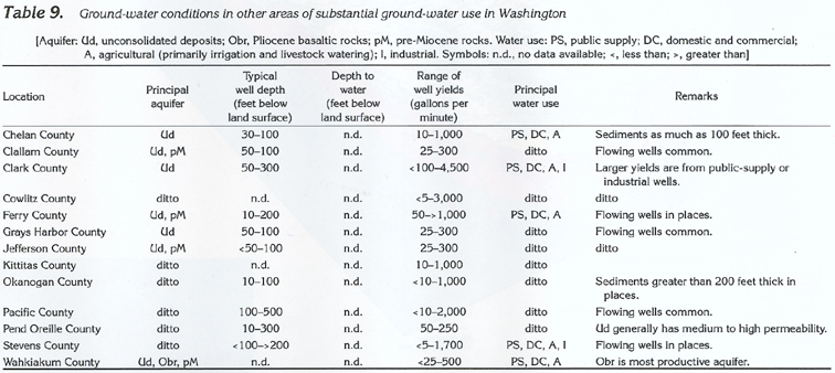
WASHINGTON
Other areas of substantial ground-water development in Washington
that are not in the regional aquifer systems include Ferry, Okanogan,
Pend Oreille, and Stevens Counties in northeastern Washington
(fig. 95); Chelan and Kittitas Counties
in central Washington; Clallam, Grays Harbor, Jefferson, and Pacific
Counties along the Washington coast; and Wahkiakum County along
the Columbia River near the Washington coast. Unconsolidated deposits
are the most important aquifers. They provide water for public-supply,
domestic and commercial, agricultural, and industrial purposes.
Much of each of the above counties is topographically rugged, and ground-water development is in the valleys or terraces. Aquifers in Miocene basaltic and pre-Miocene rocks locally yield small quantities of water to wells.
A synopsis of some aspects of the ground-water system in selected
areas of substantial ground-water development in Washington (fig. 95) is presented below:
· The river valleys in Ferry, Pend Oreille, and Stevens
Counties are filled with alluvium and glacial deposits that compose
the unconsolidated-deposit aquifers. Ground water is used for
domestic and commercial and agricultural purposes. Most wells,
which range from less than 100 to 200 feet deep, yield from 50
to 250 gallons per minute. A few deeper wells yield from 250 to
as much as 1,700 gallons per minute. An artesian municipal well
for Colville in Stevens County yields as much as 1,700 gallons
per minute.
· Glacial deposits of sand and gravel as much as several
hundred feet thick are major aquifers in the Okanogan River Valley
in Okanogan County. The greatest use of ground water is for agricultural
(irrigation and livestock watering) purposes, but some is used
for public-supply and domestic and commercial purposes. Wells
that are less than 60 feet deep yield from less than 10 to 1,000
gallons per minute in most places.
· In Chelan and Kittitas Counties, unconsolidated deposits
are major aquifers; some deposits are as much as 100 feet thick.
Most wells, which range from 30 to 100 feet deep, withdraw water
for public-supply, domestic and commercial, and agricultural (primarily
livestock watering) purposes. Yields to wells range from 10 to
1,000 gallons per minute.
· Along the Washington coast, virtually all wells yield
water from unconsolidated-deposit aquifers. In Clallam, Grays
Harbor, and Jefferson Counties, the depth of wells, which generally
ranges from 50 to 100 feet, is similar, as is the yield, which
ranges from 25 to 300 gallons per minute. In Pacific County, wells
tend to be deeper (100 to 500 feet) and yield more water (50 to
2,000 gallons per minute). Artesian wells are common. Dune and
beach sand are aquifers in places. In all four counties, the principal
uses of fresh ground-water withdrawals are for public-supply,
domestic and commercial, and agricultural (primarily irrigation
and livestock watering) purposes; fresh ground-water withdrawals
also are used for industrial purposes in Pacific County. As along
the Oregon coast, the potential for saltwater intrusion into freshwater
aquifers exists.
· Along the Columbia River in Wahkiakum County, wells produce
water from unconsolidated-deposit aquifers in the lowlands and
from Miocene basaltic-rock aquifers in the uplands. Wells completed
in the unconsolidated deposits yield from 25 to 250 gallons per
minute. Wells completed in the Miocene basaltic rocks yield from
50 to 500 gallons per minute. Most freshwater withdrawn is used
for domestic and commercial and agricultural (primarily livestock
watering) purposes.
Information pertaining to ground-water conditions in other areas of substantial ground-water development in Washington is summarized by county in table 9.