GROUND WATER ATLAS of the UNITED STATES
Idaho, Oregon, Washington
HA 730-H
Regional summary
There are two different files for each illustration
- A 90 ppi JPEG file, suitable for screen viewing is accessed
through the thumbnail image
- A tiff file is accessed through the "tiff file"
link. All files are Adobe Photoshop. These files have been compressed
with GNU's gzip utility. If your web browser defaults to a screen
display of the file, turn on the "Load to local disk"
option before downloading. Download and process these tiff files
as ascii, not binary.
Areal Distribution of Aquifers
Figure 5 Map showing aquifers in segment 7 (848K)
 downloadable
tiff file H005.tif.gz (23.7MB
compressed)
downloadable
tiff file H005.tif.gz (23.7MB
compressed)
Structural Basins and Aquifers
Figure 6 Cross section showing structural basins in
Washington (204K)
 downloadable
tiff file H006.tif.gz (1.6MB
compressed)
downloadable
tiff file H006.tif.gz (1.6MB
compressed)
Figure 7 Cross section showing synclinal basin in eastern
Oregon (92K)
 downloadable
tiff file H007.tif.gz (564K
compressed)
downloadable
tiff file H007.tif.gz (564K
compressed)
Figure 8 Cross section of Basin and Range in south-central
Oregon showing major faultlines (188K)
 downloadable
tiff file H008.tif.gz (1.1MB
compressed)
downloadable
tiff file H008.tif.gz (1.1MB
compressed)
Figure 9 Cross section of unconsolidated basaltic rock
in the Snake River Plain aquifer (84K)
 downloadable
tiff file H009.tif.gz (504K
compressed)
downloadable
tiff file H009.tif.gz (504K
compressed)
Figure 10 Cross section of unconsolidated-deposit aquifers
in the Snake River Plain (252K)
 downloadable
tiff file H010.tif.gz (1.7MB
compressed)
downloadable
tiff file H010.tif.gz (1.7MB
compressed)
 downloadable
tiff file H005.tif.gz (23.7MB
compressed)
downloadable
tiff file H005.tif.gz (23.7MB
compressed) 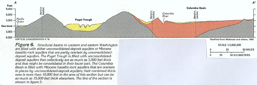 downloadable
tiff file H006.tif.gz (1.6MB
compressed)
downloadable
tiff file H006.tif.gz (1.6MB
compressed) 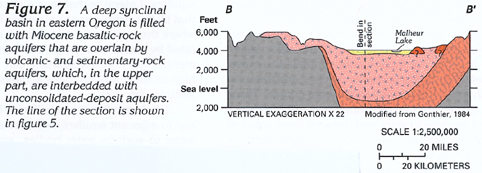 downloadable
tiff file H007.tif.gz (564K
compressed)
downloadable
tiff file H007.tif.gz (564K
compressed) 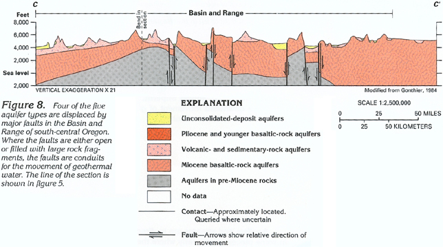 downloadable
tiff file H008.tif.gz (1.1MB
compressed)
downloadable
tiff file H008.tif.gz (1.1MB
compressed) 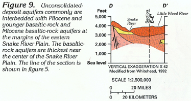 downloadable
tiff file H009.tif.gz (504K
compressed)
downloadable
tiff file H009.tif.gz (504K
compressed)  downloadable
tiff file H010.tif.gz (1.7MB
compressed)
downloadable
tiff file H010.tif.gz (1.7MB
compressed)