
INTRODUCTION
The States of Idaho, Oregon, and Washington, which total 248,730 square miles, compose Segment 7 of this Atlas. The area is geologically and topographically diverse and contains a wealth of scenic beauty, natural resources, and ground and surface water that generally are suitable for all uses. Most of the area of Segment 7 is drained by the Columbia River, its tributaries, and other streams that discharge to the Pacific Ocean. Exceptions are those streams that flow to closed basins in southeastern Oregon and northern Nevada and to the Great Salt Lake in northern Utah. The Columbia River is one of the largest rivers in the Nation. The downstream reach of the Columbia River forms most of the border between Oregon and Washington. In 1990, Idaho, Oregon, and Washington had populations of 1.0 million, 2.8 million, and 4.9 million, respectively. The more densely populated parts are in lowland areas and stream valleys. Many of the mountains, the deserts, and the upland areas of Idaho, Oregon, and Washington lack major population centers. Large areas of Idaho and Oregon are uninhabited and are mostly public land (fig. 1) where extensive ground-water development is restricted.
Surface water is abundant in Idaho, Oregon, and Washington, though not always available when and where needed. In some places, surface water provides much of the water used for public-supply, domestic and commercial, agricultural (primarily irrigation and livestock watering), and industrial purposes. In arid parts of Segment 7, however, surface water has long been fully appropriated, chiefly for irrigation. Ground water is used when and where surface-water supplies are lacking.
Ground water is commonly available to shallow wells that are completed in unconsolidated-deposit aquifers that consist primarily of sand and gravel but contain variable quantities of clay and silt. Many large-yield public-supply and irrigation wells and thousands of domestic wells are completed in these types of aquifers, generally in areas of privately owned land (fig. 1). In many places, deeper wells produce water from underlying volcanic rocks, usually basalt.
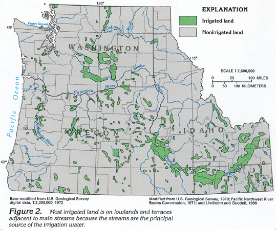
Most irrigation (fig. 2) is on lowlands next to streams and on adjacent terraces. Generally, lowlands within a few miles of a main stream are irrigated with surface water diverted by gravity flow from the main stream or a reservoir and distributed through a system of canals and ditches. In some areas, water is pumped to irrigate lands farther from the stream at a higher altitude. Along the Snake and Columbia Rivers, large pumping systems withdraw billions of gallons of water per day from the rivers to irrigate adjacent uplands that are more than 500 feet higher than the rivers. Elsewhere, irrigation water is obtained from large-capacity wells, where depth to water might exceed 500 feet below land surface.
Aquifers in Idaho, Oregon, and Washington, as in most other States, differ considerably in thickness and permeability, and well yields differ accordingly. Ground-water levels in a few areas have declined as a result of withdrawals by wells. State governments have taken steps to alleviate declines in some areas by enacting programs that either limit the number of additional wells that can be completed in a particular aquifer (Ground-Water Management Area) or prevent further ground-water development (Critical Ground-Water Area).
Segment 7 includes some of the driest parts of the Nation, as well as some of the wettest. Average annual precipitation (1951-80) ranges from less than 10 inches in arid parts of Idaho, Oregon, and Washington to more than 80 inches in the western parts of Oregon and Washington (fig. 3). Most storms generally move eastward through the area. The eastward-moving air absorbs the moisture that evaporates from the Pacific Ocean. As this air encounters the fronts of mountain ranges, it rises, cools, and condenses. Accordingly, the western sides of the mountain ranges receive the most precipitation. Much of the annual precipitation moves directly to streams as overland runoff. Some of the precipitation is returned to the atmosphere by evapotranspiration, which is the combination of evaporation from the surface and transpiration from the plants. A small part of the precipitation infiltrates the soil and percolates downward to recharge underlying aquifers.
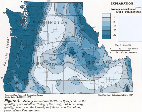
Average annual runoff (1951-80) in the segment varies considerably (fig. 4), and the distribution of the runoff generally parallels that of precipitation. In the arid and the semiarid parts of Segment 7, most precipitation replenishes soil moisture, evaporates, or is transpired by vegetation. Little is left to maintain streamflow or to recharge aquifers. In the wetter parts, much of the precipitation runs off the land surface to maintain streamflow, and because evaporation is usually less in wetter areas, more water is available to recharge aquifers. Precipitation that falls as snow generally does not become runoff until spring thaws begin. Reservoirs constructed on major streams to mitigate flooding and to store water for irrigation, hydroelectric-power generation, and recreation also affect the timing of runoff. The runoff is stored and subsequently released during drier periods to maintain downstream flow.
AREAL DISTRIBUTION
OF AQUIFERS
All aquifers in Segment 7 were assigned to one of five general types (fig. 5) depending on their geologic and hydrologic characteristics. Three of the aquifer types generally consist of one kind of rock; the other two types of aquifers, however, consist of two or more different kinds of rocks.
Of the five types, the most prolific aquifers are those in unconsolidated deposits that consist primarily of alluvial sand and gravel that fill large to small basins in all three States in Segment 7. These aquifers are important sources of water for public-supply, domestic and commercial, agricultural, and industrial needs because of their location in generally flat lowlands where human activities are concentrated. Some of these aquifers in southern Oregon and Idaho are part of an extensive group of basin-fill aquifers that extend southward, and are called the Basin and Range aquifers. These aquifers are described in segments 1 and 2 of this Atlas.
Aquifers in Pliocene and younger basaltic rocks characterize the Snake River Plain of southern Idaho and southeastern Oregon. Numerous extensive flows of basaltic lava have spread out from vents in and near the Snake River Plain. Permeable zones at the tops and the bottoms of these flows yield large volumes of water to irrigation wells. These aquifers also discharge about 1 million gallons per day to springs in the walls of the Snake River Canyon.
Although aquifers in undifferentiated volcanic and sedimentary rocks are present in all three States, they are found primarily in southern Idaho and Oregon. These undifferentiated rocks include beds of volcanic ash and tuff, basalt, silicic volcanic rocks, and semiconsolidated to consolidated sedimentary rocks that contain small to large quantities of volcanic material. The rocks are complexly interbedded, and their permeability is extremely variable.
Aquifers in Miocene basaltic rocks are important chiefly in the Columbia Plateau area of northeastern Oregon and southeastern Washington. These aquifers consist primarily of numerous extensive flows of basaltic lava that have spread out from fissures in many areas. Permeable zones, which are like those in the flows of the Snake River Plain, are at the tops and the bottoms of these lava flows. Wells that are deep enough to penetrate several of these permeable zones yield large volumes of water. Water from these aquifers is used primarily for irrigation.
Aquifers in pre-Miocene rocks are widely distributed but are most widespread in much of Idaho, northern Washington, and along the coasts of Oregon and Washington. The rocks composing these aquifers are extremely variable and include several types of igneous and metamorphic rocks, consolidated sedimentary rocks of marine and nonmarine origin, and volcanic rocks. Accordingly, the permeability of these aquifers varies greatly. The aquifers in pre-Miocene rocks are present mostly in mountainous areas, and water from wells completed in these aquifers is used mostly for domestic and agricultural (livestock watering) supplies.
Some aquifers in Segment 7 are parts of regional aquifer systems that have an areal extent of thousands to tens of thousands of square miles. An aquifer system consists of two or more aquifers that are hydraulically connected and that function as a single aquifer system. The regional aquifer systems in Segment 7 (fig. 5) supply varying volumes of freshwater to wells for multiple uses.
Three of the regional aquifer systems shown in figure 5 have been studied under the U.S. Geological Survey's Regional Aquifer-System Analysis (RASA) Program as of 1993. Studies of two additional aquifer systems, the Puget-Willamette Trough and the Northern Rocky Mountains intermontane basins, were under way but not completed as of 1993. The objectives of each RASA study are to describe the ground-water-flow system under natural (undeveloped) conditions and as it exists today, to analyze changes in the system, to integrate the results of previous hydrogeologic studies of the system, and to provide the ability to evaluate the effects of future ground-water development on the system. The three aquifer systems that have been studied are the Great Basin, the Snake River Plain, and the Columbia Plateau. The Basin and Range aquifers in Segment 7 coincide with part of the Great Basin aquifer system, the rest of which is in Segments 1 and 2 of this Atlas; the Snake River Plain and the Columbia Plateau aquifer systems are entirely within Segment 7.
There are two general types of regional aquifer systems. One type consists of an extensive set of aquifers and confining units that might locally be discontinuous but that function hydrologically as a single aquifer system on a regional scale. In Segment 7, the Snake River Plain, the Columbia Plateau, and the Puget-Willamette Trough aquifer systems are examples of this type. The second type consists of a set of virtually independent aquifers that share common hydrologic characteristics. In this type of aquifer system, common hydrologic factors and principles control the occurrence, the movement, and the quality of ground water; accordingly, the study of a few representative aquifers provides understanding of the aquifer system. The Great Basin and the Northern Rocky Mountains intermontane basins aquifer systems in Segment 7 are examples of this type.
STRUCTURAL BASINS AND AQUIFERS
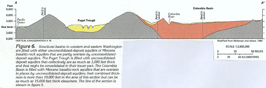
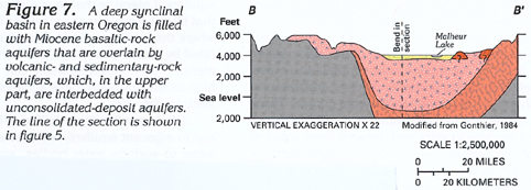
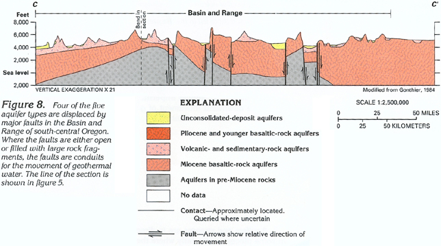
Thick sequences of unconsolidated deposits and volcanic rocks compose the major aquifers that occupy large structural basins in Segment 7 (figs. 6, 7, 8, 9, 10).
Some of these basins are synclines, such as the ones shown in figures 6 and 7. In the Basin and Range area, faults that extend to great depths bound alternating upthrown and downthrown blocks of the Earth's crust (fig. 8). The downthrown blocks, or grabens, have been partially filled with alluvium derived from bedrock hills of the upthrown blocks, or horsts, that separate the grabens. Some faults between these horsts and grabens either are open conduits or are filled with large rock fragments. Ground water that has circulated to great depths and has become heated can move upward along these faults as geothermal water. Other faults, which are filled with extremely small rock fragments, are barriers to ground water movement.
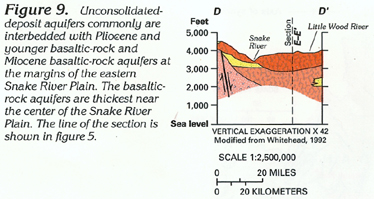
Complex interbedding of unconsolidated deposits and volcanic rocks exists in some places, especially in areas where numerous episodes of volcanic activity have taken place. One such area is the Snake River Plain in Idaho (figs. 9 and 10). This geologic complexity is reflected by a complex groundwater-flow system.
GEOLOGY
The rocks and unconsolidated deposits in Idaho, Oregon, and Washington range in age from pre-Tertiary to Holocene (fig. 11). Small outcrops of rocks younger or older than those shown in figure 11 are present locally but are not shown because of the map scale.
Unconsolidated deposits extend over large areas in Segment 7 and differ considerably in age and grain size. They consist of younger, coarse-grained deposits of chiefly stream or glacial origin and older, fine-grained deposits of chiefly lake, volcanic, or eolian (wind blown) origin. In places, older unconsolidated deposits contain thick beds of volcanic ash; in other places, these deposits contain thin (a few feet to a few tens of feet) flows of basaltic or silicic volcanic rocks. Older unconsolidated deposits usually become increasingly compacted with depth. In southwestern Idaho and southeastern Oregon, older unconsolidated deposits are difficult to distinguish from silicic volcanic rocks where the latter are present as thick beds of ash. Except for eolian deposits in eastern Washington and adjacent Idaho, where these deposits generally are not even partially saturated, the unconsolidated deposits form the unconsolidated-deposit aquifers. In eastern Washington and adjacent Idaho, underlying Miocene basaltic rock forms the major aquifers-Miocene basaltic-rock aquifers (compare fig. 11 with fig. 5).
Volcanic rocks range in composition from basaltic rocks that are dense, fine grained, dark colored, and contain large quantities of iron and manganese to silicic volcanic rocks that generally are coarse grained, light colored, and contain large quantities of silica. Some basalt flows on the Snake River Plain in Idaho are less than 2,000 years old, as are some in the Cascade Range in Oregon and Washington. The latest volcanism was the 1980 eruption of Mount St. Helens in south-central Washington.
Pliocene and younger basaltic rocks are present chiefly in the Snake River Plain in Idaho and underlie much of the Cascade Range in Oregon. Pliocene and younger basaltic rocks are chiefly flows but, in many places in the Cascade Range, the rocks contain thick interbeds of basaltic ash, as well as sand and gravel beds deposited by streams. These flows and associated interbeds form the Pliocene and younger basaltic-rock aquifers.
Silicic volcanic rocks are present chiefly in southwestern Idaho and southeastern Oregon where they consist of thick flows interspersed with unconsolidated deposits of volcanic ash and sand. Silicic volcanic rocks also are the host rock for much of the geothermal water in Idaho and Oregon. In this chapter, these rocks are combined with some unconsolidated deposits and some Pliocene and younger basaltic rocks; this combination of rocks and deposits is referred to as the volcanic- and sedimentary-rock aquifers. The Pliocene and younger basaltic rocks included in these aquifers are those along the Cascade Range and in the adjacent eastern lowland in Oregon and Washington (compare fig. 11 with fig. 5). These rocks are included in the aquifers because (1) they are seldom used as a source of water except locally in lowland areas, and (2) previous investigators have grouped these rocks with the silicic volcanic rocks and some unconsolidated sedimentary rocks on the basis of similar hydrologic characteristics and the hydraulic connection among the rocks.
Miocene basaltic rocks commonly are thick, solid flows that are widespread in southwestern Idaho, eastern Oregon, and south-central Washington. These flows form the Miocene basaltic-rock aquifers.
The undifferentiated volcanic rocks, which are present in all three States, are a heterogeneous mixture that ranges from basaltic to rhyolitic in composition and commonly are thick flows. These rocks can be similar to some younger volcanic rocks but usually are more dense and contain few fractures. These rocks form some of the aquifers in pre-Miocene rocks.
Undifferentiated consolidated sedimentary rocks, which are present primarily in western Oregon and southwestern Washington, consist chiefly of limestone, dolomite, sandstone, and shale. Because some of these rocks were deposited in a marine environment, they might contain saltwater, particularly west of the Cascade Range in Oregon and Washington. These rocks also form some of the aquifers in pre-Miocene rocks.
The undifferentiated igneous, metamorphic, and sedimentary rocks, which are present in all three States, generally are dense and contain few fractures. These rocks also form some of the aquifers in pre-Miocene rocks.
GROUND-WATER OCCURRENCE AND MOVEMENT
The occurrence of water in the aquifers in Segment 7 depends on the type of porosity-primary or secondary-of the deposits and rocks and the degree of interconnection of open spaces within them. For example, the unconsolidated deposits, which are present mostly as basin fill in Segment 7, have substantial primary, or intergranular, porosity (open spaces between individual grains), and the open spaces are well connected. The porosity in volcanic rocks depends on whether the rock is composed of fragmental material, such as tuff, cinders, and volcanic rubble with open spaces between fragments, or is a basalt flow with interconnected vesicles. Fragmental volcanic rocks have primary porosity much like that of unconsolidated deposits, and open spaces are well connected. Basalt flows have two types of porosity: primary, which is in zones at the tops and the bottoms of individual flows where interconnected open spaces were formed by gases escaping as the lava cooled and by cracking of the outer, solidified parts of the flows as the molten core continued to move; and secondary, which consists primarily of joints and fractures that formed as shrinkage cracks when the core cooled. These secondary open spaces are well developed and well connected in some flows and are able to store and transmit large volumes of water. Most of the porosity in consolidated sedimentary, igneous, and metamorphic rocks is secondary and resulted from tectonic activity. These secondary open spaces generally are not well connected. Another form of secondary porosity in all the consolidated rocks is produced by faulting. Faults are large-scale secondary open spaces where they are filled with coarse-grained rock fragments.
The volume of water that can be withdrawn from wells in the different types of aquifers varies greatly. For domestic and livestock-watering use, sufficient well yields, generally less than 20 gallons per minute, can be obtained from most of the aquifers. In contrast, well yields that reportedly are as much as 19,000 gallons per minute can be obtained from the most productive aquifers. Depth to water-yielding deposits and rocks can range from a few feet to about 1,200 feet below land surface.
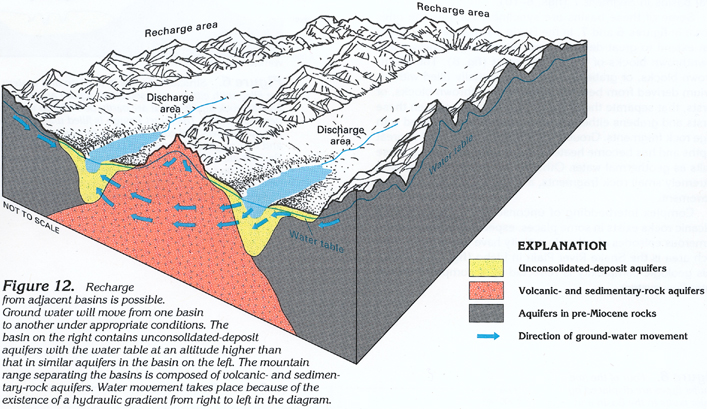
Water in all the aquifers in Segment 7 moves from recharge areas down the hydraulic gradient to discharge areas. Many of the aquifers in the three-State area are exposed at land surface and receive recharge directly from precipitation on outcrop areas. Other aquifers are buried and are recharged by downward leakage from overlying aquifers. In some places, certain aquifers receive recharge as lateral flow from adjacent aquifers. Lateral recharge is a characteristic of some aquifers that fill the many structural basins in Segment 7. For example, where the unconsolidated-deposit aquifers in basins are separated by a mountain range that consists of volcanic- and sedimentary-rock aquifers, water can move from one basin at a high altitude through these aquifers to another basin at a lower altitude (fig. 12).
Discharge from the aquifers is by evapotranspiration, leakage to adjacent aquifers, withdrawals from wells, movement of water to surface-water bodies, and discharge from springs. Springs are particularly important as discharge points in the walls of the Snake River Canyon in Idaho. Permeable and almost impermeable rocks are complexly interbedded in places in Segment 7. The almost impermeable rock layers might retard the downward movement of ground water and create perched water-table conditions.
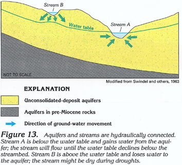
Aquifers and streams are in direct hydraulic connection in some places, particularly where the aquifers in the stream valleys consist of unconsolidated deposits (fig. 13). Water can move either from the aquifer to the stream (gaining stream labeled A in fig. 13) or from the stream to the aquifer (losing stream labeled B in fig. 13), depending on the altitude of the water level in the stream and the aquifer.
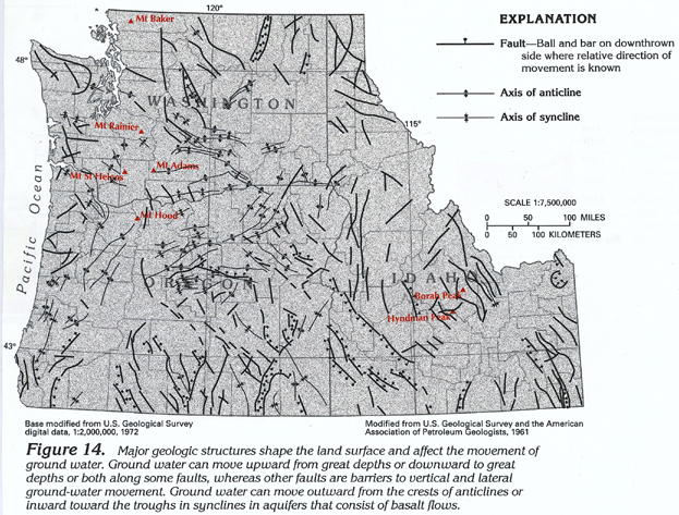
Geologic structures (faults and folds) can affect the movement of ground water. Although only major structures are shown in figure 14 because of the map scale, they demonstrate the complexity of structural features in Idaho, Oregon, and Washington.
Some fault zones are extremely permeable and might be the only conduits for water movement in some rocks. Other fault zones are filled with clay and are almost impermeable. Generally, the more consolidated and less weathered a rock is, the greater the chance that faults will increase the permeability of the rock. Open faults in consolidated rocks are conduits for recharge in mountainous areas and permit deep infiltration of water to geothermal heat sources.
Uplifting, folding, faulting, and subsidence have left their marks in Segment 7. The area contains some high mountain peaks, including Borah and Hyndman Peaks in Idaho; Mount Hood in Oregon; and Mounts Adams, Baker, Rainier, and St. Helens in Washington. Volcanic and seismic activity has taken place in the area as recently as the 1980's. The violent eruption of Mount St. Helens in May 1980 removed about 0.3 cubic mile of rock from the mountain. During 9 hours of eruption, about 540 million tons of ash were spread over an area of about 22,000 square miles.
WATER-LEVEL FLUCTUATIONS
Water levels in wells reflect the balance between ground-water recharge and discharge. Water levels rise when recharge exceeds discharge and decline when discharge exceeds recharge. Under long-term natural conditions, the two tend to be nearly in balance. As a result of ground-water development and climatic changes, the balance can change in either direction.
SHORT-TERM FLUCTUATIONS
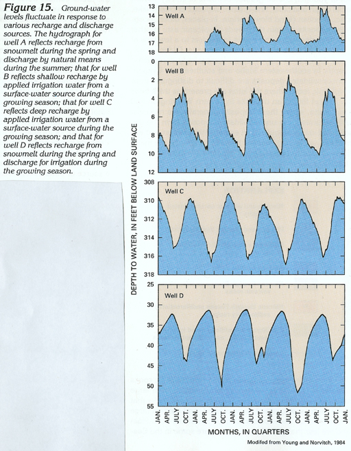
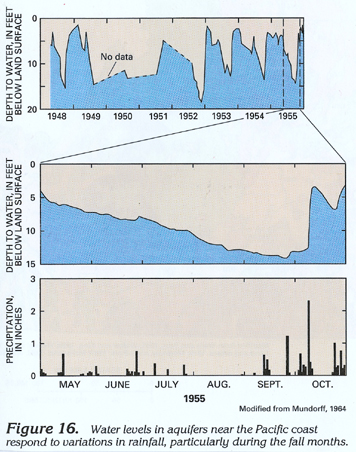
Under natural conditions in inland areas of Segment 7, ground-water levels generally are highest in the spring as a result of recharge from snowmelt (fig. 15, well A). In coastal areas, ground-water levels are highest in the late fall or winter as a result of recharge from precipitation (fig. 16). Ground-water levels decline through summer when evapotranspiration rates cause discharge to exceed recharge. Water levels continue downward until the next major seasonal recharge, thus completing the annual cycle.
In areas irrigated by surface water (fig. 15, well B), canal losses and seepage from fields constitute the principal recharge. Water levels begin to rise when water is released into canals and fields, reach a plateau throughout the summer, begin to decline at the end of the growing season, and continue to an annual low just before the start of the next irrigation season. Well B is 32 feet deep and the water level responds to recharge soon after distribution of surface water for irrigation begins. In comparison, well C (fig. 15) is 345 feet deep and the water level also responds to surface-water irrigation; however, response is delayed by about 4 to 6 weeks. Vertical percolation of water through unsaturated deposits and rocks is slow and delays recharge.
In areas irrigated by ground water, the annual cyclic fluctuations described above are reversed (fig. 15, well D). Water levels begin to decline at the start of pumping, generally in the late spring; continue to decline through the irrigation season, at the end of which time they begin an abrupt rise; continue to rise through the fall, winter, and early spring; and reach an annual peak just before the start of the next irrigation season.
The hydrographs in figure 15 are ideal examples and clearly reflect the causes for short-term water-level fluctuations. In areas where surface and ground water are used for irrigation, causes of water-level fluctuations are less easily defined. As depicted by water-level fluctuations in well A, effects of climate also affect water levels in wells B, C, and D, but are overshadowed by effects of irrigation.
LONG-TERM FLUCTUATIONS
In addition to repetition of seasonal fluctuations, a long-term hydrograph (fig. 17) indicates trends in the balance or imbalance between aquifer discharge and recharge. Long-term water-level trends generally are caused by (1) long-term precipitation cycles (for example, several years of greater-than-normal precipitation followed by several years of less-than-normal precipitation), (2) continuing ground-water withdrawals in excess of available recharge, and (3) improvements in irrigation efficiencies, such as changing from furrow and flood irrigation to sprinkler irrigation, and sealing or lining earthen canals, thus reducing water-transmission losses and thereby decreasing recharge to an aquifer.
A long-term hydrograph of water levels in an observation well in Minidoka County, Idaho, is shown in figure 17. The 194-foot-deep well was completed in the Pliocene and younger basaltic-rock aquifer, which generally is unconfined underlying the Snake River Plain. The well is in an area where ground water is withdrawn for irrigation but is near an area irrigated with surface water diverted from the Snake River. The gradual long-term declining trend in ground-water level can be attributed primarily to less-than-normal precipitation, which determined the surface-water supply available for irrigation during the period 1951-62, and to decreased surface-water diversions and improvements in surface-water-irrigation efficiencies during the period 1963-80.
Replacing irrigated farmland with urban shopping centers, residential subdivisions, and other types of land use also can affect recharge rates to an aquifer. Mining activities can cause similar effects.
Reliance on ground water for public-supply, domestic and commercial, agricultural, and industrial purposes is increasing in Idaho, Oregon, and Washington. In the more arid parts of Segment 7, increased ground-water withdrawals generally cause ground-water levels to decline.
GROUND-WATER QUALITY
Ground water in Idaho, Oregon, and Washington generally is fresh (dissolved-solids concentration of 1,000 milligrams per liter or less) and chemically suitable for most uses. Because of sparse settlement in much of the area, little ground water has been contaminated as the result of human activities, except locally. Measured concentrations of dissolved solids in ground water (fig. 18) exceed 1,000 milligrams per liter only in scattered areas throughout the three States.
Under natural conditions, dissolved minerals in ground water are primarily a result of the chemical interaction between water and the deposits or rocks through which the water moves. The water partially dissolves some of the minerals as it moves from areas of recharge to areas of discharge. The longer the water is in contact with the minerals that compose the aquifer, the more mineralized the water becomes. Therefore, the exact chemical composition of the water at any given place is determined by the combination of the mineralogy of the deposits or rocks that compose the aquifer and the residence time of the water in the aquifer.
Some ground water contains large natural concentrations of particular minerals (saltwater) and is unfit for human consumption and many other uses. Saltwater can contaminate freshwater aquifers by entering either from the ocean in coastal areas or along faults in other areas. Natural contamination of ground water takes place slowly relative to contamination from human activities.
Ground water can be contaminated by numerous organic chemicals (especially pesticide residues or byproducts, oils, phenols, and solvents); metals (especially chromium, lead, and mercury); and compounds produced by a myriad of human activities. Contamination is classified as being from either a point or a nonpoint source. Point sources are specific local sites of a few acres or less and include industrial and municipal landfills; surface impoundments, such as lagoons, pits, and ponds; underground storage tanks containing petroleum, toxic chemicals, and wastes; spills of chemicals and petroleum products during transport or transfer operations; and injection or disposal wells that receive hazardous waste or wastewater. Non-point sources extend over broad areas of hundreds or thousands of acres and include fields treated with agricultural pesticides and fertilizers, concentrations of septic-tank drain-fields and cesspools in suburban areas, saltwater or geothermal water encroachment, salt from highway deicing, animal feedlots, and mining operations.
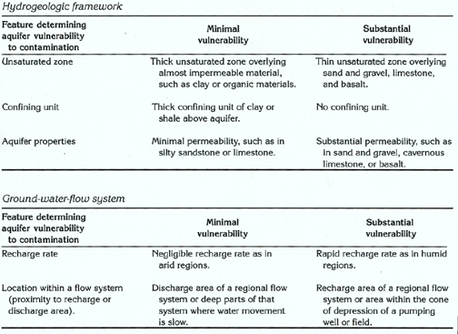
Shallow, unconfined aquifers with rapid recharge rates generally are most vulnerable to contamination from the land surface because of the rapid percolation of ground water along short flowpaths from the land surface to the water table. This rapid percolation means that the contaminated water is in contact with soil minerals for only a brief time; accordingly, there is little potential for the contaminants to be absorbed by the soil. Confined aquifers are usually deeply buried and are covered by a confining unit; as a result, they are much less vulnerable to contamination than are shallow, unconfined aquifers. The following table lists features that affect aquifer vulnerability to contamination and indicates the relative degree of vulnerability, which is based on characteristics of the features.
The concentration of dissolved solids in ground water provides a standard for categorizing the general chemical quality of the water. The dissolved-solids concentration is determined largely by the types of deposits and rocks through which the water moves and the length of time the water is in the aquifer, as well as by contaminants in the water. Secondary Federal drinking-water regulations recommend a maximum dissolved-solids concentration of 500 milligrams per liter. In some areas, however, water with a dissolved-solids concentration of as much as 1,000 milligrams per liter is used for human consumption. Dissolved-solids concentrations that exceed 500 milligrams per liter are common near coastal areas and in deep aquifers in Idaho, Oregon, and Washington (fig. 18). Most deep aquifers are overlain by shallower aquifers that contain water with smaller dissolved-solids concentrations. However, in some irrigated areas, water in shallow aquifers contains a large dissolved-solids concentration that resulted from percolation of the irrigation water, and in central parts of closed basins, evaporation concentrates minerals in shallow ground water.
Areas where dissolved-solids concentrations exceed 500 milligrams per liter (fig. 18) reflect (1) irrigation, chiefly on the Snake River Plain and the Columbia Plateau, (2) saltwater in underlying consolidated marine sedimentary rocks in Oregon and Washington, (3) evaporation in closed basins in southcentral Oregon, and (4) geothermal water leaking into the cold freshwater system, chiefly in Idaho and Oregon.
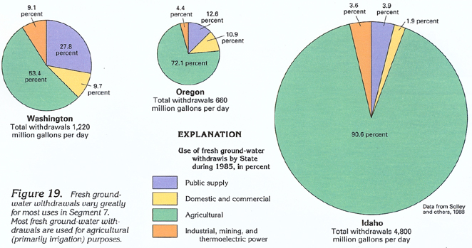
FRESH GROUND-WATER WITHDRAWALS
Fresh ground-water withdrawals during 1985 were about 4,800 million gallons per day in Idaho, about 660 million gallons per day in Oregon, and about 1,220 million gallons per day in Washington (fig. 19). Categories of use in each State also vary. Withdrawals for agricultural (primarily irrigation) purposes exceed all other uses in each State. Withdrawals for irrigation are particularly large in Idaho. Withdrawals for public supply are largest in Washington, which is the most densely populated of the three States.
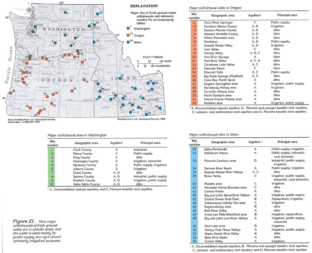
Fresh ground-water withdrawals by county vary as shown in figure 20. Rates of withdrawal are distributed evenly throughout some counties; however, most major withdrawal sites are for irrigation or public supply and, therefore, are denser in specific areas. Except for Clark, King, Kitsap, Thurston, Pierce, and Spokane Counties, Wash., which contain the cities of Vancouver, Seattle, Bremerton, Olympia, Tacoma, and Spokane, respectively, and Multonomah County, Oreg., which contains the city of Portland, all the counties shown in figure 20 that have withdrawals of 10 million gallons per day or more use most of the water for agricultural purposes. The Snake River Plain in Idaho and the Columbia Plateau in Oregon and Washington, which are two areas of intensive agricultural activity, are particularly prominent in figure 20.
Most of the water is withdrawn at specific sites (fig.
21). Large-scale irrigation projects account for most of the
withdrawals, but those for public supply also are important. The
tables accompanying figure 21 list
the major withdrawal sites by name and aquifer and indicate the
purpose for which the water is used.