GROUND WATER ATLAS of the UNITED STATES
Iowa, Michigan, Minnesota, Wisconsin
HA 730-J
Cretaceous aquifer
There are two different files for each illustration
- A 90 ppi JPEG file, suitable for screen viewing is accessed
through the thumbnail image.
- A tiff file is accessed through the "tiff file"
link. All files are Adobe Photoshop. These files have been compressed
with GNU's gzip utility. If your web browser defaults to a screen
display of the file, turn on the "Load to local disk"
option before downloading. Download and process these tiff files
as ascii, not binary.
Hydrogeology
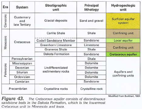
Figure 43 Correlation chart showing characteristics of the Cretaceous
aquifer (153K)
 downloadable tiff file J043.tif.gz (1.1MB
compressed)
downloadable tiff file J043.tif.gz (1.1MB
compressed)
Figure 44 Cross section showing water movement
through the Cretaceous aquifer (223K)
 downloadable tiff file J044.tif.gz (1.6MB
compressed)
downloadable tiff file J044.tif.gz (1.6MB
compressed)
Figure 45 Map showing potentiometric surface of
the Cretaceous aquifer (439K)
 downloadable tiff file J045.tif.gz
(3.5MB compressed)
downloadable tiff file J045.tif.gz
(3.5MB compressed)
Figure 46 Map showing potential water yields from
the Cretaceous aquifer in Iowa (162K)
 downloadable tiff file J046.tif.gz (1.5MB
compressed)
downloadable tiff file J046.tif.gz (1.5MB
compressed)
Table 2 Table showing hydraulic properties and
thickness of the Cretaceous aquifer in Iowa (84K)
 downloadable tiff file Jtab02.tif.gz (568K
compressed)
downloadable tiff file Jtab02.tif.gz (568K
compressed)
 downloadable tiff file J043.tif.gz (1.1MB
compressed)
downloadable tiff file J043.tif.gz (1.1MB
compressed) 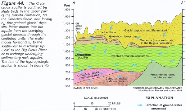 downloadable tiff file J044.tif.gz (1.6MB
compressed)
downloadable tiff file J044.tif.gz (1.6MB
compressed) 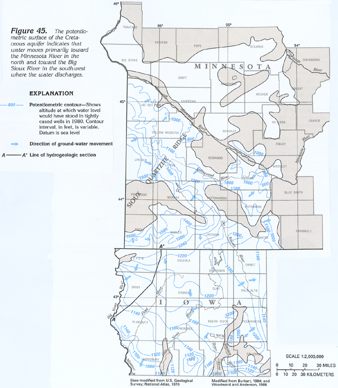 downloadable tiff file J045.tif.gz
(3.5MB compressed)
downloadable tiff file J045.tif.gz
(3.5MB compressed)  downloadable tiff file J046.tif.gz (1.5MB
compressed)
downloadable tiff file J046.tif.gz (1.5MB
compressed) 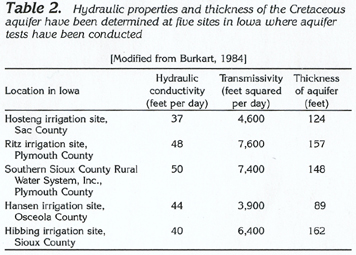 downloadable tiff file Jtab02.tif.gz (568K
compressed)
downloadable tiff file Jtab02.tif.gz (568K
compressed)