GROUND WATER ATLAS of the UNITED STATES
Illinois, Indiana, Kentucky, Ohio, Tennessee
HA 730-K
Appalachian Plateaus aquifers
There are two different files for each illustration
- A 72 ppi GIF file, suitable for screen viewing is accessed through
the thumbnail image
- An eps file, suitable for downloading to be printed or edited is accessed
through the "eps file" link. Most files are Adobe Illustrator
6.0, exceptions are noted. These files have been compressed with GNU's
gzip utility. If your web browser defaults to a screen display of the file,
turn on the "Load to local disk" option before downloading. Download
and process these eps files as ascii, not binary.
Ground-water occurrence and movement
Surficial aquifer system
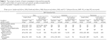
Table 5 Table showing the range of well yields in the surficial aquifer
(17K)
 editable eps file ktab5.eps.gz
(17K compressed)
editable eps file ktab5.eps.gz
(17K compressed)
Aquifers in consolidated rocks
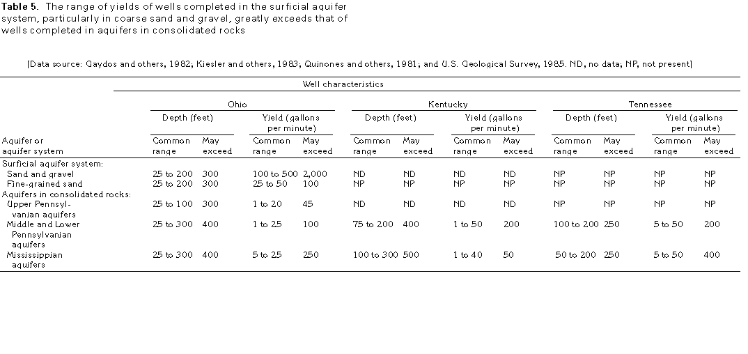
Figure 108 Diagram showing recharge of consolidated rocks (17K)
 editable eps file k108.eps.gz
(17K compressed)
editable eps file k108.eps.gz
(17K compressed)
Figure 109 Diagram showing ground-water movement (17K)
 editable eps file k109.eps.gz
(66K compressed)
editable eps file k109.eps.gz
(66K compressed)
 editable eps file ktab5.eps.gz
(17K compressed)
editable eps file ktab5.eps.gz
(17K compressed)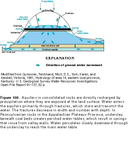 editable eps file k108.eps.gz
(17K compressed)
editable eps file k108.eps.gz
(17K compressed)  editable eps file k109.eps.gz
(66K compressed)
editable eps file k109.eps.gz
(66K compressed)