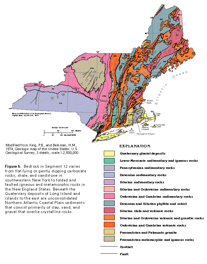
Figure 5 Map showing geology (50K)
 editable eps file M005.eps.gz
(347K compressed)
editable eps file M005.eps.gz
(347K compressed)
Figure 5 Map showing geology (50K)
editable eps file M005.eps.gz
(347K compressed)
 This illustration contains a placed image. Download the Adobe Illustrator
6 eps file M006.eps.gz (9.8M compressed)
which contains an imbedded Adobe Photoshop 3 (eps) file. You may also want
to download the editable Photoshop
file M006psh.eps.gz (9.8M compressed)
This illustration contains a placed image. Download the Adobe Illustrator
6 eps file M006.eps.gz (9.8M compressed)
which contains an imbedded Adobe Photoshop 3 (eps) file. You may also want
to download the editable Photoshop
file M006psh.eps.gz (9.8M compressed)  This illustration contains a placed image. Download the Adobe Illustrator
6 eps file M007.eps.gz (9.2M compressed)
which contains an imbedded Adobe Photoshop 3 (eps) file. You may also want
to download the editable Photoshop
file M007psh.eps.gz (9.2M compressed)
This illustration contains a placed image. Download the Adobe Illustrator
6 eps file M007.eps.gz (9.2M compressed)
which contains an imbedded Adobe Photoshop 3 (eps) file. You may also want
to download the editable Photoshop
file M007psh.eps.gz (9.2M compressed)  This illustration contains a placed image. Download the Adobe Illustrator
6 eps file M008.eps.gz (8.8M compressed)
which contains an imbedded Adobe Photoshop 3 (eps) file. You may also want
to download the editable Photoshop
file M008psh.eps.gz (8.7M compressed)
This illustration contains a placed image. Download the Adobe Illustrator
6 eps file M008.eps.gz (8.8M compressed)
which contains an imbedded Adobe Photoshop 3 (eps) file. You may also want
to download the editable Photoshop
file M008psh.eps.gz (8.7M compressed)