GROUND WATER ATLAS of the UNITED STATES
Connecticut, Maine, Massachusetts, New Hampshire, New York, Rhode Island,
Vermont
HA 730-M
Regional summary
There are two different files for each illustration
- A 72 ppi GIF file, suitable for screen viewing is accessed through
the thumbnail image
- An eps file, suitable for downloading to be printed or edited is accessed
through the "eps file" link. Most files are Adobe Illustrator
6.0, exceptions are noted. These files have been compressed with GNU's
gzip utility. If your web browser defaults to a screen display of the file,
turn on the "Load to local disk" option before downloading. Download
and process these eps files as ascii, not binary.
Major aquifers
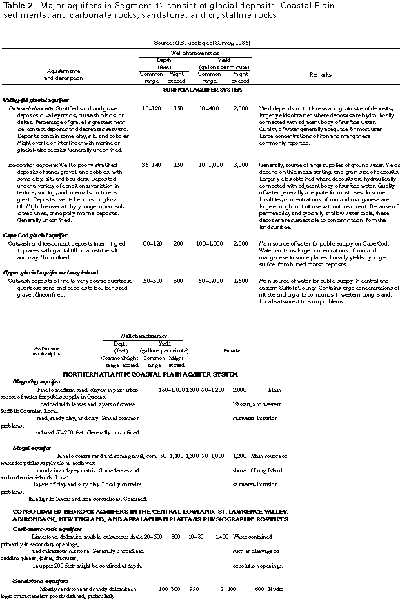
Table 2 Table showing well characteristics by aquifer (17K)
 editable eps file Mtab2.eps.gz
(17K compressed)
editable eps file Mtab2.eps.gz
(17K compressed)
Figure 9 Map of Surficial aquifer system (83K)
 editable eps
file M009.eps.gz (875K compressed)
editable eps
file M009.eps.gz (875K compressed)
Figure 10 Principal aquifer map (99K)
 editable eps
file M010.eps.gz (413K compressed)
editable eps
file M010.eps.gz (413K compressed)
Figure 11 Diagramatic section showing the Northern
Atlantic Coastal Plain aquifer system (33K)
 This illustration contains a placed image. Download the Adobe Illustrator
6 eps file M011.eps.gz (149K compressed)
which contains an imbedded Adobe Photoshop 3 (eps) file. You may also want
to download the editable Photoshop
file M011psh.eps.gz (116K compressed)
This illustration contains a placed image. Download the Adobe Illustrator
6 eps file M011.eps.gz (149K compressed)
which contains an imbedded Adobe Photoshop 3 (eps) file. You may also want
to download the editable Photoshop
file M011psh.eps.gz (116K compressed)
 editable eps file Mtab2.eps.gz
(17K compressed)
editable eps file Mtab2.eps.gz
(17K compressed) 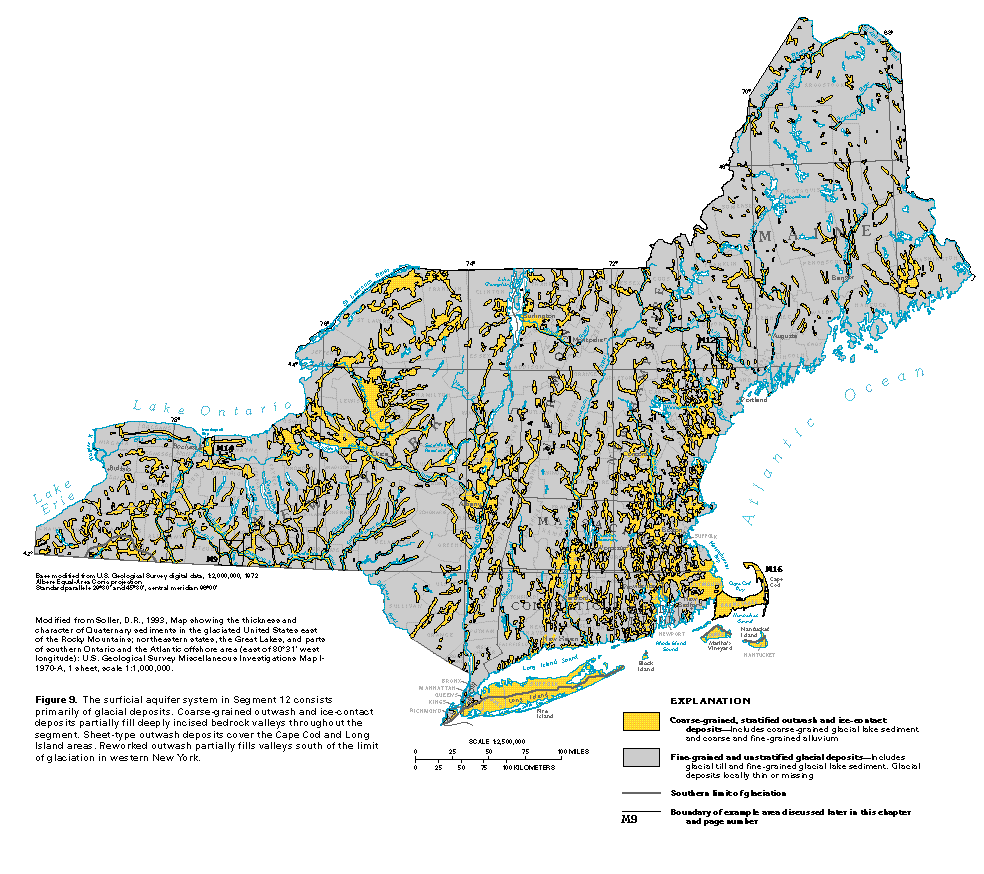 editable eps
file M009.eps.gz (875K compressed)
editable eps
file M009.eps.gz (875K compressed) 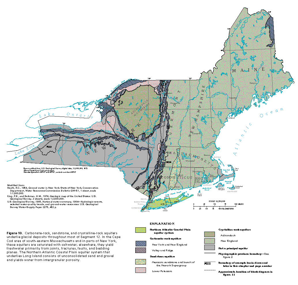 editable eps
file M010.eps.gz (413K compressed)
editable eps
file M010.eps.gz (413K compressed) 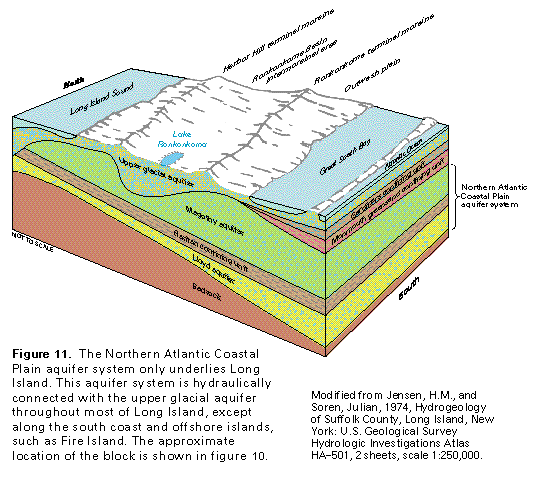 This illustration contains a placed image. Download the Adobe Illustrator
6 eps file M011.eps.gz (149K compressed)
which contains an imbedded Adobe Photoshop 3 (eps) file. You may also want
to download the editable Photoshop
file M011psh.eps.gz (116K compressed)
This illustration contains a placed image. Download the Adobe Illustrator
6 eps file M011.eps.gz (149K compressed)
which contains an imbedded Adobe Photoshop 3 (eps) file. You may also want
to download the editable Photoshop
file M011psh.eps.gz (116K compressed)