INTRODUCTION
The Hawaiian islands are the exposed parts of the Hawaiian Ridge, which is a large volcanic mountain range on the sea floor. Most of the Hawaiian Ridge is below sea level (fig. 31). The State of Hawaii consists of a group of 132 islands, reefs, and shoals that extend for more than 1,500 miles from southeast to northwest across the central Pacific Ocean between about 155 and 179 degrees west longitude and about 19 to 28 degrees north latitude. The main inhabited islands are at the southeastern end of the group (fig. 31); not all the small islands, reefs, and shoals included in the State are shown.
The Hawaiian islands are geologically youngest in the southeast
and oldest in the northwest. This report discusses only the eight
largest islands near the southeastern end of the group; these
eight main islands account for practically all of the 6,426-square-mile
land area of the State. The eight islands and their approximate
size, in square miles, from southeast to northwest are Hawaii,
4,021; Maui, 728; Kahoolawe, 45; Lanai, 141; Molokai, 259; Oahu,
603; Kauai, 553; and Niihau, 71. The total resident population
in 1995 was 1,179,198, of which about 75 percent were on the island
of Oahu. Honolulu, which is on Oahu, is the largest and most developed
city and had a population of 369,485 in 1995. In addition to the
resident population, a visitor population of about 150,000 has
typically been present at any given time during the 1990's. Many
of these visitors stay in Honolulu.
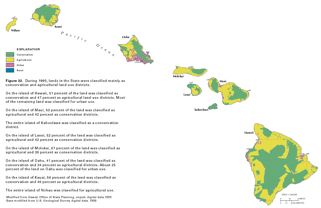
The State Land Use Commission is responsible for classifying the
lands of the State into one of four categories called districts:
conservation, agricultural, urban, or rural (fig.
32). In 1995, conservation, agricultural, urban, and rural
districts accounted for about 48, 47, 5, and 0.2 percent of the
land area in the State, respectively. Conservation districts include
areas necessary for protecting the State's watersheds and water
resources and are typically located in high-altitude, high-rainfall
areas. Much of the urban development in Hawaii is in the lowland
coastal areas of each island. Agricultural irrigation can place
large demands on the water resources; prior to the 1990's, one
of the largest uses of water was for sugarcane irrigation. The
five largest islands (Hawaii, Maui, Molokai, Oahu, and Kauai)
have extensive areas of mountainous land where urbanization and
large-scale agricultural operations are not feasible.
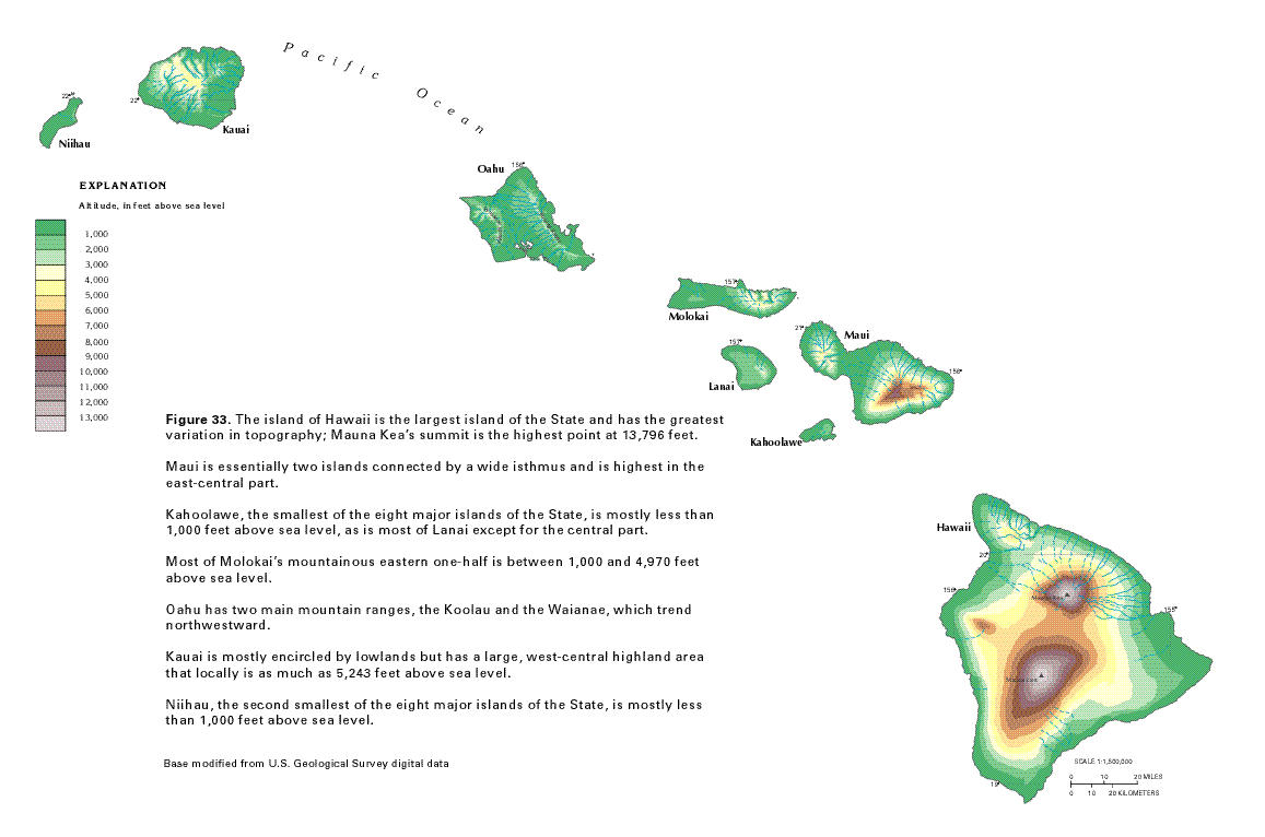
The island of Hawaii is the largest island of the State (fig. 33) and has the highest altitude at 13,796 feet. Maui is about 10,000 feet above sea level in its eastern part and about 5,800 feet above sea level in its western part; a broad lowland area separates the two parts. Kahoolawe is the smallest of the eight major islands and is only about 1,500 feet above sea level in its eastern, highest part. Lanai is about 3,400 feet above sea level in its highest part, but much of the island is less than 1,000 feet above sea level. Molokai is mountainous in its eastern half, where it rises to about 5,000 feet above sea level, but most of the island is less than 1,000 feet above sea level. Oahu has a mountainous ridge along its eastern side and another mountainous area along the western side, where it rises to about 4,000 feet above sea level; however, most of Oahu is less than 1,000 feet above sea level. Kauai is about 5,200 feet above sea level in its central part, but from the base of the mountains shoreward, large areas of the island are less than 1,000 feet above sea level in the southern, eastern, and northern parts. Niihau is mostly less than 1,000 feet above sea level, except for a narrow ridge about 1,300 feet above sea level along its northeastern side. The topography of each island has a profound effect on development and climate.
Climatic Effects
The Hawaiian islands are near the northern margin of the tropics,
and because of the prevailing northeast tradewinds and the buffering
effect of the surrounding ocean, air temperature at a given location
in Hawaii is generally equable. At the Honolulu International
Airport, for example, the warmest month of the year is August,
which has a mean temperature of 80.5 degrees Fahrenheit, and the
coolest month is February, which has a mean temperature of 72.0
degrees Fahrenheit. Air temperature can vary greatly from one
location to another in Hawaii. The air temperature in the eight-island
group can range from about 95 degrees Fahrenheit at sea level
to below freezing at the top of some peaks on the island of Hawaii.
In the geologic past, these peaks have been glaciated.
Northeasterly tradewinds are present about 85 to 95 percent
of the time during the summer months (May through September),
and 50 to 80 percent of the time during the winter months (October
through April). The tradewinds are occasionally interrupted by
large-scale storm systems which pass near the islands. The southwestern
parts of some islands receive most of their rainfall from these
severe storms, which produce a relatively uniform spatial distribution
of precipitation. In general, the northeastern, or windward sides
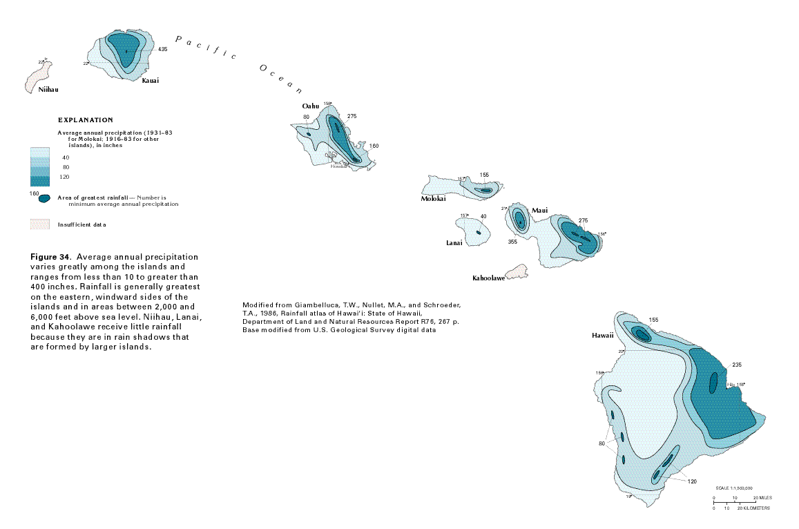
of the islands are wettest (fig. 34).
This pattern is controlled by the orographic lifting of moisture-laden
northeasterly tradewinds along the windward slopes of the islands.
The winds blow across open ocean before arriving at the islands;
when the moisture-laden air mass rises over the mountains, the
moisture condenses as precipitation. Maximum rainfall occurs between
altitudes of 2,000 and 6,000 feet above sea level, but exact amounts
vary depending on the form, location, and topography of each island.
Above 6,000 feet, precipitation decreases and the highest altitudes
are semiarid. High mountain areas are dry because the upslope
flow of moist air is prevented from penetrating above altitudes
of about 6,000 to 8,000 feet by a temperature inversion. Areas
that are leeward (southwest) of mountain barriers are generally
dry because air is desiccated during its ascent over an upwind
orographic barrier. This is known as the rain-shadow effect.
On Kauai, the island summit receives more than 435 inches of average annual rainfall (1916-83). West Maui has a small area where average annual rainfall is greater than 355 inches. Average annual rainfall is greater than 275 inches on the northeastern parts of Maui and Oahu, and greater than 235 inches on the northeastern part of the island of Hawaii. Because the island of Lanai is in the rain shadow of Maui and Molokai, it receives much less rain than the larger islands. Most of the southwestern coastal areas of all islands receive less than 40 inches of rain annually; the island of Hawaii has areas at high altitudes that receive less than 20 inches.
Two rainfall seasons are typical-a wet season during the winter months from October through April and a dry season during the summer months from May through September. An exception is the western side of the island of Hawaii, where summer months are wettest because of a thermally driven sea breeze.
Evapotranspiration, which is the loss of water to the atmosphere by the combination of transpiration of plants and direct evaporation from land and water surfaces, is a major component of the hydrologic budget of the islands. In the Honolulu area of Oahu, for example, actual evapotranspiration was estimated to be about 40 percent of the total water (rainfall plus irrigation) falling on or applied to the ground surface during 1946-75. Pan evaporation is the main measurement used in Hawaii to assess the amount of water loss by evapotranspiration. Over the open ocean, the estimated annual pan-evaporation rate is 65 inches. As with precipitation, pan-evaporation rates in Hawaii are related to topography. At altitudes between 2,000 and 4,000 feet, where humidity is high and sunlight intensity is reduced because of clouds, pan-evaporation rates are reduced to as low as 25 percent of the open-ocean rate. In the leeward coastal areas, wind carrying dry, warm air increases annual pan-evaporation rates to as much as 100 inches. At the summits of Mauna Kea and Mauna Loa on the island of Hawaii, annual pan-evaporation rates exceed 70 inches because of clear skies and dry air.
The amount of recharge available to enter the aquifers on an annual basis is about equal to average annual precipitation minus water losses (average annual runoff and evapotranspiration). Runoff is directly related to rainfall, topography, soil type, and land use, and ranges from less than 5 to as much as 200 inches per year. Runoff typically averages about 10 to 40 percent of the average annual precipitation, but is greater than average where precipitation is high and slopes are steep and where precipitation falls on less-permeable land surfaces. Runoff is less than average where low amounts of precipitation fall on gentle slopes or where precipitation falls on highly permeable soils or rocks. Streams generally are small and have steep gradients, and many flow only immediately after periods of rainfall. Some streams, however, receive water from aquifers and have perennial flow.
Areal Distribution of Aquifers
The rocks of the Hawaiian islands can be grouped into two general
hydrogeologic categories. The principal aquifers occur in volcanic
rocks ranging in age from Miocene to Holocene. Less-important
aquifers occur in Quaternary-age sedimentary deposits of alluvium,
coralline limestone, and cemented beach or dune sand. Volcanic-rock
aquifers are found throughout the eight major islands (fig.
35) and are locally overlain by sedimentary deposits. The
areas where sedimentary deposits are at the land surface on the
eight major islands are shown in figure
35.
Volcanic-rock aquifers are by far the most extensive and productive aquifers in the Hawaiian islands. These aquifers are formed by layered sequences of permeable basalt. Less-productive volcanic-rock aquifers are formed by sequences of less-permeable, thick-bedded basalt. The basalt found in some areas, such as much of Kahoolawe, Niihau, and the western third of Molokai, may be permeable, but yields little potable water mainly because these areas receive little recharge.
Consolidated sedimentary deposits are found mostly in the coastal areas. The limestone is highly permeable in many places and usually yields brackish water or saltwater because of good hydraulic connection with the ocean and because of low recharge to the limestone. The brackish water is used for cooling and industrial purposes, particularly in southern Oahu. In addition, treated wastewater is injected into the limestone where it contains brackish water or saltwater. Coralline limestone overlies much of the isthmus area of Maui, but these rocks are not a significant source of potable water.
The unconsolidated sedimentary deposits consist of alluvium, beach and dune sand, and lagoonal mud and clayey sand. In some places, these deposits are interbedded with consolidated rocks. Sedimentary deposits, as well as weathered volcanic rocks are important to the ground-water hydrology of the islands in some areas. The combination of weathered volcanic rocks and overlying sedimentary material forms a low-permeability material called caprock in areas overlying high-permeability volcanic rocks. The caprock confines water in the volcanic rocks so that, in places such as the coastal plain of Oahu, freshwater exists in the volcanic rocks beneath brackish water or saltwater in the caprock.
The climate of the Hawaiian islands has a profound effect on
weathering processes that affect the hydraulic properties of sedimentary
deposits and volcanic rocks (especially ash and tuff). The permeability
of the sediments and volcanic rocks can be greatly reduced by
chemical weathering. During the weathering process, original pore
spaces are closed by swelling of mineral particles as chemical
changes cause the deposits and rocks to disintegrate. Weathering
processes consist chiefly of oxidation, hydration, and carbonation
(reaction with carbon dioxide) of various minerals in the rocks.
Geology
A long chain of volcanoes known as the Hawaiian Ridge extends
northwestward across the central Pacific Ocean. The volcanoes
are youngest in the southeast and become progressively older to
the northwest. The volcanoes of the Hawaiian Ridge have formed
as a plate of the Earth's crust beneath the Pacific Ocean moves
northward and westward relative to an area of anomalously high
temperature, called a hot spot, in the Earth's mantle. As a volcano
moves northwestward away from the hot spot, eruptions become less
frequent, and a new volcano begins to form above the hot spot.
Many of the younger volcanoes have grown above sea level, forming
islands. As islands age, they erode and subside, eventually becoming
atolls and then seamounts.
Some of the eight major Hawaiian islands, such as Kahoolawe, are composed of a single volcano, whereas Hawaii is formed by five volcanoes. Some of the older volcanoes have not erupted for millions of years, but as many as eight of the younger volcanoes may have erupted in the last 10,000 years. Historic eruptions have been recorded on five volcanoes: East Maui Volcano-on the island of Maui; Hualalai, Mauna Loa, and Kilauea-on the island of Hawaii; and Loihi-a submarine volcano currently (1998) forming to the southeast of Hawaii. Kilauea also is currently erupting. The volcanoes are called shield volcanoes because they are shaped like broad, flattened domes.
The evolution of Hawaiian volcanoes generally progresses through four distinct stages-preshield, shield, postshield, and rejuvenated. However, not all Hawaiian volcanoes have a postshield stage or a rejuvenated stage. The preshield stage is the earliest, submarine phase of activity, and is known primarily from studies of Loihi. Lava from the preshield stage consists predominantly of alkalic basalt (basalt that is low in silica and high in sodium and potassium). Lava from the principal stage of volcano building, called the shield stage, consists of fluid tholeiitic basalts (silica-saturated basalt) that characteristically form thin flows. This basalt forms during submarine, as well as subaerial, eruptions. A large central caldera, or craterlike depression, can form during the preshield or shield stages and might later be partly or completely filled during subsequent eruptions. Thousands of flows erupt from the central caldera and from two or three rift zones that radiate out from the caldera. Intrusive dikes fed by rising magma extend down the rift zones and may erupt if they reach the surface. The shield stage is the most voluminous phase of eruptive activity during which 95 to 98 percent of the volcano is formed. The postshield stage is marked by a change in lava chemistry and character. Postshield-stage lava includes alkalic basalt, and more viscous hawaiite, ankaramite, mugearite, and trachyte. Lava from the postshield stage may erupt from locations outside of the rift zones formed during the shield stage. Postshield-stage lava forms a veneer atop the shield-stage basalt. Eruptions of more viscous lava generally are explosive and may produce pyroclastic material (ash, cinder, spatter, and larger blocks), as well as thick, massive lava flows. After a period of quiescence, lava such as alkalic basalt, nephelinite, and basanite, might issue from isolated vents on the volcano during the rejuvenated stage. Pyroclastic material can be deposited during all of the subaerial stages of eruption.
Clastic sedimentary deposits, which primarily are alluvium derived
from erosion of the volcanic rocks, have accumulated on the flanks
of the islands. In some places, the clastic sediments are interbedded
with coralline limestone that formed as reef deposits in shallow
marine waters.
The island of Hawaii consists of five volcanoes, discussed here from oldest to youngest (fig. 36). All of the volcanic rocks range in age from Pleistocene to Holocene. Kohala Volcano, which forms the island's northwestern tip, consists mostly of the shield-stage, mainly tholeiitic Pololu Volcanics and is capped by flows of the postshield-stage Hawi Volcanics. Hualalai Volcano, which forms part of the island's west coast, is covered by the postshield-stage Hualalai Volcanics. Mauna Kea Volcano, which is southeast of Kohala Volcano, primarily consists of the shield- and postshield-stage Hamakua Volcanics, which is overlain by the postshield-stage Laupahoehoe Volcanics. In the central part of the island, the bottom unit of Mauna Loa Volcano is the Ninole Basalt; which is overlain by the Kahuku Basalt; which is in turn overlain by the Kau Basalt, the most widespread geologic unit on the island. All three units of Mauna Loa Volcano consist of shield-stage tholeiitic basalt. Kilauea Volcano, which forms the southeastern part of the island, contains shield-stage tholeiitic basalts, the Hilina Basalt and the younger Puna Basalt. Rift zones, marked by cones and fissures, contain numerous volcanic dikes, and are found on all the volcanoes. Small beaches composed of thin, unconsolidated sand, some created as lava enters the ocean (Hawaii's famous black sand beaches), fringe parts of the island's coastline.
Maui consists of two volcanoes-the older West Maui Volcano and the larger East Maui Volcano (Haleakala). The two volcanoes are separated by an isthmus that is covered with deposits of alluvium and coralline limestone that are as much as 5 miles wide. The Pleistocene-age rocks of West Maui Volcano consist of the mostly shield-stage Wailuku Basalt, which is overlain by the postshield-stage Honolua Volcanics and rejuvenated-stage Lahaina Volcanics. The Pleistocene- to Holocene-age rocks of East Maui Volcano consist of the tholeiitic, shield-stage Honomanu Basalt, which is overlain by the postshield-stage Kula Volcanics and the younger rejuvenated-stage Hana Volcanics. The Kula Volcanics and the Hana Volcanics are the most widespread geologic units exposed at the land surface on Maui. The East Maui Volcano has three rift zones and the West Maui Volcano has two.
Kahoolawe is a single, relatively small volcano. The Pleistocene-age Kanapou Volcanics forms most of the island and includes both shield-and postshield-stage lava. Rejuvenated-stage vents and small areas of alluvium are present at scattered places near the shoreline.
The island of Lanai is a single volcano, and all of the island's shield-stage tholeiitic rocks are mapped as the Pleistocene-age Lanai Basalt. Sedimentary deposits, predominantly alluvium but with small areas of consolidated conglomerate, fill many of the basins in the island's interior. Dikes are present in three rift zones radiating from the volcano's summit.
Molokai consists of two volcanoes, the older West Molokai Volcano and the larger East Molokai Volcano, joined by a plain. Both the West and East Molokai Volcanics consist of shield- and postshield-stage volcanic rocks ranging in age from Pliocene to Pleistocene. The widespread East Molokai Volcanics is separated into two informal members-the thick lower member that is mostly tholeiitic basalt and the thinner upper member that contains more alkalic basalt. The rejuvenated-stage Pleistocene-age Kalaupapa Volcanics forms a peninsula on Molokai's northern coast. Volcanic dikes are found in the rift zones of both volcanoes.
Oahu consists of two volcanoes-the older Waianae Volcano in the west and the larger Koolau Volcano in the east. The Pliocene-age Waianae Volcanics is divided into four members. The lower two members, the Lualualei (shield-stage) and the Kamaileunu (shield- and postshield-stage) Members, are combined on the map in this report, and the upper Palehua and Kolekole Members, which consist largely of alkalic basalt, are shown separately. The shield-stage tholeiitic rocks of the younger Koolau Volcano are named the Koolau Basalt. The Pliocene-age Koolau Basalt is the most widespread geologic unit exposed on Oahu. Rejuvenated-stage eruptions from about 50 vents scattered on the southeastern part of Koolau Volcano form the Honolulu Volcanics, which ranges in age from Pleistocene to Holocene. The largest rift zones in the Koolau and Waianae Volcanoes are on a nearly parallel northwest-southeast trend: other rift zones trend north and northeast. Oahu has larger areas of sedimentary deposits than any other island, and these deposits contain coralline limestone in coastal areas.
The geology of Kauai is complex and the island may consist of more than one volcano. Two geologic formations-the mainly shield-stage Waimea Canyon Basalt and the rejuvenated-stage Koloa Volcanics, have been identified. The Waimea Canyon Basalt, which ranges in age from Miocene to Pliocene, is divided into the Napali, the Haupu, the Olokele, and the Makaweli Members primarily on the basis of the bedding characteristics and structural relations of the rocks. The Pliocene- to Pleistocene-age Koloa Volcanics overlies the Waimea Canyon Basalt and is exposed at the land surface over most of the eastern half of Kauai. Dikes are exposed throughout much of the island. Clastic sedimentary deposits, which include lithified sand dunes, are scattered primarily around the periphery of the island.
Niihau consists of the deeply eroded remnants of a single volcano. The core of the island is the mainly shield-stage Miocene- to Pliocene-age Paniau Basalt, which is intruded by dikes and overlain by the rejuvenated-stage Pliocene- to Pleistocene-age Kiekie Basalt. Alluvial deposits are extensive on Niihau, and some of the alluvium is consolidated.
Ground-Water Occurrence and Movement
Certain geologic and hydrologic characteristics of the Hawaiian
islands favor the occurrence and retention of freshwater. The
larger islands have extremely productive freshwater aquifers.
However, the geologic and hydrologic characteristics of the aquifers
vary widely. The modes of emplacement of the volcanic rocks and
sedimentary deposits and the subsequent weathering processes to
which they have been subjected have resulted in a wide range of
the hydraulic properties that control the storage and flow of
water. Sedimentary deposits and some types of volcanic rocks (chiefly
pyroclastic material) that typically are considered to be productive
aquifers in much of the conterminous United States are commonly
confining units or relatively poor aquifers in the Hawaiian islands.
Basalt with thick lava-flow units, weathered ash and tuff beds,
and unconsolidated coastal-plain and valley-fill sedimentary deposits
generally are of low permeability, and impede the seaward and
lateral movement of freshwater (defined in this report as water
that contains less than 1,000 milligrams per liter dissolved solids).
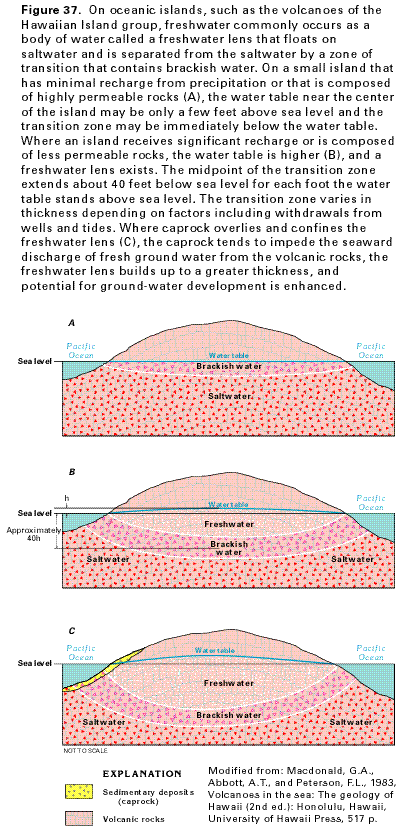
The largest bodies of fresh ground water float on saltwater within the aquifers. This occurrence is known as a freshwater lens because of the lenticular shape of such bodies of water. The Ghyben-Herzberg principle is named after two scientists who independently described a freshwater-saltwater relation for conditions in which the two fluids do not mix and the freshwater is in static equilibrium with the ocean. In a static freshwater or Ghyben-Herzberg lens, the thickness of the freshwater lens below sea level is directly proportional to the height of the top of freshwater above sea level. In principle, at a place where the water table stands 1 foot above sea level, for example, 40 feet of freshwater will be below sea level, and the freshwater lens will thus be 41 feet thick. This relation exists because seawater is about one-fortieth more dense than freshwater. In most field situations, the lower limit of the freshwater is not a sharp boundary because mixing creates a zone of transition that separates freshwater from the saltwater body. The transition zone contains brackish water (water that contains between 1,000 and 35,000 milligrams per liter dissolved solids) and can be quite thick (several tens to hundreds of feet) depending on the extent of mixing. In many cases, the depth predicted by the Ghyben-Herzberg principle is about the depth where the brackish water in the transition zone has a dissolved-solids concentration about 50 percent of seawater.
On a small island that receives little precipitation or is made up of rocks that are highly permeable, the water level is just above sea level and the thickness of freshwater below sea level may be very thin. In some places where freshwater is significantly mixed with saltwater, brackish water may exist immediately below the water table (fig. 37A). Where an aquifer receives more rainfall or is less permeable, the freshwater lens is thicker (fig. 37B). The regional movement of fresh ground water is from interior areas toward the ocean, and all of the water discharges diffusely to the ocean or at springs near sea level.
In some coastal areas, such as southern Oahu, highly permeable volcanic-rock aquifers are overlain by a confining unit, called caprock, that consists of unconsolidated and consolidated sediments and weathered volcanic rock (fig. 37C). The low overall permeability of the caprock impedes ground-water discharge to the ocean and results in a freshwater wedge inland that is thicker than it would be in the absence of the caprock. In places with a caprock, inland ground-water levels are at higher altitudes and the freshwater lens is significantly thicker than in places without a caprock.
For a given recharge rate, freshwater hydraulic heads will be lower in high-permeability rocks than in low-permeability rocks. In the most permeable volcanic rocks, the water table is generally no more than several tens of feet above sea level, indicative of a freshwater lens. In low-permeability volcanic rocks, ground-water flow is impeded to a greater extent, and higher water levels result. Water levels in these rocks are commonly greater than several tens of feet above sea level, and the rocks are fully saturated below the water table.
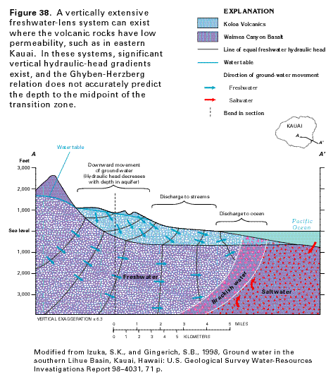
In some low-permeability volcanic-rock aquifers, such as in eastern Kauai (fig. 38), a vertically extensive freshwater-lens system develops with freshwater standing several hundreds or even thousands of feet above sea level. In such vertically extensive freshwater-lens systems, substantial vertical, freshwater hydraulic-head gradients exist in the aquifer and the Ghyben-Herzberg principle is not valid for predicting the depth at which saltwater lies beneath freshwater. Much of the fresh ground water in a vertically extensive freshwater-lens system discharges directly to stream valleys above sea level where the ground surface intersects the water table.
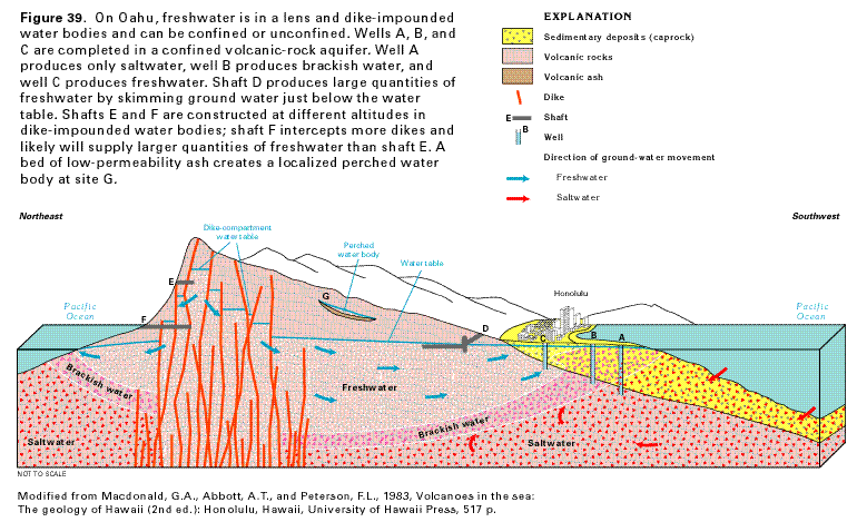
Dike-impounded water is an important source of low-salinity water on some of the islands. Sub-vertical dike systems tend to compartmentalize areas of permeable volcanic rocks, chiefly in the rift zones or caldera of a volcano. The dikes and rocks they intrude are known in Hawaii as dike complexes. Dikes impound water to great heights, as much as 3,300 feet above sea level on the islands of Maui and Hawaii and as much as 1,600 feet above sea level on Oahu. The depth to which freshwater extends below sea level within a dike complex is not known. Where dikes have been eroded or fractured, springs might issue from openings in the dikes. Shafts in dike complexes are particularly important sources of freshwater on the eastern side of Oahu, where much of the island's precipitation falls along the dike complex in the Koolau Range.
Perched water can occur in areas where low-permeability rocks impede the downward movement of ground water sufficiently to allow a saturated water body to develop over unsaturated rocks. These low-permeability rocks include massive, thick-bedded lava flows and extensive soil and weathered ash layers. Some perched water bodies supply usable quantities of water to wells.
The occurrence of ground water in the volcanic-rock aquifers of Oahu is summarized in figure 39. A freshwater lens underlies much of Oahu. Well A, which is nearest the coast, produces saltwater from below the transition zone, and well B produces brackish water from the transition zone. Well C is the inland-most well and produces freshwater. Horizontal shaft D (sometimes called a Maui shaft) has been dug into the volcanic rocks along and just below the water table and produces large volumes of freshwater by skimming water from near the top of the freshwater lens (fig. 39). Shafts E and F (sometimes called Lanai shafts) are dug horizontally into one or more of the dike-bounded compartments. Location G (fig. 39) indicates a perched water body containing minor amounts of water.
Fresh ground water generally moves from topographically high areas towards the ocean (fig. 39). Fresh ground-water flow is predominantly downward in the inland areas, upward in the coastal areas, and horizontal in between. Ground water from the dike compartments recharges downgradient freshwater lenses. A saltwater circulation system exists beneath the freshwater lens (fig. 39). Saltwater flows landward in the deeper parts of the aquifer, rises, then mixes with fresher water and discharges to the ocean.
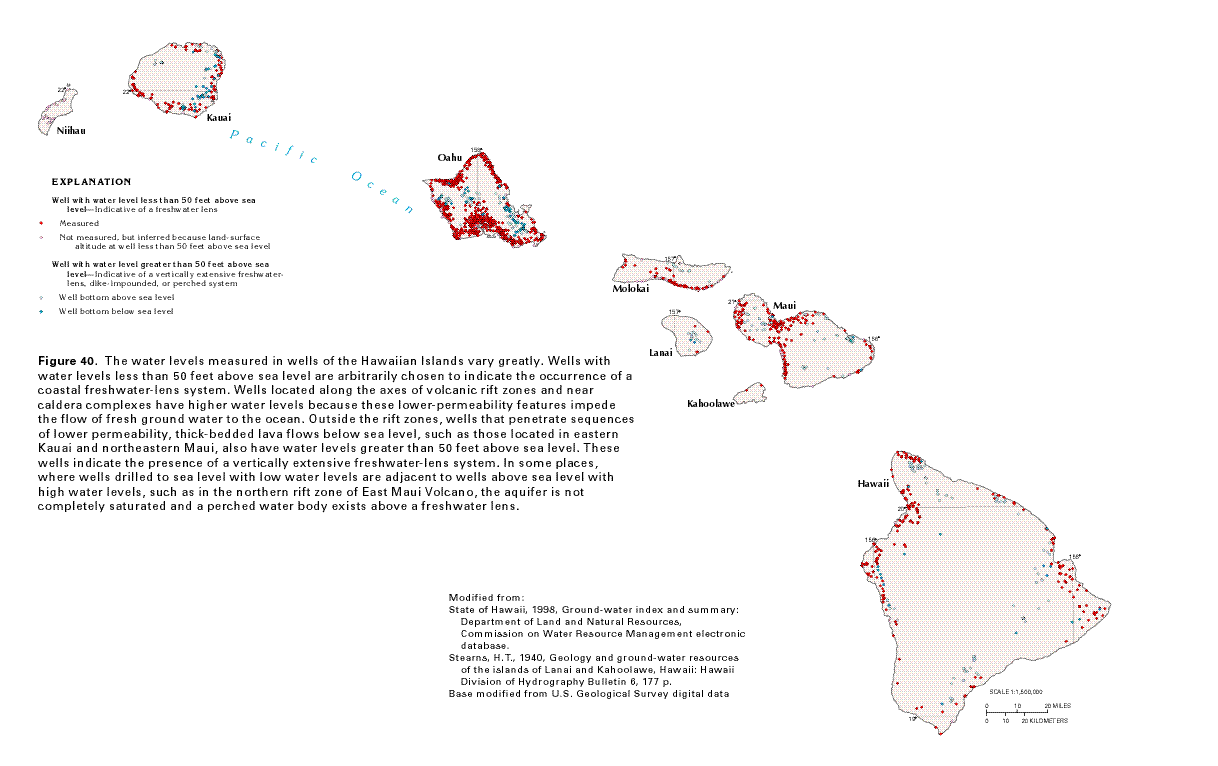
The occurrence of fresh ground water in each of the Hawaiian islands can be depicted using water levels measured in wells, shafts, and springs as shown in figure 40. Water levels less than 50 feet above sea level were arbitrarily chosen to show occurrences of freshwater lenses for figure 40. Water levels greater than 50 feet above sea level were chosen to show areas where vertically extensive freshwater-lens systems or dike-impounded water exist. Non-dike-intruded areas containing wells that penetrate below sea level and that have high water levels are considered to have vertically extensive freshwater-lens systems. Where high water levels are found in wells that do not penetrate below sea level, the possibility of a perched-water system cannot be ruled out. Although many of the ground-water systems of the islands are well understood, exploration in others is only just beginning, and these areas are not fully understood.
The island of Hawaii contains high water levels (greater than 50 feet above sea level) in the rift zones of Kilauea and Kohala Volcanoes. High water levels, possibly associated with a buried rift zone of Hualalai Volcano or fault scarps draped with lava flows, also are present along the western coast. Areas of high water levels also are found along the northern flank and eastern flanks of Mauna Kea near Hilo and on the southeastern flank of Mauna Loa.
The central isthmus and most of the coastal areas of Maui (fig. 40) have low water levels (less than 50 feet above sea level) indicative of a freshwater lens. High water levels are found in the interior of West Maui Volcano where rocks are intruded by dikes. On East Maui Volcano, high water levels are found along the northern flanks of the volcano in the high rainfall areas. Both high and low water levels occur along the northern rift zone of the volcano, indicating that a perched-water system exists above a freshwater lens. Further to the east outside of any known rift zone, high water levels occur in wells drilled below sea level indicating that a vertically extensive freshwater-lens system is present.
Few wells exist on Kahoolawe but because rainfall is low, the freshwater lens is probably thin. Lanai has high water levels in the interior of the island within the rift zone and caldera complex. In the northern part of Molokai, areas of high water levels are found in association with the northwest rift zone of East Molokai Volcano.
A large number of wells on Oahu (fig. 40) in nearshore areas around most of the periphery of the island have low water levels. High water levels are found in rift zones near the eastern and western sides of the island and low-permeability features create high water levels in the central part. Some small areas of perched water in the southern part of Oahu are in alluvial deposits, but the perched water is not a significant source of supply.
Kauai has a large area with high water levels along the eastern side of the island (fig. 40). High water levels in wells that penetrate below sea level outside of any known rift zone indicate that a vertically extensive freshwater-lens system is present. Niihau receives little rain and data from existing wells indicate that a thin freshwater lens is present throughout much of the island.
Water-Level Fluctuations
Water levels in wells fluctuate in response to both short- and
long-term natural factors and human-induced stresses. Short-term
(diurnal time scale or shorter) water-level fluctuations are caused
by ocean tides, barometric pressure changes, evapotranspiration
by phreatophytes, or earthquakes, and also by human-induced stress.
Long-term fluctuations can be caused by pumping and changes in
recharge.
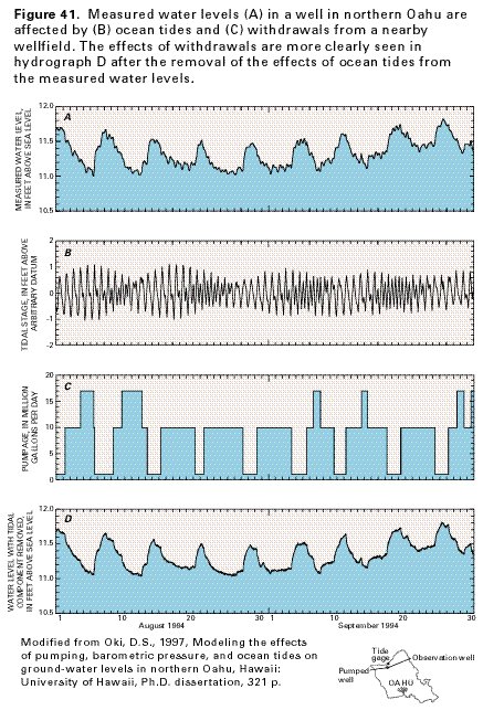
Changes in ground-water storage caused by withdrawals of water from distant or nearby wells are reflected by water-level changes in wells. Data from an observation well in northern Oahu (fig. 41) show declines and recoveries of the water table caused by intermittent pumping from nearby wells. The magnitude of the water-level decline caused by pumping is dependent on the distance between the pumped well and the observation well, the rate at which water is withdrawn, and the hydraulic characteristics of the rocks. In addition, ocean tides can cause water-level variations that are superimposed on the water-level declines caused by pumping (fig. 41); ocean tides account for about 0.1 foot of water-level fluctuation at this well. The magnitude of the water-level fluctuation caused by ocean tides is dependent on the distance of the observation well from the coast and the hydraulic characteristics of the rocks. In addition to diurnal and semidiurnal ocean tides, longer term variations in ocean level also affect ground-water levels.
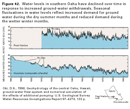
Ground-water levels generally are highest in the winter months because of greater rainfall and reduced demand for ground water, and decline during the summer months when demand for ground water is greatest. In the Pearl Harbor area, where ground-water demand for agriculture historically has been high, seasonal fluctuations in water level range from a few feet to as much as 10 feet (fig. 42). In the Honolulu area, seasonal fluctuations in water level are less pronounced. Long-term records indicate that water levels in parts of southern Oahu reflect an overall downward trend since the early 1900's because of increased ground-water withdrawals. In the extensively developed Honolulu area, water levels have declined from about 43 feet above sea level in 1880 to about 20 to 25 feet above sea level during the early 1990's. In the Pearl Harbor area, water levels have declined from about 20 to 25 feet above sea level in 1910 to about 15 to 20 feet above sea level during the early 1990's.
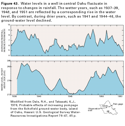
In the Schofield area of central Oahu, where ground-water withdrawals have generally been small relative to recharge, ground-water levels fluctuate mainly in response to changes in rainfall (fig. 43). The water-level response generally lags the averaged rainfall by several months to a year.
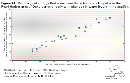
Spring discharge is related to aquifer water levels. The discharge of springs that issue from the volcanic-rock aquifer in the Pearl Harbor area of Oahu (fig. 44) varies directly with changes in the water level (hydraulic head) in the aquifer. When the water level in the aquifer is highest, spring discharge is greatest, and, conversely, when the water level is lowered, spring discharge decreases.
Ground-Water Quality
The source of fresh ground water in Hawaii is precipitation that
originates as water evaporated from the surrounding ocean. The
water vapor condenses on salt nuclei in the atmosphere, which
are also commonly of oceanic origin. Accordingly, the rain that
falls on the islands contains diluted concentrations of the same
ions as those in seawater; the rainfall is particularly enriched
with sodium and chloride, the major components of seawater. Even
on days when no rainfall occurs, small concentrations of ocean
salts accumulate on the land surface because the salts are transported
as aerosols carried ashore by prevailing winds. These conditions
account for the fact that most ground water in the Hawaiian islands,
even in high-altitude recharge areas, contains sodium and chloride
as the dominant ions.
The rainfall is altered naturally when it partly dissolves volcanic rocks and sedimentary deposits as the water moves in the subsurface from interior areas to discharge areas near the ocean. The water acquires calcium, magnesium, sodium, silica, and iron from volcanic rocks and alluvium. The water acquires bicarbonate and calcium as it infiltrates the consolidated sedimentary deposits especially where these deposits are calcareous.
In general, salinity of ground water in the Hawaiian islands decreases with distance inland from the coast and increases with depth in the aquifer. Elevated concentrations of sodium and chloride in ground water in nearshore rocks generally are the result of mixing of fresh ground water with saltwater derived from the ocean. These mixing effects are most pronounced in aquifers with highly permeable rocks exposed at the ocean floor because saltwater can readily flow into such aquifers. In addition, elevated concentrations of sodium and chloride in ground water may reflect a low recharge rate. In some of the western parts of the island of Hawaii, for example, a freshwater lens does not exist: only brackish water overlies saltwater in the highly permeable volcanic-rock aquifer because of both low recharge and lack of a coastal caprock. Water in coralline limestone along the southern coast of Oahu is also generally brackish because recharge is low and because highly permeable limestone crops out at the ocean floor, allowing easy inflow of saltwater.
When water is withdrawn from a freshwater lens, the freshwater lens shrinks and saltwater will encroach or intrude into parts of the aquifer that formerly contained freshwater. The degree of saltwater intrusion depends on several factors, which include the hydraulic properties of the rocks, recharge rate, and pumping rate. The effect of intrusion on a particular well depends on the vertical and lateral distance between the well and the transition zone.
In the Honolulu area of Oahu, some free-flowing artesian wells that originally produced fresh ground water were later abandoned because of increased salinity associated with saltwater intrusion. Pumping from a well can cause the freshwater-saltwater transition zone to rise into the pumped well. Many wells in Hawaii that are pumped at high rates or drilled too deeply are affected by this process, resulting in increased concentrations of sodium and chloride in pumped water.
Ground water is chemically altered as a result of human activities in developed areas. Shallow, unconfined aquifers are most susceptible to contamination through the land surface, especially where infiltration of water from the surface rapidly recharges the aquifers. Even deeply buried aquifers are not immune to contamination. In general, areas that receive large amounts of rainfall or irrigation water and that have highly per- meable soils are susceptible to ground-water contamination.
Sources of ground-water contamination that result from human activities are classified as point or nonpoint. Point sources are specific local sites from which pollutants are discharged. Common types of point sources are cesspools, disposal wells, landfills, industrial sites, and underground storage tanks. Nonpoint sources extend over broad areas and include agricultural fields treated with pesticides or fertilizers and residential areas where chemicals are used near homes and on lawns. Human activities associated with agricultural, industrial, and residential areas can have profound effects on the quality of water in affected aquifers.
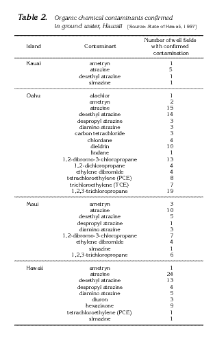
Since the early 1980's, organic-chemical contaminants associated with agricultural, industrial, and urban activities have been detected in water samples from wells in the State (fig. 45; table 2). The chemicals 1,2-dibromo-3-chloropropane (DBCP), 1,2-dibromoethane or ethylene dibromide (EDB), and 1,2,3-trichloropropane (TCP), which are associated with nematicides previously used in pineapple cultivation in Hawaii, have been detected in ground-water samples from wells on the islands of Oahu and Maui. Locations of contaminated well sites are in or downgradient from areas of past and present pineapple cultivation. EDB contamination on Oahu also may be associated with fuel pipeline leaks. Concentrations of DBCP in water samples are generally less than 200 nanograms per liter, EDB less than 50 nanograms per liter, and TCP less than 3,000 nanograms per liter. Concentrations of contaminants vary with time in response to changes in pumping rates, recharge rates, and the timing of the chemical applications. Granular activated carbon filters are being used on Oahu and an aeration system is being used on Maui to treat contaminated water before distribution.
On the islands of Hawaii, Maui, Oahu, and Kauai, the herbicides atrazine and ametryn, which are associated with sugarcane cultivation, have been detected in wells within or downgradient from areas of past and present sugarcane cultivation. Concentrations of atrazine and ametryn in water samples are generally less than 1,000 nanograms per liter. Other chemicals associated with agricultural activities that have been detected to a lesser spatial extent include the herbicides alachlor, simazine, diuron, and hexazinone.
Chemicals associated with non-agricultural activities have also been detected in water samples, primarily on the island of Oahu. In the urbanized Honolulu area, for example, pesticides such as chlordane and dieldrin have been detected in ground-water samples. Prior to being banned in 1988, chlordane was the most popular pesticide used in Hawaii for termite treatments around homes. Concentrations of chlordane and dieldrin are generally less than 300 and 100 nanograms per liter, respectively. Solvents such as trichloroethylene (TCE), tetrachloroethylene (PCE), and carbon tetrachloride have been detected in ground-water samples mainly in Honolulu and central Oahu. In central Oahu, an aeration system is used to treat ground water contaminated with TCE and PCE.
The extent of ground-water contamination by organic chemicals in Hawaii may not be fully known at this time. As more wells are sampled, more chemical analyses are performed, and better analytical equipment and methods become available, the spatial extent of the contamination can be better identified.
Geothermal Water
Geothermal water can be an important water resource in the Hawaiian
islands. At present (1998), however, the only geothermal water
actively being developed is in the eastern part of the island
of Hawaii, where steam from geothermal wells is used to generate
about 25 megawatts of electrical power. The wells are drilled
in the east rift zone of Kilauea Volcano near eruptive vents that
were active in 1955. Wells have encountered elevated water temperatures
near Lihue on Kauai, near the caldera of Waianae Volcano and near
Kailua on Oahu, near the summit of West Molokai Volcano on Molokai,
near the summit of Lanai Volcano, near Lahaina on Maui, and near
Kawaihae on the island of Hawaii.
Fresh Ground-Water Withdrawals
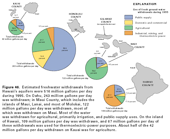
Ground water is an important resource in the State of Hawaii.
During 1995, ground water supplied about 51 percent, or about
516 million gallons per day, of the estimated total freshwater
used. About 47 percent of the total ground water withdrawn (243
million gallons per day) was on Oahu (fig.
46). Ground-water withdrawals in Maui County totaled 122 million
gallons per day. The State of Hawaii, which regulates the development
and use of ground water, has designated parts of Oahu and the
entire island of Molokai as ground-water management areas. Within
these areas, the State is authorized to manage ground-water withdrawals
through a permitting process.
Fresh ground-water withdrawals on the island of Hawaii during 1995 were about 109 million gallons per day (fig. 46). About 62 percent of the total withdrawn, or about 67 million gallons per day, was used for industrial, mining, and thermoelectric-power purposes; more than 99 percent of this 67 million gallons per day was used for thermoelectric-power purposes. Withdrawals for public supply were about 23 million gallons per day. Withdrawals for agricultural use were about 13 million gallons per day, and withdrawals for domestic and commercial uses were about 6 million gallons per day.
In Maui County, which includes the islands of Kahoolawe, Lanai, Maui, and most of Molokai, the total fresh ground-water withdrawals during 1995 were about 122 million gallons per day. About 93 percent of the 122 million gallons per day was withdrawn on the island of Maui. For Maui County during 1995, the largest withdrawals, about 77 percent (94 million gallons per day), were for agricultural irrigation. Withdrawals for domestic and commercial uses amounted to about 5 million gallons per day, and public-supply withdrawals were about 22 million gallons per day. Industrial, mining, and thermoelectric-power withdrawals were about 1 million gallons per day.
The total fresh ground-water withdrawal on Oahu during 1995
was about 243 million gallons per day, which nearly equaled the
total withdrawn on all the other islands. Public-supply withdrawals
accounted for the greatest amount of ground water pumped and amounted
to about 142 million gallons per day. Withdrawals for agricultural
purposes were about 53 million gallons per day. About 35 million
gallons per day was withdrawn for domestic and commercial supplies,
and about 13 million gallons per day was withdrawn for industrial,
mining, and thermoelectric-power uses.
Total fresh ground-water withdrawals on Kauai during 1995 were
about 42 million gallons per day, about one-half of which (about
21 million gallons per day) was pumped for agricultural purposes.
Public-supply withdrawals were about 14 million gallons per day.
Withdrawals for industrial purposes were about 5 million gallons
per day, and the remaining 2 million gallons per day was pumped
for domestic and commercial purposes. No water was used for mining
or thermoelectric-power generation. Water-use data were unavailable
for the island of Niihau.
Historically, ground-water used for agricultural irrigation has been highest on the island of Oahu, where large amounts of water were needed for sugarcane cultivation. By October 1996, however, the last remaining sugarcane plantation on Oahu harvested its final crop. In 1995, the amount of ground water withdrawn for agricultural use on Oahu was about 53 million gallons per day, and in Maui County, where sugarcane is extensively grown in areas that receive little rainfall, ground-water withdrawn for agricultural irrigation was about 94 million gallons per day.