|
The topographically defined Black Hills and adjacent areas (Black Hills area) of Wyoming (fig. 1) are underlain by two regionally important aquifers-the Minnelusa and the Madison. The Minnelusa aquifer is used extensively in the Black Hills area as a source of domestic and livestock water. The Madison aquifer is an important source of municipal, industrial, agricultural, and domestic water in both the Black Hills area and other parts of Wyoming. Increased demand for water from the Minnelusa and Madison aquifers in the Black Hills area of Wyoming and South Dakota have created a need for better understanding of the hydrology of these two important aquifers. This report presents information on the potentiometric surfaces and altitudes of the tops of the Minnelusa and Madison aquifers in the Black Hills area of northeastern Wyoming using new data collected since completion of earlier studies. In addition, ground-water levels in selected wells are examined, and the relative age of a limited number of ground-water samples are discussed. The information will be of use to government officials, land planners and other individuals who must manage the limited water resources of this growing and developing area. The scope of the project was limited to wells and springs in the Black Hills area of Wyoming. Water levels were measured during 1998 and 1999 in wells completed in the Minnelusa and Madison aquifers to construct potentiometric-surface maps. The potentiometric surfaces and altitudes of the tops of the Minnelusa and Madison aquifers were contoured at the same scale (1:100,000) as studies of the aquifers recently conducted by the U.S. Geological Survey (USGS) in the Black Hills area within South Dakota (Carter and Redden, 1999a, 1999b; Strobel and others, 2000a, 2000b). The contours in these studies of the Minnelusa and Madison aquifers in South Dakota were "edge matched" as closely as possible along the Wyoming-South Dakota State line using the same contour interval. Use of the same contour interval and edge matching will allow for the use of the maps across State boundaries and improve understanding of the aquifers in a larger area within the Black Hills uplift. In places, some contours could not be matched across the Wyoming-South Dakota State line because this investigation was completed after the South Dakota investigations, and additional control points used in this investigation were located in Wyoming near the State line. The reader should note that Minnelusa and Madison outcrop areas and some structural features may not match in some areas along the Wyoming-South Dakota State line when maps in this study area are aligned or "edge matched" with maps produced for the South Dakota studies because different sources of geological mapping were used for the studies. Ground-water samples were collected from a subset of measured wells and analyzed for tritium to qualitatively estimate the time of ground-water recharge. This project was conducted by the USGS in cooperation with the Wyoming State Engineer's Office (WSEO). The study area was almost entirely within Crook and Weston Counties in Wyoming and was bordered on the east by the Wyoming-South Dakota State line. |
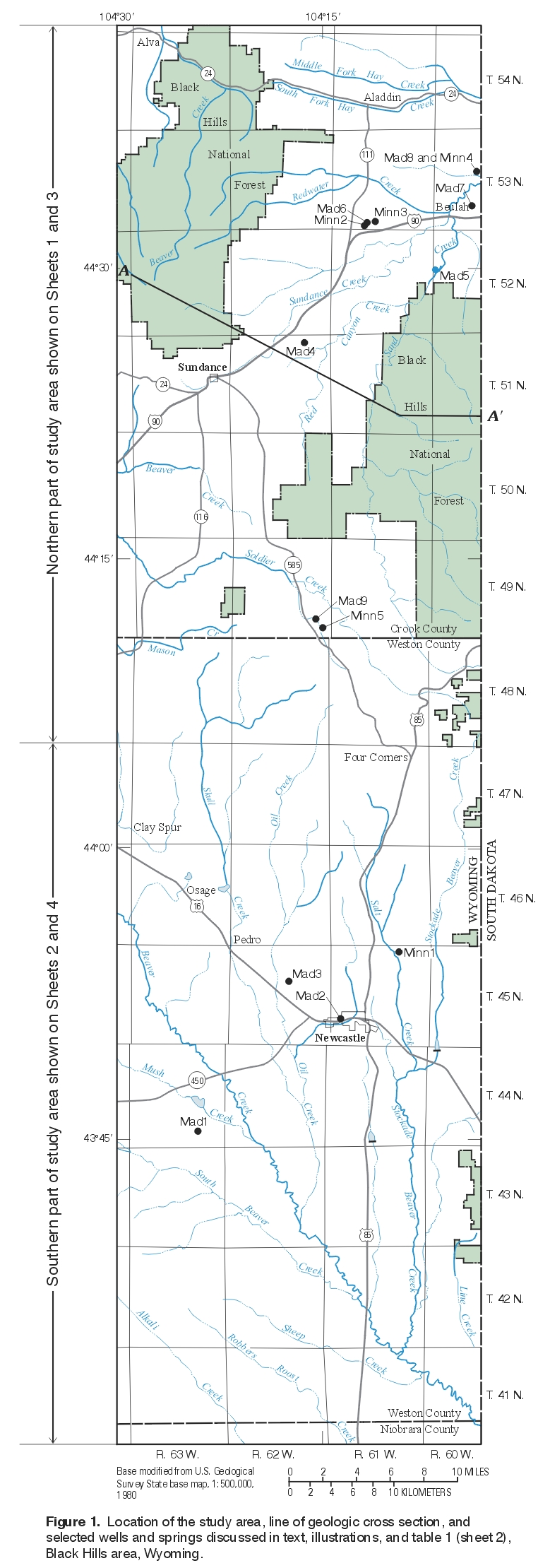
Figure 1. Location of the study area, line of geologic cross section, and selected wells and springs discussed in text, illustrations, and table 1, Black Hills area, Wyoming. (Click on image for a larger version, 562kb) |
Investigations of the geology or hydrogeology of the Minnelusa and Madison aquifers in the Black Hills area have been conducted for about a century. The earliest known investigations are: Newton and Jenney, 1880; Darton, 1904, 1905, 1909; and Darton and O'Harra, 1905, 1907. The hydrogeologic investigations typically were conducted at two different scales-local and regional; the different scale of investigation often resulted in different interpretations of the characteristics of the Minnelusa and Madison aquifers by different investigators. Local investigations typically were conducted within an individual State's political boundary or within a specific geographic area (e.g., Black Hills area in Wyoming and South Dakota), while regional investigations typically were conducted in several States and interpreted the characteristics of the Minnelusa and Madison aquifers in relation to large regional aquifer systems comprising many aquifers. Many local and regional investigations describe the Minnelusa and Madison aquifers not only in the Black Hills area, but also in the adjacent Powder River Basin.
The name Powder River Basin commonly is used to identify both the drainage basin and the structural basin. In this report, all use of Powder River Basin will refer to the structural basin.
Most hydrogeologic investigations that include the Black Hills area in Wyoming emphasized the Madison aquifer, with comparatively little study of the Minnelusa aquifer. In some of these investigations, the Madison aquifer in the Powder River Basin and Black Hills area is defined as comprising not only rocks of the Madison Limestone, but also rocks suspected by the investigators to be in hydraulic connection with the Madison Limestone (Crist and Lowry, 1972; Swenson, 1974; Huntoon, 1976; Swenson and others, 1976). Earlier (prior to this investigation) potentiometric maps showing the direction of ground-water flow in the Madison aquifer or Madison aquifer and equivalent rocks in the Powder River Basin and Black Hills area within Wyoming and parts of surrounding States (i.e., surrounding parts of Montana and/or South Dakota) are presented in reports by Swenson (1974), Wyoming State Engineer's Office (1974), Swenson and others (1976), and Kyllonen and Peter (1987). Physical and hydraulic characteristics of the Minnelusa and Madison aquifers in the Black Hills area of Wyoming are discussed in Whitcomb and Morris (1964), Hodson and others (1973), Hodson (1974), Swenson (1974), Wyoming State Engineer's Office (1974, 1976), Blankennagel and others (1977), Kelly and others (1981), Feathers and others (1981), and Lowry and others (1986). Fitzwater (1981) examined the hydrogeology and geochemistry of the Minnelusa and Madison aquifers in northeastern Wyoming, including parts of the study area. The relationship between streamflow gains and losses and interaction with the Minnelusa and/or Madison aquifers in the Powder River Basin and Black Hills area in Wyoming was studied at selected streamflow-measurement sites in reports by the Wyoming State Engineer's Office (1974, 1976), Boner and others (1976), and Glass and Sultz (1992).
In contrast, both the Minnelusa and Madison aquifers were included in many local investigations of the aquifers in the Black Hills area of South Dakota. Many of these investigations were conducted by the USGS as part of a long-term study begun in 1990 in cooperation with the South Dakota Department of Environment and Natural Resources and the West Dakota Water Development District, which represents many local and county cooperators (Driscoll, 1992). The Minnelusa and Madison aquifers examined in these investigations are the same or very similar to aquifers present in Wyoming, and the aquifers usually are in direct hydraulic connection across the Wyoming-South Dakota State line; therefore, these investigations are important to understanding the characteristics of the Minnelusa and Madison aquifers in Wyoming. The reader is referred to Greene (1993), Greene and Rahn (1995), Hortness and Driscoll (1998), Greene and others (1999), Anderson and others (1999), Carter and Redden (1999a; 1999b), Strobel and others (1999), Strobel and others (2000a; 2000b), Carter and others (2001a; 2001b), and Driscoll and Carter (2001) for relevant local investigations of the hydrology of the Minnelusa and Madison aquifers in the Black Hills area of South Dakota. Kyllonen and Peter (1987) studied the hydrology of the Minnelusa and Madison aquifers in the Black Hills area of both Wyoming and South Dakota, including parts of the study area. The geochemistry of the Minnelusa and Madison aquifers in the Black Hills area of South Dakota was recently described in Naus and others (2001). Selected results from many of these studies are briefly discussed herein.
Many regional investigations of the Minnelusa and Madison aquifers were conducted by the USGS as part of the Madison Limestone study begun in 1975 (U.S. Geological Survey, 1975) and the Northern Great Plains Regional Aquifer-System Analysis (RASA) study started in the late 1970's (U.S. Geological Survey, 1979). In addition to collection of new data, these regional investigations also used information from many of the local-scale investigations previously discussed. The reader should note that the investigators commonly defined the Minnelusa and Madison aquifers as part of an aquifer system comprising not only the Minnelusa Formation and Madison Limestone, but also other formations believed to be equivalent to or in hydraulic connection with the formations in Wyoming, Montana, North Dakota, and South Dakota. Potentiometric maps constructed during these studies are regional in scope and show the direction of ground-water flow in the Minnelusa and Madison aquifers and equivalent rocks in the Powder River Basin and Black Hills area within Wyoming, Montana, North Dakota, and South Dakota (Miller and Strausz, 1980; Downey, 1984; Downey and Dinwiddie, 1988). Physical and hydraulic characteristics of the Minnelusa and Madison aquifers and associated rocks were described in Sando (1976a, 1976b), Peterson (1978, 1984), MacCary and others (1983), Thayer (1983), Brown and others (1984), Downey (1984, 1986), MacCary (1984), Lobmeyer (1985), Cooley and others (1986), and Downey and Dinwiddie (1988). In addition, the geochemistry of the Madison aquifer is discussed in Hanshaw and others (1978), Plummer and Back (1980), Back and others (1983), Busby and others (1983), Plummer and others (1990), Busby and others (1991), and Busby and others (1995).
|
The Black Hills uplift is an asymmetric dome (anticlinal upwarp) in Wyoming, South Dakota, and Montana that was formed about 60 to 65 million years ago during the Laramide orogeny. The uplift trends north-northwest, is about 175 miles long and 90 miles wide, and is bounded by monoclines on the west and east (DeWitt and others, 1986). Erosion has exposed outcrops of shallow marine to nearshore-terrestrial Paleozoic and Mesozoic sedimentary rocks (commonly as hogback ridges) that encircle Precambrian igneous and metamorphic rocks that form the core (fig. 2) of the Black Hills. The sedimentary rocks dip away from the igneous and metamorphic core and are locally interrupted by monoclines, folds, faults, and Tertiary igneous intrusions. The slopes of the dome structure of the uplift are gentler on the western side (Wyoming) than on the eastern side (South Dakota). Two blocks comprise the Black Hills uplift: a western, structurally lower block bounded on the west by the Black Hills monocline and bounded on the east by the Fanny Peak monocline, and an eastern, structurally higher block bounded on the east by a homoclinal dip slope and bounded on the west by the Fanny Peak monocline (Lisenbee, 1978, 1985). The Fanny Peak monocline separates the two blocks. The Black Hills and Fanny Peak monoclines are shown on the maps on sheets 2 and 4. |

Figure 2. Geologic cross section. Line of geologic cross section shown in
figure 1. |
The authors thank Richard G. Stockdale (WSEO) for support of this study and residents of the study area who provided access to their property, wells, and springs, and shared their knowledge of the study area. Jon P. Mason (USGS) and Larry Porter (WSEO) are thanked for assistance in preparation of water-level hydrographs and Kirk A. Miller (USGS) is thanked for assistance in preparation of figures showing topographic and precipitation information. Suzanne C. Roberts (USGS) is thanked for preparation of illustrations and report layout, and Emily A. Sabado (USGS) is thanked for editorial assistance.
Wells for this investigation were selected from monitor and water-supply wells (stock, domestic, irrigation, and municipal) that were visited by the USGS or permitted by the WSEO. The monitor wells either had been installed to measure water levels or had been converted to monitoring use. Permitted wells within the study area were evaluated to select only wells completed in the Minnelusa or Madison aquifers by comparing well logs filed at the WSEO to published geological information. Permit holders of selected wells then were contacted to obtain permission to measure water levels and possibly to collect a ground-water sample for tritium analysis. Well locations and other ancillary information on the well permits were verified when the wells were visited.
Water levels were measured in the monitor wells and the water-supply wells. Water-level measurements from wells instrumented with continuous water-level recording devices were obtained from the WSEO. Each monitor well was visited at least once. Water levels were measured using a steel tape, an electrical tape, or a pressure gauge. If a water level could not be measured in a well because of well construction, or if a landowner prohibited access to a well, water-level measurements were obtained from either the landowner, USGS records, or WSEO well permits. Water levels measured above or below land surface were converted to water-level altitudes above sea level; water-level altitudes also are known as hydraulic heads. The distribution of hydraulic head in an aquifer is shown by construction of a potentiometric-surface map.
Potentiometric surfaces (sheets 1 and 2) were mapped by contouring altitudes of water levels measured in wells completed in the Minnelusa and Madison aquifers and altitudes of springs originating from the Minnelusa aquifer. The potentiometric surfaces of both aquifers were constructed using water levels measured in wells completed at different depth intervals within the aquifer and measured at different times and therefore are considered to be generalized potentiometric surfaces. Most water levels were measured during the fall of 1998 and 1999. Earlier water-level measurements were used in some areas to improve data density and spatial distribution. The water-level altitudes shown on the maps are from the ground-water database of the USGS National Water Information System, and the spring altitudes are from published USGS topographic maps. Ranges in measured water levels for continuous-recording wells generally are less than the 100-foot contour interval used; thus, in most areas the configuration of the potentiometric surface during the period of water-level data collection (about 1955 to 1999) probably is not very different from that which is shown. Potentiometric contours are dashed where inferred or approximated. Many wells are completed in the upper 200 to 300 feet of the Minnelusa aquifer, but wells locally are completed in sandstone beds in the middle to lower parts of the aquifer. The depth of wells completed in the aquifer is not shown on the maps. Most of the springs used in contouring are on or near the outcrop area. The actual hydraulic head in the vicinity of the springs probably is higher than the spring altitudes.
Structural contours showing the altitudes of the tops of the Minnelusa and Madison aquifers (sheets 3 and 4) were constructed by modifying and updating contours presented in Head and others (1979). The contours from Head and others (1979) were scanned and used as a starting point for construction of contours of the tops of both aquifers. The contours then were modified and updated, primarily on the basis of additional lithologic information (well logs) obtained from the ground-water database of the USGS National Water Information System, paper records on file in the USGS office in Cheyenne, and with structural contour maps for both the Minnelusa Formation and Madison Limestone in Kyllonen and Peter (1987) and the Minnelusa Formation in Fox and Higley (1987) and Crysdale (1990).
The reader should note that potentiometric-surface and structural contours in this report are presented using the National Geodetic Vertical Datum of 1929 and the topographic contours are presented using the North American Vertical Datum of 1988; comparison of the two vertical datums at different locations within the study area indicate a maximum difference between the two of about two feet in altitude. This difference is considered sufficiently accurate for purposes of this investigation, especially when the intervals of the potentiometric contours (100 ft) and land surface contours (200 ft) are considered in relation to the structural contours (1,000 ft). However, the reader should note this discrepancy when using the contours for other purposes.
Water samples were collected from selected springs and wells and analyzed for tritium. Samples were collected from wells after three well-casing volumes were removed by pumping and after successive measurements of pH, specific conductance, and temperature had stabilized. Samples from springs were collected as close as possible to the discharge point of the spring to minimize contact with the atmosphere. Tritium samples were collected by completely filling 1-liter polyethylene bottles after rinsing the bottles and polyseal caps three times with the water being sampled. The tritium samples were analyzed at the USGS laboratory in Menlo Park, California.
Tritium is a radioactive isotope of hydrogen present in water molecules with a half-life of about 12.43 years (Plummer and others, 1993). Tritium is produced naturally in the Earth's atmosphere at very low concentrations; however, the atmospheric testing of large thermonuclear devices from 1952 through 1964 added large amounts of tritium to the atmosphere, up to several orders of magnitude above levels produced naturally (Clark and Fritz, 1997). The concentration of tritium in ground-water samples can be used to qualitatively estimate the time at which water that originated as precipitation recharged the part of the aquifer sampled and then was isolated from the atmosphere. Natural levels of tritium in continental precipitation prior to bomb testing probably ranged between 1 and 20 tritium units (TU) (Kaufman and Libby, 1954). Ground water derived exclusively from precipitation before thermonuclear device testing would have maximum concentrations of about 0.2 to 0.8 TU by the early 1990's because of radioactive decay (Plummer and others, 1993; Clark and Fritz, 1997). Higher concentrations of tritium suggest that some fraction of the ground water sampled probably was recharged since 1953. Tritium samples discussed in this report were collected during this study and an earlier study conducted by the WSEO and USGS.
In this report, the Minnelusa aquifer is defined as equivalent to the Minnelusa Formation. The Minnelusa aquifer is used more than the Madison aquifer for domestic and stock wells in the study area. The Minnelusa aquifer outcrop is exposed at the land surface throughout much of the study area, primarily at higher altitudes near the Wyoming-South Dakota State line.
The Minnelusa aquifer (Pennsylvanian and Lower Permian) is unconformably overlain by the Opeche Shale (Permian) and unconformably underlain by the Madison Limestone (Mississippian) (DeWitt and others, 1986, 1989; Love and others, 1993). The Opeche Shale is believed to be a confining unit where the Minnelusa aquifer is saturated in Wyoming and South Dakota (Strobel and others, 1999). In the South Dakota part of the Black Hills, the Minnelusa Formation is sometimes considered to be an aquifer in the upper part and a confining unit in the lower, primarily because of differences in lithology in the upper and lower parts of the formation (Strobel and others, 1999; Epstein, 2001). It is unclear if the Minnelusa aquifer in Wyoming can be defined in a similar manner, but differences in hydraulic head observed in this study between wells completed in the Minnelusa Formation and Madison Limestone in the study area may support this conclusion in some areas of the Black Hills within Wyoming. Recharge to the Minnelusa aquifer in Wyoming and South Dakota in the Black Hills area is primarily from infiltration of precipitation on outcrops and from streamflow losses where streams cross the outcrop areas (Downey and Dinwiddie, 1988; Hortness and Driscoll, 1998; Carter and others, 2001a, 2001b).
The Minnelusa aquifer in the Black Hills of Wyoming and South Dakota consists primarily of alternating sandstone and dolomite units interbedded with lesser amounts of shale and chert (DeWitt and others, 1986). In the western Black Hills (includes the study area), DeWitt and others (1986, fig. 4, p. 11) report a thickness of 700-1,000 ft for the Minnelusa aquifer. The upper part of the Minnelusa Formation "contains dolomite, anhydrite, eolian sandstone, siltstone, and cherty dolomite" whereas the lower part of the formation "consists of shale, dolomite, radioactive black shale, anhydrite, and sandstone" (DeWitt and others, 1986, p. 35). The anhydrite beds common in the upper part of the formation commonly become solution breccias in outcrop (DeWitt and others, 1986; Epstein, 2001). Epstein (2001) also noted that gypsum (in addition to anhydrite) also commonly is present in the upper part of the Minnelusa Formation in the northern Black Hills. Some investigators (DeWitt and others, 1986; Epstein, 2001) have noted that the gypsum and anhydrite interbedded with the sandstone is much more common in the upper part of the formation and commonly characterizes the upper part of the Minnelusa Formation in the Black Hills; consequently, and as noted earlier, some investigators define the upper part of the Minnelusa Formation as an aquifer and the lower part as a confining unit in the Black Hills (Kyllonen and Peter, 1987; Greene, 1993; Strobel and others, 1999).
Although primary porosity and permeability in the Minnelusa aquifer occur where the aquifer consists mainly of sandstones, substantial secondary porosity and permeability occur where the aquifer consists mainly of carbonate rocks (dolomite and limestone) and calcium sulfate rocks (gypsum and anhydrite). Natural dissolution processes associated with karstification have developed or enlarged fractures and other openings in the carbonate and calcium sulfate rocks (Strobel and others, 1999; Epstein, 2001). Large well yields reported for wells completed in the Minnelusa aquifer are believed to be from these zones within the aquifer where secondary porosity and permeability have developed as a result of dissolution or fractures. Epstein (2001, p. 31) reports that gypsum and anhydrite "comprise about 30 percent of the Minnelusa Formation" in the northern Black Hills and notes that both primarily are present in the subsurface (and more commonly in the upper part of the Minnelusa Formation) because most anhydrite at the outcrop has been removed by dissolution (except areas in Wyoming near Beulah and Sundance and some areas in South Dakota). Epstein (2001, p. 30) also noted that "calcium sulfate rocks are much more soluble than carbonate rocks, especially where they are associated with dolomite undergoing dedolomitization, a process which results in ground water that is continuously undersaturated with respect to gypsum." In some locations in the Black Hills area, dissolution of gypsum and anhydrite in the Minnelusa aquifer has affected the hydrologic characteristics of the aquifer and hydrogeologic units above; sinkholes and other collapse features are commonly filled with breccias (Bowles and Braddock, 1963; Braddock, 1963; Epstein, 2001). Therefore, areas in the Minnelusa aquifer with calcium sulfate rocks may be more susceptible to continuing karstic development through dissolution than areas with only carbonate rocks (dolomite and/or limestone).
Structural contours showing the configuration and altitude of the top of the Minnelusa aquifer constructed for this and earlier investigations (Head and others, 1979; Fox and Higley, 1987; Kyllonen and Peter, 1987; Crysdale, 1990) show that the Minnelusa aquifer dips away from uplift areas (Black Hills and Bear Lodge Mountains). Structural contours constructed during this investigation for the northern part of the study area (sheet 3) range from about 6,000 ft above sea level in the southeast to about 2,000 ft above sea level in the north. In the southern part of the study area (sheet 4), structural contours range from about 5,000 feet above sea level in the northeast to about 3,000 feet below sea level in the southwest.
The potentiometric surface constructed for this study (sheets 1 and 2 ) shows ground water in the Minnelusa aquifer generally flows radially outward (primarily to the west) and generally downdip from the outcrop area of the aquifer along the eastern part of the study area. Earlier potentiometric surfaces constructed for the Minnelusa aquifer in South Dakota (Strobel and others, 2000a) or for the Minnelusa aquifer and equivalent rocks in Wyoming, South Dakota, and Montana (Kyllonen and Peter, 1987; Downey and Dinwiddie, 1988, fig. 19, p. A23) suggest similar movement in the study area. These studies also show that ground water in the Minnelusa aquifer in Wyoming and South Dakota immediately in the vicinity of the Black Hills generally flows radially outward from the aquifer outcrop areas that encircle the center part of the uplift (igneous and metamorphic core). The location of outcrop areas, in combination with higher precipitation in upland areas and radial ground-water flow away from these areas, supports the hypothesis stated previously that the primary sources of recharge to the Minnelusa aquifer are precipitation on outcrops and streams crossing outcrops. In the western part of the northern part of the study area (vicinity of the Bear Lodge Mountains), contours constructed during this study indicate ground water in the Minnelusa aquifer primarily flows to the east.
In the northern part of the study area (sheet 1), the altitude of the potentiometric surface ranged from about 6,400 ft above sea level in the southeast near the Wyoming-South Dakota State line to about 3,500 ft above sea level in the northeast near the Wyoming-South Dakota State line. In the southern part of the study area (sheet 2), contours were constructed only for the northeast, and the altitude of the potentiometric surface ranged from about 6,000 ft to about 4,700 ft above sea level.
Water LevelsWater levels in the Minnelusa aquifer generally increased during 1995-99, a period of above-average precipitation. The hydrograph for well Minn2 (fig. 3) illustrates this point.TritiumTritium concentrations in three ground-water samples collected from the Minnelusa aquifer during this and an earlier study are listed in table 1. In two of the three wells, tritium concentrations (well Minn2, 8.3 TU, and well Minn3, 4.4 TU) suggest at least some of the water sampled in these wells was recharged since 1953. The tritium concentration in one of three wells sampled (well Minn1, <0.8 TU) suggests water sampled from the well was recharged prior to 1953. |
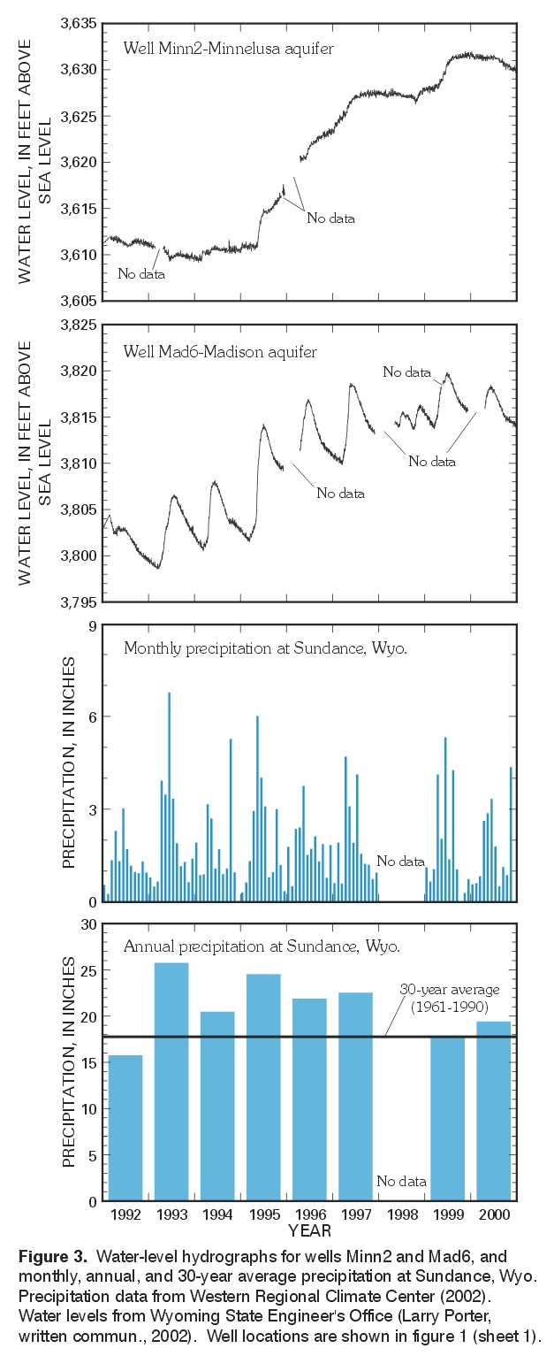
Figure 3. Water-level hydrographs for wells Minn2 and Mad6, and monthly, annual, and 30-year average precipitation at Sundance, Wyo. Precipitation data from Western Regional Climate Center (2002). Water levels from Wyoming State Engineer's Office (Larry Porter, written commun., 2002). Well locations are shown in figure 1. (Click on image for a larger version, 248kb) |
Table 1. Tritium concentrations in ground-water samples collected from selected wells and springs
[<, less than]
| Map identification number and site type (fig. 1) |
U.S. Geological Survey station identification number |
Aquifer | Sample collection date |
Tritium concentration and analytical uncertainty, in tritium units (TU) |
|---|---|---|---|---|
| Minn1 (well) | 435433104092701 | Minnelusa | 7/22/99 | <0.8 ± 0.6 |
| Minn2 (well) | 443158104114202 | Minnelusa | 10/31/91 | 8.3 ± 0.8 |
| Minn3 (well) | 443213104110601 | Minnelusa | 8/18/99 | 4.4 ± 0.8 |
| Mad1 (well) | 434539104233401 | Madison | 7/29/99 | <0.8 ± 0.6 |
| Mad2 (well) | 435115104131701 | Madison | 7/20/99 | <0.8 ± 0.6 |
| Mad3 (well) | 435324104173101 | Madison | 7/23/99 | <0.8 ± 0.6 |
| Mad4 (well) | 442601104155201 | Madison | 10/31/91 | 24.1 ± 1.6 |
| Mad5 (spring) | 442927104063201 | Madison | 8/17/99 | 13.7 ± 1.0 |
| Mad6 (well) | 443158104114201 | Madison | 10/29/91 | 2.3 ± 0.6 |
| Mad7 (well) | 443300104040601 | Madison | 8/19/99 | <0.8 ± 0.6 |
| Mad8 (well) | 443456104032301 | Madison | 10/30/91 | <0.8 ± 0.6 |
| Average annual precipitation is affected by land-surface altitude in the study area (precipitation data for Sundance, Wyoming are shown in figure 3 and average annual precipitation and land-surface altitude are shown in 4). Areas with the highest precipitation in the study area (fig. 4) coincide with much of the outcrop of the Minnelusa aquifer (sheets 1 and 2 ). Consequently, it might be expected that these areas may receive more recharge than other areas (if hydrogeologic conditions allow), and samples collected in these areas are more likely to have tritium concentrations indicative of recharge since 1953 (greater than about 0.8 TU). Carter and others (2001a, fig. 17, p. 54) showed that recharge to the Minnelusa and Madison aquifers is highest near outcrop areas. As just discussed, tritium concentrations in ground-water samples collected from two of three wells completed in the Minnelusa aquifer indicate some recharge since 1953; both wells with tritium concentrations greater than 0.8 TU were close to outcrop areas of the Minnelusa aquifer that coincide with areas of high precipitation. It is unclear if the higher concentrations of tritium in these two wells (Minn2, Minn3) are related to close proximity to the Minnelusa outcrop (and higher amounts of precipitation) or because of limited sample size (only one sample was collected from a well (Minn1) outside areas where the Minnelusa outcrop coincides with high precipitation). | 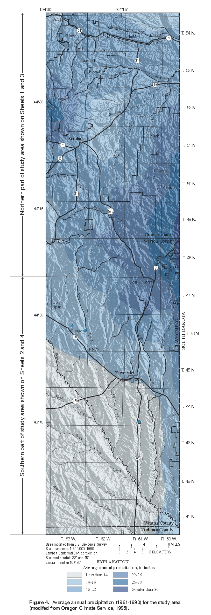
Figure 4. Average annual precipitation (1961-1990) for the study area (modifed from Oregon Climate Service, 1995). (Click on image for a larger version, 1.02mb) |
In this report, the Madison aquifer is defined as equivalent to the Madison Limestone. The reader should note that the Madison Limestone is considered equivalent to the Pahasapa Limestone by most investigators and for purposes of this study. In many areas in Wyoming, large quantities of high-quality water, sometimes under artesian pressure, can be obtained from the Madison aquifer. In the Black Hills of Wyoming and South Dakota, high yields are reported for wells completed in the Madison aquifer, so the aquifer is used when high yields are needed, primarily by municipalities, subdivisions, rural water systems, irrigators and petroleum companies (for secondary oil recovery). Most of the outcrop of the Madison aquifer in the Black Hills is located in South Dakota, so most of the recharge to the aquifer is likely to occur in South Dakota. For mapping purposes, the Madison Limestone was combined with the underlying Englewood Formation by DeWitt and others (1989). The mapped outcrop areas for the Madison aquifer presented in this report are from DeWitt and others (1989), so the reader should note that the outcrop areas probably indicate more of the Madison aquifer at the land surface than is actually present. Most of the available data characterizes the upper part of the Madison aquifer.
The Madison aquifer (Lower Mississippian) in the Black Hills uplift is primarily composed of massive, gray to buff limestone that is locally dolomitic (DeWitt and others, 1986; Strobel and others, 1999). The thickness of the Madison Limestone varies throughout the Black Hills area, probably because of karst topography that developed prior to deposition of overlying formations (DeWitt and others, 1986). In the western Black Hills, DeWitt and others (1986, fig. 4, p. 11) report a thickness of 300-630 ft for the Madison Limestone. Primary permeability probably is low in the Madison aquifer because it is mainly composed of carbonate rocks; however, development of extensive secondary porosity and permeability from numerous fractures and solution openings accounts for the high yields of wells completed in the Madison aquifer in selected areas (Miller, 1976; Kelly and others, 1981; Kyllonen and Peter, 1987; Strobel and others, 1999). Dissolution of rocks in parts of the Madison aquifer has resulted in extensive past and ongoing development of karst solubility features and related secondary porosity and permeability (Sando, 1974). Numerous caves, fractures, and other karst features have been identified in the Madison aquifer in South Dakota and Wyoming, particularly the upper part (Sando, 1974; Peter, 1985; Kyllonen and Peter, 1987; Greene and Rahn, 1995). Greene and Rahn (1995) also noted that principal cavern development (and consequently, principal direction of transmissivity) in the Madison aquifer in the Black Hills area in South Dakota is oriented along the direction of ground-water flow. Porosity and permeability in the Madison aquifer in the Northern Great Plains appear to be higher in the crystalline dolomites than limestones comprising the aquifer (Thayer, 1983; Peterson, 1984). Large water yields have been reported for wells completed in more permeable zones of the Madison aquifer (probably where development of karst features has occurred) (Miller, 1976; Feathers and others, 1981; Kelly and others, 1981; Kyllonen and Peter, 1987); potential areas with high yields (more than 500 gallons per minute) from the Madison aquifer throughout the Northern Great Plains were discussed in MacCary and others (1983). Recharge to the Madison aquifer in the Black Hills area in Wyoming and South Dakota is primarily from infiltration of precipitation on outcrops and from streamflow losses (Swenson, 1968a, 1968b; Wyoming State Engineer's Office, 1974; Hortness and Driscoll, 1998; Carter and others, 2001a).
Springs discharging from the Madison aquifer provide flow for many streams in the study area (Wyoming State Engineer's Office, 1974, 1976; Boner and others, 1976; Glass and Sultz, 1992). In some areas, springs discharge near the contact of the Minnelusa and Madison aquifer.
Structural contours showing the configuration and altitude of the top of the Madison aquifer
(sheet 3) constructed for this and earlier investigations (Head and others, 1979; Kyllonen and Peter, 1987) show that the Madison aquifer, like the Minnelusa aquifer, dips away from uplift areas (Black Hills and Bear Lodge Mountains). Structural contours constructed during this investigation for the northern part of the study area range from about 6,000 ft above sea level to about 2,000 ft above sea level in most of the northern part of the study area; in the Bear Lodge Mountains area, the top of the aquifer is about 4,000 to 5,000 ft above sea level. In the southern part of the study area
(sheet 4), structural contours range from about 6,000 feet above sea level in the northeast to about 2,000 feet below sea level in the southwest.
Water from the Madison aquifer in the Black Hills area of Wyoming is used primarily for municipal (public) water supplies. Three communities within the study area, Newcastle, Osage, and Sundance (fig. 1), obtain all or part of their public water supply from the Madison aquifer (Sundance has a well completed in both the Minnelusa and Madison aquifers).
Municipal water withdrawals from the Madison aquifer in the Powder River Basin in Wyoming increased between 1973 and 1993, while industrial use decreased (Wyoming State Engineer's Office, 1993). The communities of Gillette, Upton, Newcastle, Pine Haven, Hulett, Sundance, Glenrock, Douglas, Osage, Kaycee, and Midwest use the Madison aquifer for some or all of their potable water supply. By 1993, these communities were withdrawing about twice the amount of water withdrawn in 1973. In contrast, water withdrawn from the Madison aquifer for industrial purposes, primarily secondary oil recovery, decreased from about 20,000 acre-feet in 1973 to about 5,000 acre-feet in 1993. Water from the Madison aquifer along the western edge of the Black Hills also is used for agricultural irrigation, feed lot operation, and domestic use.
The potentiometric surface constructed for this study shows that in most of the study area, the direction of ground-water flow in the Madison aquifer is similar to the direction of flow in the Minnelusa aquifer. In the study area in Wyoming, ground water in the Madison aquifer generally flows radially outward (primarily to the west) and generally downdip from the outcrop area of the aquifer and the outcrop area in South Dakota (most of the Madison aquifer outcrop area is in South Dakota (DeWitt and others, 1989; Strobel and others, 1999)). In the northern part of the study area, east of the Bear Lodge Mountains and northeast of Sundance, contours constructed during this study indicate ground water in the Madison aquifer primarily flows to the northeast. Earlier potentiometric surfaces constructed for the Madison aquifer in Wyoming (Swenson, 1974; Wyoming State Engineer's Office, 1974; Swenson and others, 1976; Kyllonen and Peter, 1987), South Dakota (Kyllonen and Peter, 1987; Strobel and others, 2000a), or for the Madison aquifer and equivalent rocks in Wyoming, South Dakota, and Montana (Miller and Strausz, 1980, Downey and Dinwiddie, 1988) suggest similar movement in the study area and also show that ground water in the Madison aquifer in Wyoming, South Dakota, and Montana in the immediate vicinity of the Black Hills generally flows radially outward from the aquifer outcrop areas that encircle the center part of the uplift (igneous and metamorphic core).
In the northern part of the study area (sheet 1), the altitude of the potentiometric surface ranged from about 5,800 ft above sea level in the southeast near the Wyoming-South Dakota State line to about 3,700 ft above sea level in the northeast near the Wyoming-South Dakota State line. In the southern part of the study area (sheet 2), contours were constructed only for the northeast, and the altitude of the potentiometric surface ranged from about 5,700 ft to about 3,800 ft above sea level.
Water levels in the Madison aquifer generally increased during 1995-99, a period of above-average precipitation. An example hydrograph for well Mad6 illustrates this point (fig. 3). Water-level changes observed in well Mad6 appear to correspond to changes in monthly precipitation at Sundance, Wyoming (fig. 3).
Tritium concentrations in ground-water samples collected from one spring and seven wells in the Madison aquifer during this and an earlier study are listed in table 1 (sheet 2). Samples collected from two of the seven wells and the spring had tritium concentrations suggestive of at least some recharge since 1953 (greater than about 0.8 TU). The sample collected from spring Mad5 had a relatively high tritium concentration (13.7 TU), suggesting that most, if not all, of the water sampled from this spring was recharged since 1953. Although the spring probably discharges directly from the Madison aquifer, the close proximity of the spring to the outcrop of the Minnelusa aquifer suggests that some water may be from the Minnelusa aquifer as a result of hydraulic connection between the two aquifers. If the aquifers are hydraulically connected, the water sample collected from spring Mad5 could be a mixture of younger water from the Minnelusa aquifer with older water from the Madison aquifer. The highest tritium concentration (24.1 TU) was detected in a sample collected from well Mad4; the concentration is high enough to suggest that most, if not all, of the water sampled from this well was recharged since 1953.
|
The potential for vertical water movement between aquifers can be determined by examining hydraulic heads in wells completed at different depths in the aquifers. Ground water moves from areas of high hydraulic head to low hydraulic head. The potential for vertical movement is proportional to the differences in hydraulic head between the aquifers. Water levels were examined at three locations with paired monitoring wells comprising one well completed in the Minnelusa aquifer and one well completed in the underlying Madison aquifer (fig. 5). Hydraulic head differences were large at all three locations during the periods of continuous water-level monitoring examined. The differences in hydraulic head at paired wells Minn4 and Mad8 and at paired wells Minn5 and Mad9 indicated the potential for downward movement of ground water from the Minnelusa aquifer into the underlying Madison aquifer. The potential direction of ground-water movement is reversed in paired wells Mad6 and Minn2, indicating the potential for upward movement of water from the Madison aquifer into the underlying Minnelusa aquifer. |
Figure 5. Water-level hydrographs for paired Minnelusa and Madison wells. Water levels from Wyoming State Engineer's Office (Larry Porter, written commun., 2002). Well locations shown in figure 1. (Click on image for a larger version, 220kb) |
Anderson, M.T., Driscoll, D.G., and Williamson, J.E., 1999, Ground-water and surface-water interactions along Rapid Creek near Rapid City, South Dakota: U.S. Geological Survey Water-Resources Investigations Report 98-4214, 99 p.
Back, William, Hanshaw, B.B., Plummer, L.N., Rahn, P.H., Rightmire, C.T., and Rubin, M., 1983, Process and rate of dedolomitization-mass transfer and 14C dating in a regional carbonate aquifer: Geological Society of America Bulletin, v. 94, no. 12, p. 1415-1429.
Blankennagel, R.K., Miller, W.R., Brown, D.L., and Cushing, E.M., 1977, Report on preliminary data for Madison Limestone test well 1, NE1/4SE1/4, sec.15, T. 57N, R. 65W., Crook County, Wyoming: U.S. Geological Survey Open-File Report 77-164, 97 p.
Boner, F.C., Lines, G.C., Lowry, M.E., and Powell, J.E., 1976, Geohydrologic reconnaissance and measurement of perennial streams crossing outcrops of the Madison Limestone, northeastern Wyoming, 1974: U.S. Geological Survey Open-File Report 75-614, 64 p.
Bowles, C.G., and Braddock, W.A., 1963, Solution breccias of the Minnelusa Formation in the Black Hills, South Dakota and Wyoming, in Short papers in geology and hydrology: U.S. Geological Survey Professional Paper 475-C, p. C91-C95.
Braddock, W.A., 1963, Geology of the Jewel Cave SW Quadrangle, Custer County, South Dakota: U.S. Geological Survey Bulletin 1063-G, p. 217-268.
Brown, D.L., Blankennagel, R.K., MacCary, L.M., and Peterson, J.A., 1984, Correlation of Paleostructure and sediment deposition in the Madison Limestone and associated rocks in parts of Montana, North Dakota, South Dakota, Wyoming, and Nebraska: U.S. Geological Survey Professional Paper 1273-B, 24 p.
Busby, J.F., Kimball, B.A., Downey, J.S., and Peter, K.D., 1995, Geochemistry of water in aquifers and confining units of the Northern Great Plains in parts of Montana, North Dakota, South Dakota, and Wyoming: U.S. Geological Survey Professional Paper 1402-F, 146 p.
Busby, J.F., Lee, R.W., and Hanshaw, B.B., 1983, Major geochemical processes related to the hydrology of the Madison aquifer system and associated rocks in parts of Montana, South Dakota, and Wyoming: U.S. Geological Survey Water-Resources Investigations Report 83-4093, 180 p.
Busby, J.F., Plummer, L.N., Lee, R.W., and Hanshaw, B.B., 1991, Geochemical evolution of water in the Madison aquifer in parts of Montana, South Dakota, and Wyoming: U.S. Geological Survey Professional Paper 1273-F, 89 p.
Carter, J.M., Driscoll, D.G., and Hamade, G.R., 2001a, Estimated recharge to the Madison and Minnelusa aquifers in the Black Hills area, South Dakota and Wyoming, water years 1931-98: U.S. Geological Survey Water-Resources Investigations Report 00-4278, 66 p.
Carter, J.M., Driscoll, D.G., Hamade, G.R., and Jarrell, G.J., 2001b, Hydrologic budgets for the Madison and Minnelusa aquifers, Black Hills of South Dakota and Wyoming, water years 1987-96: U.S. Geological Survey Water-Resources Investigations Report 01-4119, 53 p.
Carter, J.M. and Redden, J.A., 1999a, Altitude of the top of the Minnelusa Formation in the Black Hills area, South Dakota: U.S. Geological Survey Hydrologic Investigations Atlas HA-744-C, scale 1:100,000.
_______1999b, Altitude of the top of the Madison Limestone in the Black Hills area, South Dakota: U.S. Geological Survey Hydrologic Investigations Atlas HA-744-D, scale 1:100,000.
Clark, I.D., and Fritz, Peter, 1997, Environmental isotopes in hydrogeology: New York, Lewis Publishers, 328 p.
Cooley, R.L., Konikow, L.F., and Naff, R.L., 1986, Nonlinear regression groundwater flow modeling of a deep regional aquifer system: Water Resources Research, v. 22, p. 1759-1778.
Crist, M.A., and Lowry, M.E., 1972, Ground-water resources of Natrona County, Wyoming: U.S. Geological Survey Water-Supply Paper 1897, 92 p.
Crysdale, B.L., 1990, Map showing contours on the top of the Pennsylvanian and Permian Minnelusa Formation and equivalents, Powder River Basin, Wyoming and Montana: U.S. Geological Survey Miscellaneous Field Studies Map MF-2140-B, scale 1:500,000.
Darton, N.H., 1904, Newcastle folio, Wyoming-South Dakota: U.S. Geological Survey Geologic Atlas of the United States, Folio 107, 10 p., 1 sheet of photographs, 5 maps, scale 1:125,000.
_______1905, Sundance folio, Wyoming-South Dakota: U.S. Geological Survey Geologic Atlas of the United States, Folio 127, 13 p., 1 sheet of photographs, 5 maps, scale 1:125,000.
_______1909, Geology and water resources of the northern portion of the Black Hills and adjoining regions in South Dakota and Wyoming: U.S. Geological Survey Professional Paper 65, 105 p.
Darton, N.H., and O'Harra, C.C., 1905, Aladdin folio, Wyoming-South Dakota-Montana: U.S. Geological Survey Geologic Atlas of the United States, Folio 128, 9 p., 4 maps, scale 1:125,000.
_______1907, Devils Tower folio, Wyoming: U.S. Geological Survey Geologic Atlas of the United States, Folio 150, 10 p., 4 maps, scale 1:125,000.
DeWitt, Ed, Redden, J.A., Buscher, D.P., and Wilson, A.B., 1989, Geologic map of the Black Hills area, South Dakota and Wyoming: U.S. Geological Survey Miscellaneous Investigations Series Map I-1910, scale 1:250,000.
DeWitt, Ed, Redden, J.A., Wilson, A.B., and Buscher, David, 1986, Mineral resource potential and geology of the Black Hills National Forest, South Dakota and Wyoming, with a section on Salable commodities, by J.S. Dersch: U.S. Geological Survey Bulletin 1580, 135 p.
Downey, J.S., 1984, Geohydrology of the Madison and associated aquifers in parts of Montana, North Dakota, South Dakota, and Wyoming: U.S. Geological Survey Professional Paper 1273-G, 47 p.
_______1986, Geohydrology of bedrock aquifers in the Northern Great Plains in parts of Montana, North Dakota, South Dakota, and Wyoming: U.S. Geological Survey Professional Paper 1402-E, 87 p.
Downey, J.S., and Dinwiddie, G.A., 1988, The regional aquifer system underlying the Northern Great Plains in parts of Montana, North Dakota, South Dakota, and Wyoming-Summary: U.S. Geological Survey Professional Paper 1402-A, 64 p.
Driscoll, D.G., 1992, Plan of study for the Black Hills hydrology study, South Dakota: U.S. Geological Survey Open-File Report 92-84, 10 p.
Driscoll, D.G., and Carter, J.M., 2001, Hydrologic conditions and budgets for the Black Hills of South Dakota, through water year 1998: U.S. Geological Survey Water-Resources Investigations Report 01-4226, 143 p.
Epstein, J.B., 2001, Hydrology, hazards, and geomorphic development of gypsum karst in the northern Black Hills, South Dakota and Wyoming, in Kuniansky, E.L. (ed.), U.S. Geological Survey Karst Interest Group conference, St. Petersburg, Fla., Feb. 13-16, 2001, proceedings: U.S. Geological Survey Water-Resources Investigations Report 01-4011, p. 30-37.
Feathers, K.R., Libra, Robert, and Stephenson, T.R., 1981, Occurrence and characteristics of ground water in the Powder River Basin, Wyoming: Laramie, University of Wyoming, Water Resources Research Institute series of hydrogeologic basin reports to U.S. Environmental Protection Agency, v. I-A, 171 p., 4 append.; v. I-B, 8 pl.
Fitzwater, P.L., 1981, Age and movement of ground water in the Madison Limestone, northeastern Wyoming: Tucson, University of Arizona, Department of Hydrology and Water Resources M.S. thesis, 83 p.
Fox, J.E., and Higley, D.K., 1987, Structure at the top of the Permian Minnelusa Formation, Powder River Basin, Wyoming and Montana: U.S. Geological Survey Open-File Report 87-0340-N, scale 1:500,000.
Glass, W.R., and Sultz, L.G., 1992, Summary of data indicating gain or loss of streamflow across outcrops of Paleozoic formations in northeastern Wyoming, 1974-91: U.S. Geological Survey Open-File Report 92-72, 136 p.
Greene, E.A., 1993, Hydraulic properties of the Madison aquifer system in the western Rapid City area, South Dakota: U.S. Geological Survey Water-Resources Investigations Report 93-4008, 56 p.
Greene, E.A., and Rahn, P.H., 1995, Localized anisotropic transmissivity in a karst aquifer: Ground Water, v. 33, no. 5, p. 806-816.
Greene, E.A., Shapiro, A.M., and Carter, J.M., 1999, Hydrogeologic characterization of the Minnelusa and Madison aquifers near Spearfish, South Dakota: U.S. Geological Survey Water-Resources Investigations Report 98-4156, 64 p.
Hanshaw, B.B., Busby, J.F., and Lee, R.W., 1978, Geochemical aspects of the Madison aquifer system, in Williston Basin Symposium: Montana Geological Society Guidebook, 24th Annual Conference, 1978, p. 385-389.
Head, W.J., Kilty, K.T., and Knottek, R.[W.], 1979, Maps showing formation temperatures and configurations of the tops of the Minnelusa Formation and Madison Limestone, Powder River Basin, Wyoming, Montana, and adjacent areas: U.S. Geological Survey Miscellaneous Investigations Series Map I-1159, scale 1:2,000,000 (approx.). [Knottek's middle initial incorrectly shown on report as "K".]
Hodson, W.G., 1974, Records of water wells, springs, oil- and gas-test holes, and chemical analyses of water for the Madison Limestone and equivalent rocks in the Powder River Basin and adjacent areas, northeastern Wyoming: Cheyenne, Wyoming State Engineer's Office, 27 p.
Hodson, W.G., Pearl, R.H., and Druse, S.A., 1973, Water resources of the Powder River Basin and adjacent areas, northeastern Wyoming: U.S. Geological Survey Hydrologic Investigations Atlas HA-465, 4 sheets.
Hortness, J.E., and Driscoll, D.G., 1998, Streamflow losses in the Black Hills of western South Dakota: U.S. Geological Survey Water-Resources Investigations Report 98-4116, 99 p.
Huntoon, Peter, 1976, Permeability and ground-water circulation in the Madison aquifer along the eastern flank of the Bighorn Mountains of Wyoming, in Laudon, R.B., ed., Geology and energy resources of the Powder River Basin: Wyoming Geological Association Guidebook, 28th Annual Field Conference, 1976, p. 283-290.
Kaufman, S., and Libby, W.F., 1954, The natural distribution of tritium: Physical Review Letters, v. 93, p. 1337-1344.
Kelly, J.E., Papadopulos, I.S., Burnham, E.L., and Anderson, K.E., 1981, The evolution of a double-transmissivity concept for the Madison aquifer system, in Proceedings, 10th Annual Rocky Mountain Ground-Water Conference: Laramie, University of Wyoming, Department of Geology and Geophysics, p. 74-75.
Kyllonen, D.P., and Peter, K.D., 1987, Geohydrology and water quality of the Inyan Kara, Minnelusa, and Madison aquifers of the northern Black Hills, South Dakota and Wyoming, and Bear Lodge Mountains, Wyoming: U.S. Geological Survey Water-Resources Investigations Report 86-4158, 61 p.
Lisenbee, A.L., 1978, Laramide structure of the Black Hills uplift, South Dakota-Wyoming-Montana, in Matthews, V., III, ed., Laramide folding associated with basement block faulting in the western United States: Geological Society of America Memoir 151, p. 165-196.
_______1985, Tectonic map of the Black Hills uplift, Montana, Wyoming, and South Dakota: Geological Survey of Wyoming Map Series 13, scale 1:250,000.
Lobmeyer, D.H., 1985, Freshwater heads and ground-water temperatures in aquifers of the Northern Great Plains in parts of Montana, North Dakota, South Dakota, and Wyoming: U.S. Geological Survey Professional Paper 1402-D, 11 p.
Love, J.D., Christiansen, A.C., and Ver Ploeg, A.J., compilers, 1993, Stratigraphic chart showing Phanerozoic nomenclature for the State of Wyoming: Geological Survey of Wyoming Map Series 41, 1 pl.
Lowry, M.E., Head, W.J., Rankl, J.G. and Busby, J.F., 1986, Water resources of Weston County, Wyoming: U.S. Geological Survey Water-Resources Investigations Report 84-4079, 33 p.
MacCary, L.M., 1984, Apparent water resistivity, porosity, and water temperature of the Madison Limestone and underlying rocks in parts of Montana, Nebraska, North Dakota, South Dakota, and Wyoming: U.S. Geological Survey Professional Paper 1273-D, 14 p., 20 plates in separate volume.
MacCary, L.M. Cushing, E.M., and Brown, D.L., 1983, Potentially favorable areas for large-yield wells in the Red River Formation and Madison Limestone in parts of Montana, North Dakota, South Dakota, and Wyoming: U.S. Geological Survey Professional Paper 1273-E, 13 p.
Miller, W.R., 1976, Water in carbonate rocks of the Madison Group in southeastern Montana-A preliminary evaluation: U.S. Geological Survey Water-Supply Paper 2043, 51 p.
Miller, W.R., and Strausz, S.A., 1980, Preliminary map showing freshwater heads for the Mission Canyon and Lodgepole Limestones and equivalent rocks of Mississippian age in the Northern Great Plains of Montana, North and South Dakota, and Wyoming: U.S. Geological Survey Water-Resources Investigations/Open-File Report 80-729, 1 sheet, scale 1:1,000,000.
Naus, C.A., Driscoll, D.G., and Carter, J.M., 2001, Geochemistry of the Madison and Minnelusa aquifers in the Black Hills area, South Dakota: U.S. Geological Survey Water-Resources Investigations Report 01-4129, 118 p.
Newton, Henry, and Jenney, W.P., 1880, Report on the geology and resources of the Black Hills of Dakota, with atlas: U.S. Geographical and Geological Survey of the Rocky Mountain Region report [J.W. Powell Survey], 566 p., 3-sheet atlas.
Oregon Climate Service, 1995, Wyoming average annual precipitation, 1961-1990: Corvallis, Oregon State University, Oregon Climate Service, digital data.
Peter, K.D., 1985, Availability and quality of water from the bedrock aquifers in the Rapid City area, South Dakota: U.S. Geological Survey Water-Resources Investigations Report 85-4022, 34 p.
Peterson, J.A., 1978, Subsurface geology and porosity distribution, Madison Limestone and underlying formations, Powder River Basin, northeastern Wyoming and southeastern Montana and adjacent areas: U.S. Geological Survey Open-File Report 78-783, 32 p.
Peterson, J.A., 1984, Stratigraphy and sedimentary facies of the Madison Limestone and associated rocks in parts of Montana, Nebraska, North Dakota, South Dakota, and Wyoming: U.S. Geological Survey Professional Paper 1273-A, 34 p., 20 plates in separate volume.
Plummer, L.N., and Back, W., 1980, The mass balance approach: Applications to interpreting the chemical evolution of hydrologic systems: American Journal of Science, v. 280, no. 2, p. 130-142.
Plummer, L.N., Busby, J.F., Lee, R.W., and Hanshaw, B.B., 1990, Geochemical modeling of the Madison aquifer in parts of Montana, Wyoming, and South Dakota: Water Resources Research, v. 26, no. 9, p. 1981-2014.
Plummer, L.N., Michel, R.L., Thurman, E.M., and Glynn, P.D., 1993, Environmental tracers for age-dating young ground water, in Alley, W.M., ed., Regional ground-water quality: New York, Van Nostrand Reinhold, p. 181-198.
Sando, W.J., 1974, Ancient solution phenomena in the Madison Limestone (Mississippian) of north-central Wyoming: U.S. Geological Survey Journal of Research, v. 2, no. 2, p. 133-141.
Sando, W.J., 1976a, Madison Limestone (Devonian and Mississippian), east flank of Bighorn Mountains, Wyoming, in Laudon, R.B., ed., Geology and energy resources of the Powder River Basin: Wyoming Geological Association Guidebook, 28th Annual Field Conference, 1976, p. 45-52.
_____1976b, Mississippian history of the northern Rocky Mountains region: U.S. Geological Survey Journal of Research, v. 4, no. 3, p. 317-338.
Strobel, M.L., Galloway, J.M., Hamade, G.R., and Jarrell, G.J., 2000a, Potentiometric surface of the Minnelusa aquifer in the Black Hills area, South Dakota: U.S. Geological Survey Hydrologic Investigations Atlas HA-745-C, 2 sheets, scale 1:100,000.
_______2000b, Potentiometric surface of the Madison aquifer in the Black Hills area, South Dakota: U.S. Geological Survey Hydrologic Investigations Atlas HA-745-D, 2 sheets, scale 1:100,000.
Strobel, M.L., Jarrell, G.J., Sawyer, J.F., Schleicher, J.R. and Fahrenbach, M.D., 1999, Distribution of hydrogeologic units in the Black Hills area, South Dakota: U.S. Geological Survey Hydrologic Investigations Atlas HA-743, 3 sheets, scale 1:100,000.
Swenson, F.A., 1974, Potential of Madison Group and associated rocks to supply industrial water needs, Powder River Basin, Wyoming and Montana: American Water Resources Association Proceedings No. 18, p. 210-218.
Swenson, F.A., 1968a, Recharge and movement of water in the artesian basin of the Dakotas, in Wulf, G.R., ed., Black Hills Area, South Dakota, Montana, Wyoming: Wyoming Geological Association Guidebook, 20th Annual Field Conference, 1968, p. 199-207.
_____ 1968b, New theory of recharge to the artesian basin of the Dakotas: Geological Society of America Bulletin, v. 79, no. 2, p. 163-182, 1968.
Swenson, F. A., Miller, W.R., Hodson, W.G., and Visher, F.N., 1976, Maps showing configuration and thickness, and potentiometric surface and water quality in the Madison Group, Powder River Basin, Wyoming and Montana: U.S. Geological Survey Miscellaneous Investigations Series Map I-847-C, 2 sheets, scale 1:1,000,000.
Thayer, P.A., 1983, Relationship of porosity and permeability to petrology of the Madison Limestone in rock cores from three test wells in Montana and Wyoming: U.S. Geological Survey Professional Paper 1273-C, 29 p.
U.S. Geological Survey, 1975, Plan of study of the hydrology of the Madison Limestone and associated rocks in parts of Montana, Nebraska, North Dakota, South Dakota, and Wyoming: U.S. Geological Survey Open-File Report 75-631, 37 p.
_______1979, Plan of study for the Northern Great Plains Regional Aquifer-System Analysis in parts of Montana, North Dakota, South Dakota, and Wyoming: U.S. Geological Survey Water-Resources Investigations 79-34, 20 p.
Western Regional Climate Center, 2002, digital data, accessed April 17, 2002, at URL http://www.wrcc.dri.edu/cgi-bin/cliLIST.pl?wysund+wy.
Whitcomb, H.A., and Morris, D.A., 1964, Ground-water resources and geology of northern and western Crook County, Wyoming, with a section on The chemical quality of the ground water, by R.H. Langford: U.S. Geological Survey Water-Supply Paper 1698, 92 p.
Wyoming State Engineer's Office, 1974, A report on the underground water supply in the Madison Limestone of northeastern Wyoming: Cheyenne, Report prepared for the Wyoming State Legislature, 117 p.
_______1976, Investigation of recharge to groundwater reservoirs of northeastern Wyoming (The Powder River Basin): Cheyenne, Old West Regional Commission report prepared by Wyoming Water Planning Program, 111 p., 13 plates in separate pocket.
_______1993, Madison aquifer assessment final report, prepared for the Fifty-Third Wyoming State Legislature, December 1993: Cheyenne, 68 p.
