Miscellaneous Investigations Series I-790-C
Abstract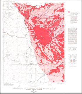
Formations that contain clays having swelling pressures higher than 2,500 pounds per square foot (as measured by the Potential Volume Change meter) are listed in order of decreasing swelling pressure: Denver Formation, Pierre Shale, Laramie Formation, Green Mountain Conglomerate, Fox Hills Sandstone, and Arapahoe Formation. Some landslides derived from these formations also contain swelling clay and are mapped with the bedrock formations listed above. |
First posted March 2, 2009 Part or all of this report is presented in Portable Document Format (PDF); the latest version of Adobe Reader or similar software is required to view it. Download the latest version of Adobe Reader, free of charge. |
Scott, G.R., 1972, Map showing areas containing swelling clay in the Morrison Quadrangle, Jefferson County, Colorado: U.S. Geological Survey Geologic Investigations Map I-790-C, scale 1:24,000.

![]() U.S. Department of the Interior |
U.S. Geological Survey
U.S. Department of the Interior |
U.S. Geological Survey
URL: http://pubsdata.usgs.gov/pubs/imap/790/c/index.html
Page Contact Information: GS Pubs Web Contact
Page Last Modified: Wednesday, 30-Nov-2016 17:39:26 EST
