Miscellaneous Investigations Series I-1420 (NL-14)
|
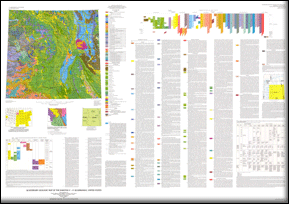
This map is part of the Quaternary Geologic Atlas of the United States (I-1420). It was first published as a printed edition in 1995. The geologic data has now been captured digitally and are presented here along with images of the printed map sheet and component parts as PDF files. The Quaternary Geologic Map of the Dakotas 4° x 6° Quadrangle was mapped as part of the Quaternary Geologic Atlas of the United States. The atlas was begun as an effort to depict the areal distribution of surficial geologic deposits and other materials that accumulated or formed during the past 2+ million years, the period that includes all activities of the human species. These materials are at the surface of the earth. They make up the "ground" on which we walk, the "dirt" in which we dig foundations, and the "soil" in which we grow crops. Most of our human activity is related in one way or another to these surface materials that are referred to collectively by many geologists as regolith, the mantle of fragmental and generally unconsolidated material that overlies the bedrock foundation of the continent. The maps were compiled at 1:1,000,000 scale. |
First posted March 4, 2011 For additional information contact: Part or all of this report is presented in Portable Document Format (PDF); the latest version of Adobe Reader or similar software is required to view it. Download the latest version of Adobe Reader, free of charge. |
Fullerton, D.S., Bluemle, L.C., Steece, F.V., Tipton, M.J., Bretz, Richard, and Goebel, J.E., 1995, Quaternary geologic map of the Dakotas 4° x 6° quadrangle, United States: U.S. Geological Survey Miscellaneous Investigations Series Map I–1420 (NL–14), scale 1:1,000,000.

![]() U.S. Department of the Interior |
U.S. Geological Survey
U.S. Department of the Interior |
U.S. Geological Survey
URL: http://pubsdata.usgs.gov/pubs/imap/i-1420/nl-14/index.html
Page Contact Information: GS Pubs Web Contact
Page Last Modified: Wednesday, 30-Nov-2016 17:35:12 EST