

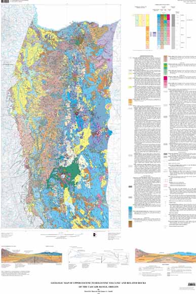
Since 1979, Earth scientists of the Geothermal Research Program of the U.S. Geological Survey have carried out multidisciplinary research in the Cascade Range. The goal of this research is to understand the geology, tectonics, and hydrology of the Cascades in order to characterize and quantify geothermal resource potential. A major goal of the program is compilation of a comprehensive geologic map of the entire Cascade Range that incorporates modern field studies and that has a unified and internally consistent explanation.
This map is one of three in a series that shows Cascade Range geology by fitting published and unpublished mapping into a province-wide scheme of rock units distinguished by composition and age; map sheets of the Cascade Range in Washington (Smith, 1993) and California will complete the series. The complete series forms a guide to exploration and evaluation of the geothermal resources of the Cascade Range and will be useful for studies of volcano hazards, volcanology, and tectonics.
| File
Name |
File
Type and Description |
File
Size |
| | ||
| FILES
for VIEWING and PLOTTING |
||
| PDF file of the 17-page descriptive geologic pamphlet that accompanies the map | 1.3 MB |
|
| PDF file of map sheet 1 that can be used for viewing map in a browser, as well as for plotting (geologic map, description of map units, correlation of map units, cross sections and text) | 12 MB |
|
| PDF file of map sheet 2 that can be used for viewing map in a browser, as well as for plotting (sources of data and references) | 239 KB |
|
Database for the Geologic Map of Upper Eocene to Holocene Volcanic and Related Rocks of the Cascade Range, Oregon, by Kathryn Nimz, David W. Ramsey, David R. Sherrod, and James G. Smith, USGS Data Series 313
Suggested citation and version history
For questions about the content of this report, contact Dave Sherrod.
Download a free copy of the current version of Adobe Reader.
| Help
| PDF help
| Western reports main page |
| Western Geologic and Miscellaneous Investigation Series Maps |
| Privacy
Statement | Disclaimer
| Accessibility |
| Geologic
Division | Volcano Hazards Program
|
This report is available in print form from:
USGS Information Services, Box 25286,
Federal Center, Denver, CO 80225
telephone: 888-ASK-USGS; e-mail: infoservices@usgs.gov