Geology, Minerals, Energy, & Geophysics Science Center
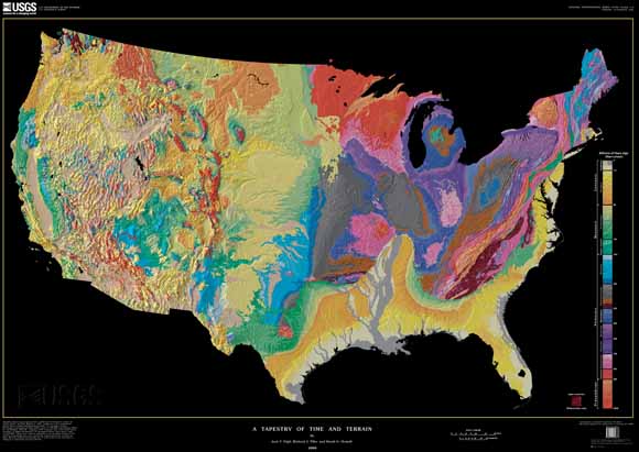
Through computer processing and enhancement, we have brought together two existing images of the lower 48 states of the United States (U.S.) into a single digital tapestry. Woven into the fabric of this new map are data from previous U.S. Geological Survey (USGS) maps that depict the topography and geology of the United States in separate formats. The resulting composite is the most detailed and accurate portrait of the U.S. land surface and the ages of its underlying rock formations yet displayed in the same image. The new map resembles traditional 3-D perspective drawings of landscapes with the addition of a fourth dimension, geologic time, which is shown in color. This union of topographic texture with the patterns defined by units of geologic time creates a visual synthesis that has escaped most prior attempts to combine shaded relief with a second characteristic shown by color, commonly height above sea level (already implicit in the shaded relief). In mutually enhancing the landscape and its underlying temporal structure, this digital tapestry outlines the geologic story of continental collision and break-up, mountain-building, river erosion and deposition, ice-cap glaciation, volcanism, and other events and processes that have shaped the region over the last 2.6 billion years
One of this map's two components is a digital shaded-relief image that shows the shape of the land surface by variations in brightness. The degree of light and dark artificially mimics the intensity of the Sun's light on different types of topography.
The second component of this tapestry, color, represents geologic time and is simplified from the geologic map of King and Beikman. Rocks contain information essential to an intelligent understanding of the Earth and its long natural history. Geologists determine the location, geographic extent, age, and physical and chemical characteristics of rocks and unconsolidated (loose) materials
Download the tapestry map as an ~56" x 40" PDF file (i2720_map.pdf; 46.5 MB)
Download the accompanying pamphlet as an 18-page PDF file (i2720_pamphlet.pdf; 2.6 MB)
(If you would like a version of the map that has a white background, oceans, and lakes with black lettering (uses less ink), download here.)
(If you would like a version of the map in native Photoshop format, download here.)
USGS Miscellaneous Investigations Series Map I-2206, Landforms of the Conterminous United States—A Digital Shaded-Relief Portrayal by Gail P. Thelin and Richard J. Pike. This is the full dataset for the topography layer for the tapestry map.
USGS Digital Data Series 11, Release 2, Geology of the Conterminous United States at 1:2,500,000 Scale—A Digital Representation of the 1974 P.B. King and H.M. Beikman Map by Paul G. Schruben, Raymond E. Arndt, and Walter J. Bawiec
USGS Professional Paper 901, Explanatory Text to Accompany the Geologic Map of the United States by Philip B. King and Helen M. Beikman
USGS Geologic Investigations Series 2781, The North America Tapestry of Time and Terrain by Kate E. Barton, David G. Howell, José F. Vigil (1:8,000,000 scale). This map was prepared in collaboration with the Geological Survey of Canada and the Mexican Consejo Recursos de Minerales.
USGS 0pen-File Report 00-443, Autobiography of Philip B. King by Philip Burke King. This manuscript was published over a dozen years after King's death by Mary Jane Coombs and Mike Diggles from pages Phil typed on his old manual Underwood typewriter.
For questions about the content of this report, contact Geology, Minerals, Energy, & Geophysics Science Center
Suggested citation and version history
Download a free copy of the latest version of Adobe Reader.
|
Help |
PDF help |
Publications main page |
| Western Geologic Investigations Series maps |
| Geology Research and Information |
Geology, Minerals, Energy, & Geophysics Science Center
|
This map and the accompanying pamphlet are also available in print form from:
USGS Information
Services, Box 25286,
Federal Center, Denver, CO 80225
telephone: 888-ASK-USGS; e-mail: infoservices@usgs.gov

![]() U.S. Department of the Interior | U.S. Geological Survey
U.S. Department of the Interior | U.S. Geological Survey
URL: https://pubs.usgs.gov/imap/i2720/
Page Contact Information: Michael Diggles
Page Created: May 31, 2000
Page Last Modified: July 18, 2013
(mfd)