U.S. Geological Survey Geologic Investigations Series I–2721
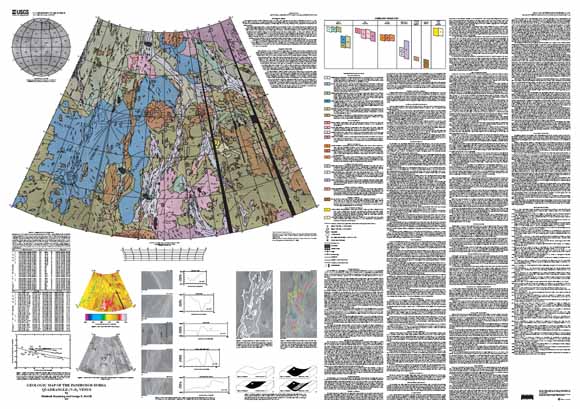
The Pandrosos Dorsa quadrangle (V–5), Venus, lies between latitudes 50° N. and 75° N. and longitudes 180° E. and 240° E. and includes the northern part of Vinmara Planitia. The quadrangle encompasses approximately 10 million square kilometers of the northern low-lying plains of the venusian surface and sits at an average radius of 6051.30 kilometers, approximately 500 meters below the mean planetary radius of 6051.84 kilometers.
Vinmara Planitia is dominated by a highly complex pattern of long, narrow, apparently deformed belts and their surrounding regional plains. These belts are defined as large-scale linear zones that contain and confine smaller scale ridges and radar-bright linear features; they are termed “linear belts” in this report. Vinmara Planitia contains one of the two highest concentrations of linear belts on Venus; the second being within Lavinia Planitia in the southern hemisphere. Unlike the belts of Lavinia Planitia, the linear belts of Vinmara Planitia contain a wide variety of morphologic styles, and the material within these belts spans a significant age range. Furthermore, the belts within Vinmara Planitia cover a surface area three times greater than the belts in Lavinia Planitia.
All or parts of twelve linear belts are within the Pandrosos Dorsa quadrangle: Lukelong, Lauma, Okipeta, Iris, Surupa, Ahsonnuti, Akuanda, Tikoiwati, Aida-Wedo, Anpao (the linear belt in the longitudinal center of the quadrangle), an unnamed belt, and Pandrosos, the linear belt for which the quadrangle is named. Other small concentrations of ridges are present but are not substantial enough to be cataloged as major linear belts. Topographically, the belts commonly reach heights of approximately one kilometer above the surrounding plains, although portions of the belts are not elevated or even occur within troughs. Together, the twelve linear belts create a fanlike geometric pattern in plan view and form the majority of what has been referred to as the “Ridge Belt Plains-Fan Assemblage” (Frank and Head, 1990). As this name implies, some of the features within the belts are ridges. However, nearly half of the features within the belt boundaries are either recognizable grabens or radar-bright linear features, which are generally interpreted as extensional fractures. Therefore, the more general term “linear belt” is preferable to ridge belt. The linear belts of the Pandrosos Dorsa quadrangle continue northward to the pole and southward into the regions of Nemesis Tessera (V–14) and Bellona Fossae (V–15) where they lose their intensity and eventually die out (Zimbelman, 1995).
In addition to the linear belts, the quadrangle includes the easternmost part of the regional plains of Atalanta Planitia and the northern part of Vinmara Planitia. These widespread plains lie approximately 500 meters below the mean planetary radius and show little to no topography. Atalanta and Vinmara Planitiae are similar to other regional plains covering nearly 80 percent of the global surface (Masursky and others, 1980), except that the plains of Vinmara contain far fewer wrinkle ridges.
The quadrangle also includes two large and elongate patches of tessera: Virilis on the east edge of the quadrangle and Bathkol farther west. These blocks of tessera materials mimic the nearly north-south orientation of the linear belts at elevations approximately one kilometer above the surrounding regional plains. Other major features within the quadrangle include twelve impact craters, two of which are large and include outflow material; nine coronae and coronalike features; seven volcanic shield fields; numerous small tessera inliers; and part of one lava channel.
This region is of geologic interest because it contains the most widespread and largest concentration of extensive linear belts on Venus, and thus it is an ideal area to study the temporal and genetic relations between linear belts and regional plains. The variety of morphologies, structural styles, and temporal relations within the Pandrosos Dorsa quadrangle provides a unique opportunity for establishing stratigraphic relations not only among material units but also among tectonic episodes. Because the preserved record of tectonic processes on Venus is different from that of the oceanic plate tectonics we recognize on Earth (Solomon and others, 1991, 1992), the Pandrosos Dorsa quadrangle is a key region of study for illuminating past and present tectonic styles of Venus. Interpretations extracted from this study may apply to other venusian linear belts and may help explain crustal and upper mantle properties and processes.
Last modified March 21, 2012
First posted January 28, 2004
For additional information:
Contact Astrogeology Research Program staff
Astrogeology Science Center
U.S. Geological Survey
2255 N. Gemini Dr.
Flagstaff, AZ 86001
http://astrogeology.usgs.gov/
This report is presented in Portable Document Format (PDF); the latest version of Adobe Reader or similar software is required to view it. Download the latest version of Adobe Reader, free of charge.
Rosenberg E., and McGill, G.E., 2001, Geologic map of the Pandrosos Dorsa quadrangle (V–5), Venus: U.S. Geological Survey Geologic Investigations Series I–2721, available at https://pubs.usgs.gov/imap/i2721/.

![]() U.S. Department of the Interior |
U.S. Geological Survey
U.S. Department of the Interior |
U.S. Geological Survey
URL: http://pubsdata.usgs.gov/pubs/imap/i2721/index.html
Page Contact Information: GS Pubs Web Contact
Page Last Modified: Wednesday, 30-Nov-2016 17:36:21 EST
