
U.S.
Geological Survey
Geologic Investigation Series I-2767
Published 2002
Geology of the Stegall
Mountain 7.5-minute Quadrangle, Shannon and Carter Counties, South-Central Missouri
By R.W. Harrison, R.C. Orndorff, and
D.J. Weary
Online Version 1.0
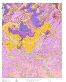
Above: Thumbnail image of the geologic map of the Stegall Mountain Quadrangle
(Detailed graphics files available for download
below).
|
|
|
|
|
 |
|
|
|
Abstract
The bedrock exposed in the Stegall Mountain
Quadrangle, Missouri, comprises Mesoproterozoic aged volcanic
rocks overlain by Late Cambrian and Early Ordovician aged dolomite,
sandstone, and chert. The sedimentary rocks are nearly flat-lying
except where they drape around knobs of the volcanic rocks
or where they are adjacent to faults. The carbonates are karstified
and the area contains numerous sinkholes, springs, caves, and
losing-streams.
This map is one of several being produced under the
U.S. Geological Survey National Cooperative Geologic Mapping Program to
provide geologic data applicable to land-use problems in the Ozarks of
south-central Missouri. Ongoing and potential industrial and
agricultural development in the Ozarks region has presented issues of
ground-water quality in karst areas. A National Park in this
region (Ozark National Scenic Riverways, Missouri ) is concerned about
the effects of activities in areas outside of their stewardship on the
water resources that define the heart of this Park. This task applies
geologic mapping and karst investigations to address issues surrounding
competing land use in south-central Missouri. This task keeps
geologists from the USGS associated with the park and allows the Parks
to utilize USGS expertise and aid the NPS on how to effectively use
geologic maps for Park management. For more information see: http://geology.er.usgs.gov/eespteam/Karst/
|
|
Data Available in this Report
- Download compressed GIS
vector and raster data: (GISdata.zip,
5.97 MB)
- Metadata available in compressed .html
files: (metadata.zip 40 KB)
U.S. Department of the Interior, U.S. Geological Survey
URL: https://pubsdata.usgs.gov/pubs/imap/i2767/index.htm
Direct questions and comments to: David J. Weary
U.S. Geological Survey
Email dweary@usgs.gov
Maintained by Eastern Publications Group
Last modified: 17:38:13 Wed 30 Nov 2016
Privacy statement | General disclaimer | Accessibility