U.S. Geological Survey Miscellaneous Field Studies Map MF-709
Introduction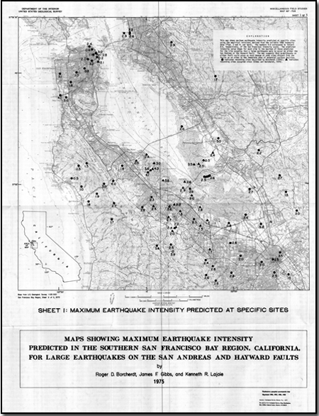
The amount of damage resulting from the great California earthquake of April 18, 1906, varied significantly for different parts of the San Francisco Bay region. In some areas the damage was weak with "occasiona1 fall of chimneys and damage to plaster, partitions, plumbing and the like," in other nearby areas the damage was violent with "... fairly general collapse of brick and frame structures when not unusually strong..." (Wood, 1908). These large variations were due partly to distance from the zone of surface faulting and partly to the geologic character of the ground (compare the intensity map for San Francisco (fig. 1) with the geologic map (fig. 2)). In this paper, empirical relations are derived that quantify the dependencies of the 1906 intensities on distance and the geologic character of the ground. These relations are used to predict maximum intensities for possible future earthquakes at a scale of 1:125,000 for the San Francisco Bay region. The San Francisco Bay region is likely to experience large earthquakes in the future. Economical reduction of the hazards associated with potential earthquakes requires delineation of areas that are especially susceptible to damage. Maps that show predicted earthquake intensity on a regional scale provide such delineations and they provide qualitative estimates of the potential hazard at specific sites. Predictions of earthquake intensity for the San Francisco Bay region are especially needed for a large earthquake on the Hayward fault. In addition, predictions of intensity for areas not developed at the time of the 1906 earthquake are needed for a large earthquake on the San Andreas fault. |
First posted August 10, 2009
For additional information: This report is presented in Portable Document Format (PDF); the latest version of Adobe Reader or similar software is required to view it. Download the latest version of Adobe Reader, free of charge. |
Borcherdt, Roger D., Gibbs, James F., and Lajoie, Kenneth R., 1977, Prediction of maximum earthquake intensity in the San Francisco Bay region, California, for large earthquakes on the San Andreas and Hayward Faults: U.S. Geological Survey Miscellaneous Field Studies Map MF-709, 3 sheets, scale 1:250,000, 11 p.
Introduction
Intensity vs. Distance
Prediction of Maximum Earthquake Intensity at Specific Sites
Intensity Increments vs. Local Geologic Units
Prediction of Maximum Earthquake Intensity on a Regional Scale
Summary
References Cited
Geology
3 plates

![]() U.S. Department of the Interior |
U.S. Geological Survey
U.S. Department of the Interior |
U.S. Geological Survey
URL: http://
pubsdata.usgs.gov
/pubs/mf/1977/0709/index.html
Page Contact Information: USGS Publications Team
Page Last Modified: Thursday, 01-Dec-2016 12:10:24 EST
