U.S. Geological Survey Miscellaneous Field Studies MF–2373
This report depicts the geologic framework and structure of both the upland and adjacent lowland areas in the vicinity of southwestern Santa Clara ("Silicon") Valley and the southern Santa Cruz Mountains. The maps encompass parts of Santa Clara and Santa Cruz Counties and include new and revised geologic mapping of the Los Gatos, Santa Teresa Hills, Laurel, Loma Prieta, and Mount Madonna 7.5' quadrangles and parts of the Morgan Hill and Gilroy 7.5' quadrangles. The mapping was carried out under the National Cooperative Geologic Mapping and Earthquake Hazards Reduction Programs of the U.S. Geological Survey between 1988 and 1997. The mapping was undertaken as part of projects to map the geology of the 1:100,000 San Jose quadrangle and to investigate the geology of the epicentral region of the October 17, 1989 Loma Prieta Earthquake. Some mapping is compiled from older sources. The seven maps are the first detailed depiction of the bedrock stratigraphy and structure along both sides of the San Andreas fault in the southern San Francisco Bay Area.
The description of rock units and structure are arranged by major fault blocks of different basement composition that are separated by the San Andreas fault. The Salinian terrane, which lies southwest of the San Andreas fault, is a regionally extensive Mesozoic rock assemblage, largely of continental affinity, composed of granitic to gabbroic rocks with roof pendants of high temperature metasedimentary rocks. Northeast of the San Andreas fault, the basement is a composite of the Franciscan Complex, the Coast Range ophiolite, and parts of the Great Valley Sequence, a disrupted assemblage of rocks which originally formed the Mesozoic convergent continental margin. The Santa Cruz fault block of this report is comprised entirely of rocks of the Salinian terrane. The Santa Cruz block, in turn, is divided into the subsidiary Ben Lomond and La Honda fault blocks by the Zayante fault. Northeast of the San Andreas fault the Mesozoic composite basement is broken into the subsidiary Sierra Azul and New Almaden blocks along a complex fault boundary consisting of locally merged segments of the Sargent, Berrocal, Sierra Azul, and Aldercroft faults. This complex block boundary is further considered to represent a part of the regionally extensive Coast Range fault, which everywhere separates Mesozoic forearc strata of the Great Valley Sequence from the Franciscan Complex.
The Coast Range fault has been interpreted as a major attenuation fault associated with Late Cretaceous to early Tertiary unroofing of the Franciscan Complex. An alternative model interprets the Coast Range fault as the roof thrust of a thick, regionally extensive system of tectonic wedges. Rocks between the San Andreas fault zone and the Sargent-Berrocal-Sierra Azul-Aldercroft fault zone are a part of the Sierra Azul block. Rocks in the Santa Teresa Hills that have a stratigraphy similar to that of the Sierra Azul area are considered a thrust klippe of the Sierra Azul block.
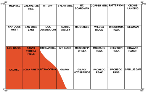
Index map of 7.5' quadrangles in the 1:100,000 San Jose quadrangle. The area covered by this report is shown in red tint.
scvmfdb.txt - Text-only version of a file that describes the digital content of this publication and explains how to use the digital database (47 kB).
scvmfdb.pdf - PDF version of a file that describes the digital content of this publication and explains how to use the digital database (138 kB).
mf2373.met.txt - Text-only file of the FGDC-compliant metadata for this publication (313 kB).
mf2373.rev.txt - Text-only file containing the revision list for this publication (2 kB).
mf2373db.tgz Compressed (using gzip) tar file of the digital database (comprised of Arc/Info and supporting database files) for the three maps that make up this publication (17.9 MB).
Sheet 1 of 8: lgmap.pdf - PDF file of the Los Gatos quadrangle at a scale of 1:24,000 (3.6 MB).
Sheet 2 of 8: lrmap.pdf PDF file of the Laurel quadrangle at a scale of 1:24,000 (2.4 MB).
Sheet 3 of 8: lpmap.pdf - PDF file of the Loma Prieta quadrangle at a scale of 1:24,000 (3.4 MB).
Sheet 4 of 8: sth-mhmap.pdf - PDF file of the Santa Teresa Hills and southwestern part of the Morgan Hill quadrangles at a scale of 1:24,000 (3.3 MB).
Sheet 5 of 8: mm-glmap.pdf - PDF file of the Mt. Madonna and southwestern part of the Gilroy quadrangles at a scale of 1:24,000 (2.8 MB).
Sheet 6 of 8: scvexpl.pdf - PDF file of map keys, index maps, and map units for the southwestern Santa Clara Valley and southern Santa Cruz Mountains, Santa Clara, and Santa Cruz Counties, California (4.9 MB).
Sheet 7 of 8: scvxsec1.pdf - PDF file of five cross sections for the Los Gatos and Santa Teresa Hills quadrangles (471 kB).
Sheet 8 of 8: scvxsec2.pdf - PDF file of four cross sections for the Laurel and Loma Prieta quadrangles (454 kB).
Pamphlet: scvmf.pdf - PDF file of page-sized pamphlet containing detailed unit descriptions and geologic information, plus sources of data, and references (82 kB).
mf2373pdf.tgz - Compressed (using gzip) tar file containing PDF files of the map sheets and pamphlets for this publication (19 MB).
mf2373ps.tgz - Compressed (using gzip) tar file containing PostScript files of the map sheets and pamphlets for this publication (21 MB).
For additional information:
Contact Information, Western Region Geology and Geophysics Science Center—Menlo Park
U.S. Geological Survey
345 Middlefield Road, MS-973
Menlo Park, CA 94025-3591
http://geomaps.wr.usgs.gov/
McLaughlin, R.J., Clark, J.C., Brabb, E.E., Helley, E.J., and Colóns, C.J., 2002, Geologic maps and structure sections of the southwestern Santa Clara Valley and southern Santa Cruz Mountains, Santa Clara and Santa Cruz Counties, California: U.S. Geological Survey Miscellaneous Field Studies MF–2373, 8 sheets scale 1:24,000, pamphlet 13 p., and GIS data. (Available at https://pubs.usgs.gov/mf/2002/2373/.)
Part of this report is presented in Portable Document Format (PDF); the latest version of Adobe Reader or similar software is required to view it. Download the latest version of Adobe Reader, free of charge.
Last modified Friday, June 29, 2012
First posted February 6, 2002

![]() U.S. Department of the Interior |
U.S. Geological Survey
U.S. Department of the Interior |
U.S. Geological Survey
URL: http://pubsdata.usgs.gov/pubs/mf/2002/2373/index.html
Page Contact Information: GS Pubs Web Contact
Page Last Modified: Thursday, 01-Dec-2016 12:08:50 EST
