
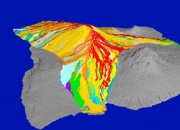
 This computer-generated image of the Island of Hawai‘i shows the lava flows emanating from Mauna Loa that have been recorded since 1832. View is towards the west with the city of Hilo at bottom center, the southwest tip of the island at upper left, and the Kona coast at the top.
The Island of Hawai‘i is composed of five coalesced basaltic volcanoes. Lava flows constitute the greatest volcanic hazard from these volcanoes. This report is concerned with lava flow hazards on Mauna Loa, the largest of the island shield volcanoes. Hilo lies 58 km from the summit of Mauna Loa, the Kona coast 33 km, and the southernmost point of the island 61 km.
Hawaiian volcanoes erupt two morphologically distinct types of lava, aa and pahoehoe. The surfaces of pahoehoe flows are rather smooth and undulating. Pahoehoe flows are commonly fed by lava tubes, which are well insulated, lava-filled conduits contained within the flows. The surfaces of aa flows are extremely rough and composed of lava fragments. Aa flows usually form lava channels rather than lava tubes.
In Hawai‘i, lava flows are known to reach distances of 50 km or more. The flows usually advance slowly enough that people can escape from their paths. Anything overwhelmed by a flow will be damaged or destroyed by burial, crushing, or ignition. Mauna Loa makes up 51 percent of the surface area of the Island of Hawai‘i. Geologic mapping shows that lava flows have covered more than 40 percent of the surface every 1,000 years. Since written descriptions of its activity began in A.D. 1832, Mauna Loa has erupted 33 times. Some eruptions begin with only brief seismic unrest, whereas others start several months to a year following increased seismic activity. Once underway, the eruptions can produce lava flows that reach the sea in less than 24 hours, severing roads and utilities. For example, the 1950 flows from the southwest rift zone reached the ocean in approximately three hours. The two longest flows of Mauna Loa are pahoehoe flows from the 50-kilometer-long 1859 and the 48-kilometer-long 1880-81 eruptions.
Mauna Loa will undoubtedly erupt again. When it does, the first critical question that must be answered is: Which areas are threatened with inundation? Once the threatened areas are established, we can address the second critical question: What people, property, and facilities are at risk? These questions can be answered by estimating the areas most likely to be affected by eruptions originating on various parts of the volcano. This report contains such estimates, based on the known source vents and areas affected by past eruptions. We have divided the volcano into potential lava inundation zones and prepared maps of these zones, which are presented here on the accompanying map sheets.
Files available for downloading include 10 map sheets and one pamphlet.
|
Description of file
|
Page-size PDF
|
Full-size PDF
|
EPS (Encapsulated PostScript) file or other type
|
| Sheet 1. Index showing inundation zones on the flanks of Mauna Loa | |||
| Sheet 2. Kaumana, Waiakea, and Volcano-Mountain View | |||
| Sheet 3. Kapapala | Sheet 4. Pahala, Punalu'u, and Wood Valley | ||
| Sheet 5. Na'alehu | |||
| Sheet 6. Ka Lae | |||
| Sheet 7. HOVE, Kapu'a, and Miloli'i | |||
| Sheet 8. Ho'okena, Kaÿohe, and Ka'apuna | |||
| Sheet 9. Honaunau and Kealakekua | |||
| Sheet 10. Puako | |||
| 14-page pamphlet |
For questions about the scientific content of this report, contact Frank Trusdell
Download a free copy of Adobe Reader
This report is available via print on demand.
| Help
| PDF help |
| Publications main page
| Miscellaneous Field Studies Maps |
| Department of the Interior
| U.S. Geological Survey |
| Geologic Division
| Volcano Hazards Program |
| Privacy Statement
| Disclaimer
| Accessibility |
URL of this page is:
https://pubs.usgs.gov/mf/2002/2401/
Please send comments and suggestions, or report problems, to:
Michael Diggles
Updated: May 3, 2007 (bwr, mfd)