Geologic Features of the Sea Bottom Around a
Municipal Sludge Dumpsite near 39ĝN, 73ĝW, Offshore New Jersey
and New York: U.S. Geological Survey Open-file Report 94-152
An area of the sea floor south of Hudson Canyon off New Jersey
was mapped as part of a study to determine the effects of offshore
dumping of municipal sewage sludge on the sea bottom. The dump site
for municipal sludge lies within a large area of continental slope and
continental rise that has been used for offshore dumping since the
1950's. The area is called Deep Water Dumpsite 106, because the
original site lay approximately 106 miles offshore.
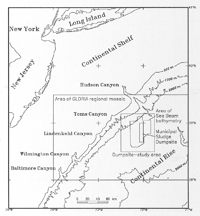
An Index Map showing the continental margin off the mid-Atlantic
Coast of the U.S. Areas of the following GLORIA mosaic illustration
and the site-mapping studies are outlined as rectangles; an area
mapped using Sea Beam bathymetry is shown as an irregular polygon; and
the most recent sludge dumpsite area is outlined as a smaller
north-south rectangle.
Previous stratigraphic investigations of this offshore region using data from
boreholes and seismic profiles show that sequences of continental rise
sediments lap onto eroded, slightly seaward-dipping strata of the lower
continental slope.

Airgun seismic-reflection profile across the central part of the
study area. Nearly flat continental-rise sediments of Neogene age lap
onto an unconformity on seaward-dipping Eocene strata of the
continental slope.
Brecciated rocks and exotic sediments that are found in borehole samples,
and faults and chaotic and distorted seismic facies that are revealed
in profiles show that submarine landsliding has been the principal
agent of deposition on the upper rise during the Cenozoic
(Poag and Mountain, 1987).
Previous environmental geologic studies of the dumpsite area include
those of Neiheisel (1979, 1983),
who investigated geochemical and physical parameters of surface sediment
samples. Hanselman and Ryan
(1983), and Rawson and Ryan (1983)
reported bottom observations from the deep sea research vessel (DSRV)
Alvin. Ryan and Farre (1983)
discussed geologic processes in the dumpsite area and inferred that
both mass wasting and turbidity currents have been active and may
presently be active within this area.
Pratson and Laine (1989), mapped the
surficial character of the sea bottom using 3.5-kHz echo-sounding
profiles.
To study the geologic context and processes of this submarine dumpsite
and to provide information for choosing appropriate sample sites where
fine-grained material might be more likely to accumulate, the sea-floor
of the dumpsite area was mapped using multibeam bathymetry,
sidescan-sonar images, subbottom profiles, bottom photographs and
video, and bottom-sediment samples.
Fred Grassle of Rutgers University organized the program to study the
benthic environment of the deep-water dumpsite region near 39ĝN,
73ĝW,
of which this investigation is one part. I thank the officers and
crews of RV Atlantis II, Rv Oceanus, and RV Betty Chouest, the Alvin
group and the Deep Submergence Laboratory of the Woods Hole
Oceanographic Institution, and the Sea Beam processing group of the
Graduate School of Oceanography, University of Rhode Island; Joyce
Miller shepherded the collection and processing of the Sea Beam
bathymetric data aboard Atlantis II. This research was funded by the
National Undersea Research Program (NURP) of the National Oceanic and
Atmospheric Administration (NOAA) and the U.S. Geological Survey (USGS).
- To continue, click on:
- Data and Methods...
- Description of the sea floor...
- Discussion...
- Conclusions...
- References Cited...
- Illustrations Summary
- Or, to review, click on:
- Abstract...
- Introduction...
******
[an error occurred while processing this directive]