The magnetostratigraphies of the Black Rock and Pit of Death cores suggest that they cover essentially the same time range, although their depositional rates differed considerably through time. The Pit of Death sediments appear to have accumulated at a relatively constant rate (Fig. 11), whereas the Black Rock sediments accumulated at a more rapid rate than at Pit of Death throughout the core, but underwent a major decline in deposition above the Olduvai Subchron. Sediment accumulation rates in the Black Rock core above the Olduvai subchron are much slower than those below this horizon in this core.
The general impression is that the Pit of Death core, which spans essentially the same time interval as the Black Rock core, contains sediments that indicate drier conditions or lower lake levels than the Black Rock core, although both sites underwent virtually continuous deposition. The Black Rock site is in a valley through which the modern Beaver River flows. Machette (1985) showed that the Beaver River did not exit the Beaver basin, southeast of the Black Rock site, as a through-flowing stream until after about 0.75 Ma, possibly in response to climate change that produced greater runoff from the mountains. Even without the Beaver River in its modern form, it is likely that some ancestral version of the Beaver River emptied into the Sevier Desert near Black Rock during Pliocene and Pleistocene time. It is unlikely that a major river discharged sediment directly to the Pit of Death site at any time, although both the Sevier and Beaver Rivers probably supplied fine-grained sediment to the basin margins that would have been redistributed to distal sites such as this. Muddy lake beds similar to those in the Sevier Desert were being deposited along the Sevier River drainage system in Mills Valley, east of the Canyon Range (Figure 1), between at least 2 and 0.65 Ma (Oviatt, 1992), and in the Beaver basin between about 2.5 and 0.75 Ma (Machette, 1985), suggesting that the shallow-lake/wet-mudflat/marsh environment represented in the Pit of Death and Black Rock cores was widespread and long-lived in this region. The Black Rock pollen record indicates that significant variations in moisture occurred during the period from 3.1 to 1.6 Ma, although the paleontological and paleohydrological data collectively indicate that conditions remained wetter than those of today throughout this interval, as they did at other sites across the western United States (Thompson, 1991).
 View figure 14 or
download the postscript file.
View figure 14 or
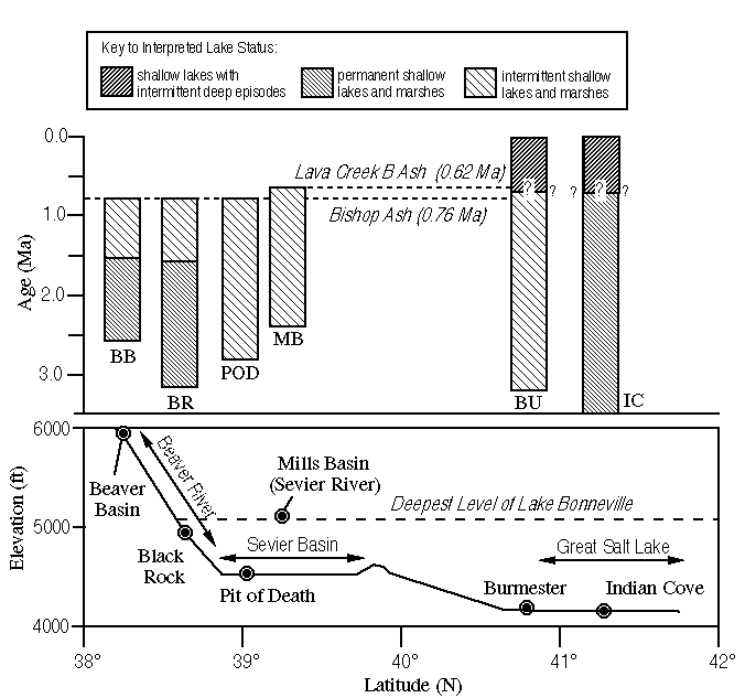
download the postscript file.Comparison of lacustrine histories of Pliocene-Pleistocene sites in western Utah.
The Black Rock and Pit of Death records can be integrated with other data from western Utah to provide a synoptic view of changing hydrological and climatic conditions since the middle Pliocene (Fig. 14). The Beaver Basin (Machette, 1985) and Black Rock sites both had relatively rapid and apparently constant depositional rates from Gauss (Black Rock) or early Matuyama time (Beaver Basin) until ~1.7 to ~1.6 Ma. Depositional rates are much slower after this time, although waters were at least episodically present at both sites until ~0.76 to 0.75 Ma. Shallow intermittent lakes were also present at the Pit of Death and Mills Basin (Oviatt, 1992) sites through the same time span (and may have persisted somewhat longer in the Mills Basin). Farther north, preliminary examination of the Burmester core (Eardley et al., 1973; Williams, 1994) from near modern Great Salt Lake suggests that shallow intermittent lakes, wet playas, and marshes were probably present from prior to 3 Ma until above the Bishop Ash. Palynological data from well-cuttings of Pliocene and early Pleistocene sediments from Indian Cove in Great Salt Lake (Davis, 1993) indicate shallow marsh environments were present throughout this period.
Collectively the data discussed above indicate that slightly wetter-than-modern conditions persisted through much of the Pliocene and early Pleistocene in western Utah. The modernity of the Black Rock pollen flora suggests that the modern climate with winter-precipitation dominance and dry summers was established by this time. Although the Black Rock pollen record indicates that there was an oscillation between wetter and drier conditions during the Pliocene and early Pleistocene, these fluctuations were of much smaller amplitude than those of the late Quaternary. Scattered evidence suggests that the late Quaternary climatic pattern of high amplitude climatic fluctuations (where wet climate episodes with lakes as deep as Lake Bonneville [Fig. 14] were present for perhaps 10 kyr and were separated by perhaps 90 kyr or more) began prior to the deposition of the Lava Creek B tephra at 0.62 Ma.
Continue to Acknowledgments