U.S. Geological Survey Open-File Report 95-820
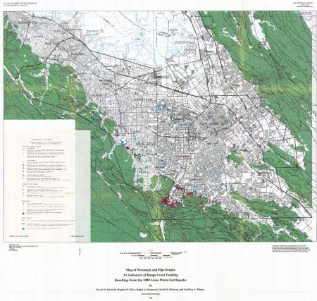
AbstractDamage to pavement and near-surface utility pipes, caused by the October 17, 1989, Loma Prieta earthquake, provide indicators for ground deformation in a 663 km2 area near the southwest margin of the Santa Clara Valley, California. The spatial distribution of 1284 sites of such damage documents the extent and distribution of detectable ground deformation. Damage was concentrated in four zones, three of which are near previously mapped faults. The zone through Los Gatos showed the highest concentration of damage, as well as evidence for pre- and post-earthquake deformation. Damage along the foot of the Santa Cruz Mountains reflected shortening that is consistent with movement along reverse faults in the region and with the hypothesis that tectonic strain is distributed widely across numerous faults in the California Coast Ranges. |
First posted July 8, 2009
This report is available only on the Web For additional information contact: This report is presented in Portable Document Format (PDF); at least version 7 of Adobe Reader or similar software is required to view it. Download the latest version of Adobe Reader, free of charge. |
Schmidt, Kevin M., Ellen, Stephen D., Haugerud, Ralph A., Peterson, David M., and Phelps, Geoffrey A., 1995, Breaks in pavement and pipes as indicators of range-front faulting resulting from the 1989 Loma Prieta Earthquake near the southwest margin of the Santa Clara Valley, California: U.S. Geological Survey Open-File Report 95-820, 33 p., 2 plates, scale 1:62,500 [https://pubs.usgs.gov/of/1995/of95-820/].
Abstract
Introduction
Acknowledgments
Damage, Methods, and Sources of Information
Limitations
Categories of Damage
Results
Analysis
Discussion
Conclusion
References Cited
two plates

![]() U.S. Department of the Interior |
U.S. Geological Survey
U.S. Department of the Interior |
U.S. Geological Survey
[an error occurred while processing this directive]
URL: https://pubsdata.usgs.gov
Page Contact Information: Contact USGS
Page Last Modified: Wednesday, December 07 2016, 04:00:35 PM (mfd)
