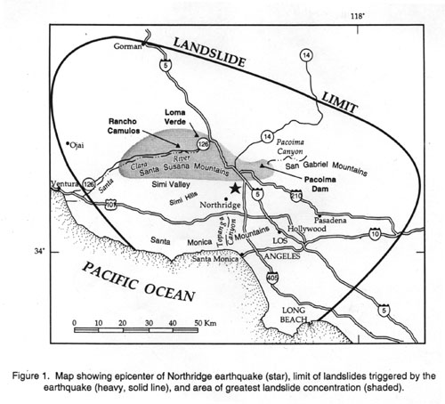
The Northridge earthquake triggered landslides over an area of about 10,000 km² that is roughly concentric about the epicenter (fig. 1). The landslide limit is the smoothed curve connecting the locations of farthest landslides at several different azimuths from the epicenter. The maximum epicentral distance to the landslide limit is about 70 km, which is about average in relation to historical worldwide earthquakes of this magnitude (Keefer, 1984). Within this broad area of scattered landslide activity is a 1,000-km² area of much more concentrated landsliding that lies north and northwest of the epicenter, primarily in the Santa Susana Mountains and the mountains north of the Santa Clara River valley (fig. 1). This area of greatest landslide concentration consists primarily of Late Miocene through Pleistocene clastic sediment having little or no cementation and that has been folded and uplifted by rapid tectonic deformation. The young, weak material lacks significant tensile strength and erodes readily to form steep-walled canyons that commonly head in nearly vertical slopes. The combination of low strength and steep relief reaching elevations of 1,000 m above sea level makes the area highly susceptible to failure during seismic shaking.
Landslides were densest along the steep-walled canyons that have been incised into the northern and southern flanks of the Santa Susana Mountains; slides were sparser along the gently domed crest of those mountains (plates 1 and 2). In the northeast part of the Santa Susana Mountains, landslide distribution reflects the regional geologic structure; outcropping strata that form steep ridges can be traced laterally by the broadly arcuate bands of landslides. Landslides were much more sparsely scattered throughout the Santa Monica and San Gabriel Mountains, which generally consist of more competent rock than exists in the Santa Susanas. One notable exception is the area in and around Pacoima Canyon, described subsequently.
The most common types of landslides triggered by the earthquake were highly disrupted, shallow falls and slides of rock and debris, numbering in the thousands to tens of thousands (if very small failures are considered) and extending over the entire area within the landslide limit. Deeper, more coherent slumps and block slides, commonly in more competent materials, numbered in the tens to perhaps hundreds and occurred primarily in the Santa Susana and Santa Monica Mountains. One well-developed liquefaction-induced lateral spread was mapped in Tapo Canyon (plate 2); other incipient lateral spreads have been reported but were not visible in the airphotos.
As described previously, the Santa Susana Mountains and the mountains north of the Santa Clara River valley are extremely susceptible to failure during seismic shaking. In some areas in the Santa Susana Mountains, more than 75 percent of the slope area was denuded by landslides triggered by strong shaking (fig. 2) . Characteristic landslides in this area were several decimeters to a few meters deep and consisted of dry, highly disaggregated material that cascaded downslope to flatter areas at or near the base of the steep slopes (fig. 3).
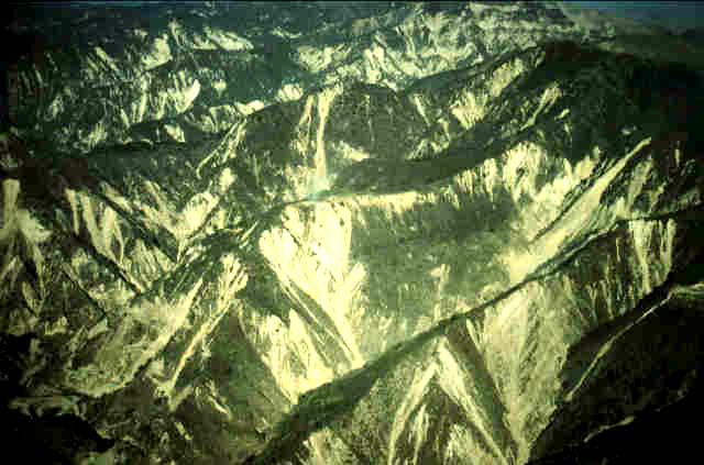 Figure 2.
Denudation of slopes in the Santa Susana Mountains.All of the light-colored areas are landslides that failed during
the Northridge earthquake;many of these existed before the earthquake and were reactivated.
Figure 2.
Denudation of slopes in the Santa Susana Mountains.All of the light-colored areas are landslides that failed during
the Northridge earthquake;many of these existed before the earthquake and were reactivated.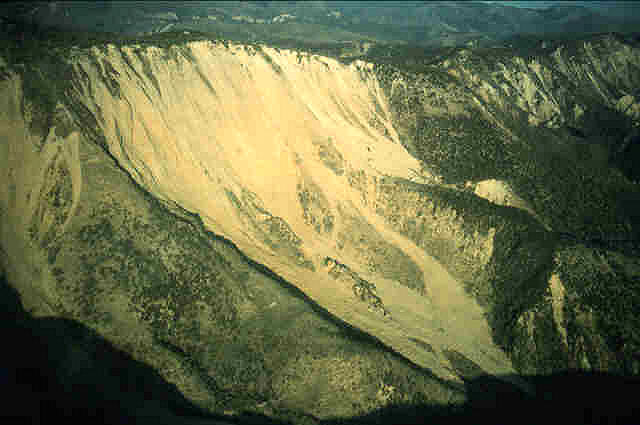 Figure 3.
Shallow,disrupted slide in very weakly cemented sediment in the Santa Susana Mountains.Slide is about 1 km wide
at its head.
Figure 3.
Shallow,disrupted slide in very weakly cemented sediment in the Santa Susana Mountains.Slide is about 1 km wide
at its head.These failures ranged in volume from a fraction of a cubic meter to a few hundred thousand cubic meters. Some of the larger slides traveled several hundred meters from their points of origin, and in some cases, landslide debris traveled 100-200 m onto flatter areas beyond the bases of steep parent slopes (fig. 4). Deposits of loose, disaggregated sediment from such slides are in some places several meters thick. Where these deposits fill ravines, they pose a continuing hazard from remobilization and flow during future intense, prolonged rainfall.
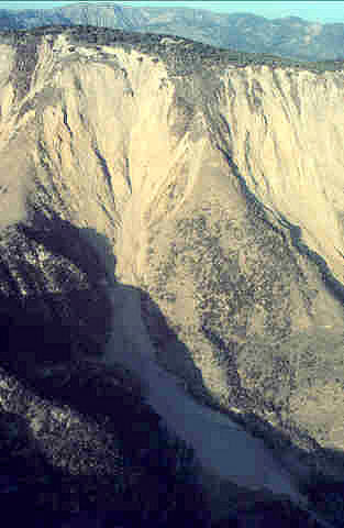 Figure 4.
Large disrupted slide in weakly cemented sediment in Tapo Canyon (plate 2) that has a runout distance of about
200 m from the break in slope at the base of the ridge.
Figure 4.
Large disrupted slide in weakly cemented sediment in Tapo Canyon (plate 2) that has a runout distance of about
200 m from the break in slope at the base of the ridge.Northeast of the epicenter, fewer and more widely scattered rock falls were triggered in the San Gabriel Mountains, which consist primarily of Mesozoic granitic and Precambrian metamorphic rock that, although deeply weathered, is more competent than the weak sediment of the Santa Susana Mountains. An exception is the southwest corner of the San Gabriel Mountains, where younger sediment produced abundant failures comparable to those in the Santa Susana Mountains. One area of exceptionally abundant landslide activity in the Mesozoic intrusive rock of the San Gabriel Mountains is near the mouth of Pacoima Canyon,where landslide concentrations were as high as in the Santa Susana Mountains (plates 1 and 2). Slopes in surrounding canyons, however, had relatively few rock falls and rock slides despite having similar rock types exposed. Our preliminary assessment of the characteristics of these rocks that determine their susceptibility to seismic failure (criteria from Harp and Noble, 1993) indicates no significant differences between the rock-mass quality in Pacoima Canyon and that of surrounding canyons that experienced far fewer slides. Pacoima Canyon does, however, have much steeper, higher slopes than surrounding canyons, and this may make the slopes there inherently less stable as well as contributing to locally amplified strong shaking. Certainly shaking levels were high at Pacoima Dam, where strong-motion records on bedrock at the south abutment produced peak accelerations of about 1.5 g (Shakal and others, 1994). Interestingly, the 1971 San Fernando earthquake also produced anomalously high ground accelerations in Pacoima Canyon (Cloud and Hudson, 1975).
The scattered landslides in the Santa Monica Mountains generally are fairly small, shallow, disrupted landslides. This presumably is because most of the rock in the Santa Monicas is more competent than that in the Santa Susanas and because the ground shaking appears to have been lower in the Santa Monicas. The highest concentration of slides is from the very high, steep slopes in Malibu Canyon (plate 1).
Although deep, coherent landslides triggered by the earthquake were far less numerous than disrupted slides, they contributed significantly to the total volume of landslide material because they tended to be much larger. Slumps and block slides having volumes of several hundreds to thousands of cubic meters occurred in some of the more competent sedimentary units in the Santa Susana Mountains and in the mountains north of the Santa Clara River. Several block slides also were triggered in the Tertiary sedimentary rocks of the central and eastern Santa Monica Mountains, south of the epicenter. A few deep-seated landslides triggered by the earthquake had volumes reaching several million cubic meters. Interestingly, most of these large, deep landslides occurred along the same ridge, north of the Santa Clara River valley between Piru and Castaic Junction (plate 2), where a clayey facies of the Pico Formation crops out along the entire length of the ridge. We briefly describe some of these landslides, and others of note, in the sections below.
San Martinez Grande Landslide. The largest landslide triggered by the Northridge earthquake was the San Martinez Grande landslide, located within thinly bedded clay shale of the Pico Formation on the south side of the ridge that lies south of San Martinez Grande Canyon (plate 2). The slide is a reactivated portion of a much larger ancient landslide complex that involves the entire south side of the ridge. The reactivated part of the slide is 550 m wide and 450 m long, and we estimate the basal slide surface to be an average of 30-35 m deep; this yields an estimated volume of about 8X10E6 m³. The slide is irregularly elliptical (fig. 5) with its long axis parallel to the ridge.
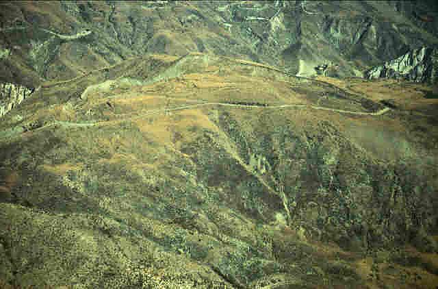 Figure 5.
Oblique aerial view of the San Martinez Grande landslide (plate 2).
Figure 5.
Oblique aerial view of the San Martinez Grande landslide (plate 2).The headwall area is composed of a complex network of south-facing (downslope) scarps 15-20 m high and, immediately to the south of this, a network of multiple, somewhat lower scarps facing north (upslope). The graben complex formed by these two sets of scarps extends east-west parallel to the head scarp and is about 80-100 m wide (fig. 6). Net lateral displacement across this graben is about 5-10 m. The failure surface passes beneath the top of the ridge and daylights on the opposite, north-facing slope; thus, the ridge top moved downward several meters as part of the landslide mass.
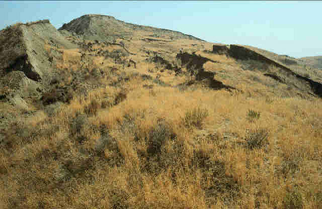 Figure 6.
Main scarp area of San Martinez Grande landslide. Slide moved left to right in the photo. Scarps on left side
are 15-20 m high and face downslope; scarps on right side face upslope.
Figure 6.
Main scarp area of San Martinez Grande landslide. Slide moved left to right in the photo. Scarps on left side
are 15-20 m high and face downslope; scarps on right side face upslope.The landslide toe formed in a fairly flat area that appears to be a graben at the head of the much larger, ancient slide complex. The toe is defined by multiple recumbent folds that formed small ridges 40-80 cm high; this suggests that total displacement in this portion of the slide is no more than 1-2 m (fig. 7), almost an order of magnitude less than at the head.
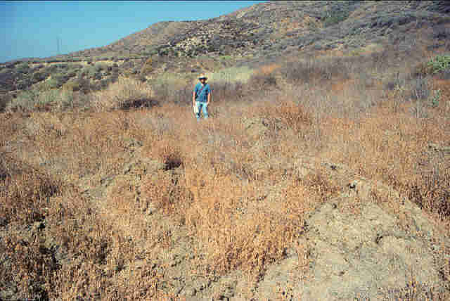 Figure 7.
Small ridges at toe of San Martinez Grande landslide.
Figure 7.
Small ridges at toe of San Martinez Grande landslide.
Rancho Camulos Landslide. The second-largest landslide triggered or reactivated by the earthquake is the Rancho Camulos slide, which lies 4.5 km west of the San Martinez Grande landslide along the same ridge in the Pico Formation (plate 2).
This failure is a preexisting earth slide/flow that was reactivated by the strong shaking. The slide is 600 m long, 200 m wide, and has an estimated average thickness of 50 m, which yields a volume of about 6X10E6 m³ (fig. 8). The main scarp reaches 25-30 m in height and exposes moist, clayey material having weathering characteristics that indicate high montmorillonite content (fig. 9).
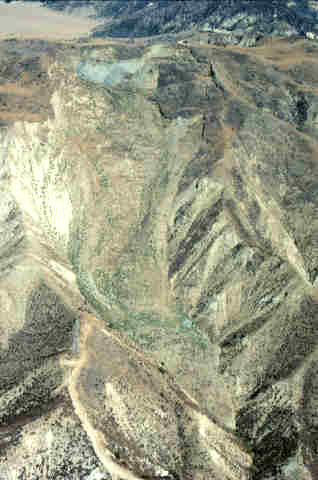 Figure 8.
Oblique aerial view of Rancho Camulos landslide (plate 2).
Figure 8.
Oblique aerial view of Rancho Camulos landslide (plate 2).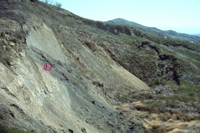 Figure 9.
Main scarp of Rancho Camulos earth slide/flow (plate 2); slide moved from left to right in photo. Man standing
in left center , inside the circle, shows scale; the earthquake triggered 25-30 m of displacement on this scarp.
Figure 9.
Main scarp of Rancho Camulos earth slide/flow (plate 2); slide moved from left to right in photo. Man standing
in left center , inside the circle, shows scale; the earthquake triggered 25-30 m of displacement on this scarp.The walls of the valley containing the slide have shattered ridge crests and incipient failures on their slopes, which indicates a very high level of strong shaking in the area. The toe of the slide is a deformed, lobate mass tens of meters thick that fills the canyon bottom. The Rancho Camulos slide appears to have been active as recently as a year before the earthquake during the exceptionally wet winter of 1992-1993. The earthquake shaking both reactivated and enlarged the preexisting slide, and fissures extending across ridges that bounded the preexisting slide indicate that the enlargement was so extensive that it involved adjacent drainages. Within the main body of the slide, ridges and ravines having local relief of tens of meters are offset by landslide movement, which implies a deep basal shear surface of perhaps 100 m in the upper parts of the slide complex.
Loma Verde Landslide. The Loma Verde landslide is large, deep-seated landslide in the mountains north of the Santa Clara River (plate 2). This block slide in Pliocene and Pleistocene very weakly cemented sandstone is 250 m long, 200 m wide, and about 20 m thick, which yields a volume of 1X10E6 m³ (fig. 10).
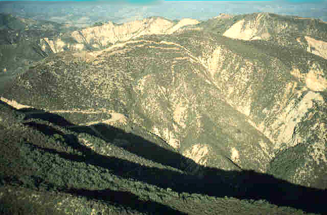 Figure 10.
Loma Verde landslide (plate 2). Light-colored, arcuate scarps visible in upper center of photo each had 1-2
m of displacement.
Figure 10.
Loma Verde landslide (plate 2). Light-colored, arcuate scarps visible in upper center of photo each had 1-2
m of displacement.The head of the landslide contains multiple scarps, each showing 1-2 m of lateral displacement; total displacement across these scarps is 5-10 m. The northwest part of the toe is well developed and is defined by a bulging front a few meters high and by thrust faults exposed about halfway between the ridge top and valley bottom (total relief of about 100 m); the southeast part of the toe extends farther downslope to near the valley bottom; it is more subtle and is not continuously traceable. The narrow ridge above the main scarp is thoroughly shattered (fig. 11) over a length of hundreds of meters (well beyond the margins of the slide), which indicates extreme shaking here, also.
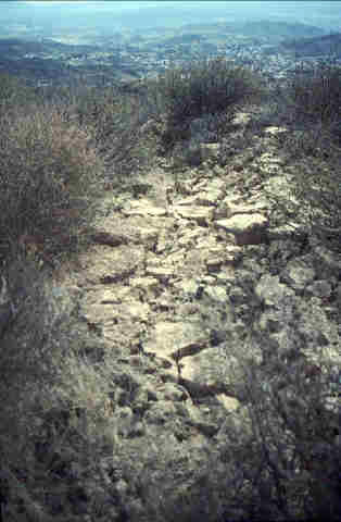 Figure 11.
Shattered ridge above main scarp of Loma Verde landslide. Such shattered ground indicates high levels of ground
shaking.
Figure 11.
Shattered ridge above main scarp of Loma Verde landslide. Such shattered ground indicates high levels of ground
shaking.
Ramona Oil Field Landslide. A long, narrow earth slide/flow in the Ramona Oil Field, about 2 km north-northeast of the San Martinez Grande landslide (plate 2), was reactivated by the earthquake and seriously damaged part of the oil field. The slide is 600 m long, 100-150 m wide, and about 10-15 m deep, yielding a volume of about 1X10E6 m³ (fig. 12).
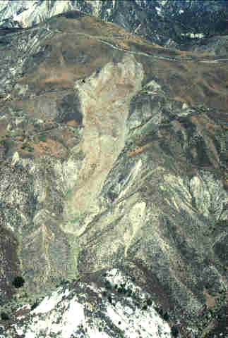 Figure 12.
Oblique aerial view of Ramona Oil Field landslide (plate 2). Small, black object on margin of slide at upper
left is tank shown in figure 13.
Figure 12.
Oblique aerial view of Ramona Oil Field landslide (plate 2). Small, black object on margin of slide at upper
left is tank shown in figure 13.Renewed slumping and downslope movement in the upper part of the slide damaged a road, severed a well pipe, toppled an oil storage tank, and left a well pump suspended in space over the recently displaced slide mass (fig. 13), which moved as much as 15-25 m down a 20-25º slope.
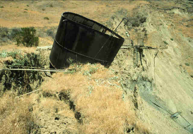 Figure 13.
Oil tank toppled by reactivated movement near head of Ramona Oil Field landslide.
Figure 13.
Oil tank toppled by reactivated movement near head of Ramona Oil Field landslide.
Las Virgenes Canyon Landslide. Few landslides were triggered in the Simi Hills, west of Canoga Park and south of Simi Valley (plate 1), because the rock there is primarily well-cemented sandstone. One notable exception is the Las Virgenes Canyon landslide, near a recent subdivision at the head of Bell Canyon, which was reactivated by earthquake shaking. The reactivated slide is about 350 m long, 325 m wide, and 35 m deep; it involves approximately 4X10E6 m³ of material within a sliver of the Topanga Formation exposed along a northeast trending unnamed fault within the surrounding Monterey/Modelo Formation (fig. 14). Nearly the entire landslide appears to have reactivated by slumping and moving 30-50 m downslope. Rock exposed in the nearly vertical main scarp is blocky and appears well cemented.
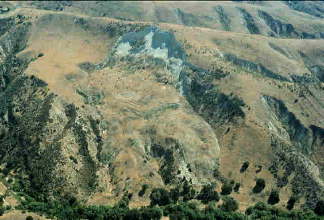 Figure 14.
Oblique view of Las Virgenes Canyon landslide (plate 1).
Figure 14.
Oblique view of Las Virgenes Canyon landslide (plate 1).
Deep-Seated Landslides in the Santa Monica Mountains. The earthquake shaking reactivated several ancient block slides in the central and eastern Santa Monica Mountains, primarily between Topanga Canyon and Hollywood (plate 1). This area, in general, is densely developed; thus, many of these slides damaged homes and roads. Unfortunately, the dense development generally made it impossible to precisely determine the geometric extent of individual landslides. Failures commonly involved blocks of weakly cemented, deeply weathered Tertiary sedimentary rock, measuring several tens of meters across, that slipped a few centimeters to several decimeters along bedding planes. One particularly notable example is along Mulholland Drive about 1.5 km east of I-405. Here, bedding-plane slip displaced a landslide block a few decimeters northward, which offset Mulholland Drive and created a series of scarps in the front yard of a home on the mountain crest (fig. 15).
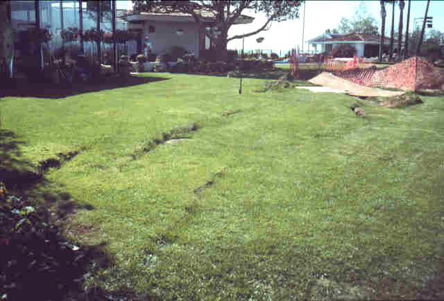 Figure 15.
Scarps at head of block slide in front yard of residence along Mulholland Drive, 1.5 km east of I-405.
Figure 15.
Scarps at head of block slide in front yard of residence along Mulholland Drive, 1.5 km east of I-405.
Shaking-induced settlement and slumping of cut-and-fill embankments were common, especially within some of the subdivisions in the Santa Clarita Valley, where fill settlements and displacement along cut/fill contacts damaged numerous residences. Even though the fills presumably were compacted according to strict codes, shaking was severe enough within the area to induce enough displacement in some fills to severely damage many homes and make them unsafe. Rebuilding on lots that failed in the earthquake has required significant mitigation efforts and considerable expense. In some cases, deep pilings have been used to stabilize building sites before reconstruction proceeded. In some areas of the Santa Monica Mountains, ancient landslides were covered with artificial fill when areas were developed, and settlement or movement of fill, possibly related to reactivation of underlying landslides, severely damaged homes and infrastructure.

![]() U.S. Department of the Interior |
U.S. Geological Survey
U.S. Department of the Interior |
U.S. Geological Survey
URL: http://pubsdata.usgs.gov/pubs/of/1995/ofr-95-0213/DISTRIB.HTML
Page Contact Information: GS Pubs Web Contact
Page Last Modified: Wednesday, 23-Nov-2011 14:29:16 EST