Open-File Report 96-738
|Table of Contents|Previous Page|Next Page|
VOLCANIC ACTIVITY, KAMCHATKA PENINSULA, RUSSIA
BEZYMIANNY VOLCANO
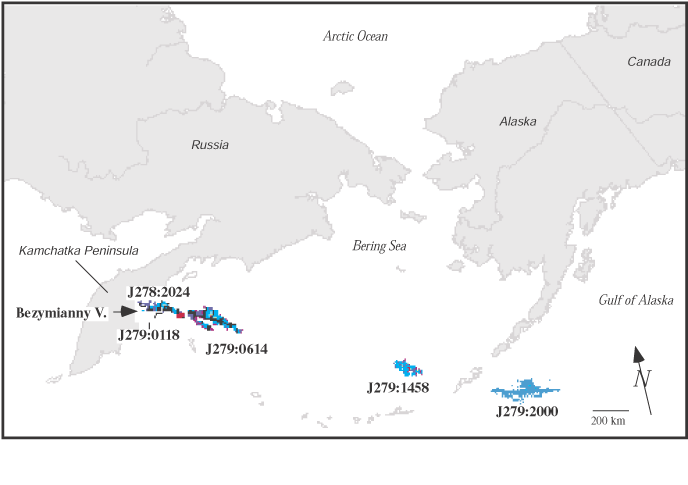
55°58'N 160°36' E 2,800m (9187 ft) Kamchatka Peninsula, Russia Explosive eruption on 10/05/95; 2-3 mm ashfall 50 km away; ash plume carried 5000 km downwind across north Pacific air routesBezymianny Volcano erupted on October 5, 1995 at 0500 Kamchatka Standard Time (KST) (Julian day 278, 1700 UTC). The eruption cloud was observed first at 2100 UTC by AVO during routine inspection of a 2024 UTC AVHRR satellite image. Image analysis indicated that the cloud top was at about 33,000 feet ASL and extending to the ENE for over 100 km. The eruption was confirmed by KVERT volcanologists about 4 hours later. Ashfall amounting to 2-3 mm was reported at Kliuchi, about 50 km NNE. Satellite images recorded on October 6 showed the plume traveling ESE across major north Pacific aircraft (NOPAC) and Russian Far East (RFE) aircraft routes (fig. 7). The eruption disrupted flight plans for about 15 aircraft. The ash cloud was last visible on satellite imagery at 2000 UTC October 6 when it was 5000 km ESE of Bezymianny, near the Aleutian Island of Unalaska (figs. 8, 9). The last ash-producing eruption began in October 1993 with intermittent activity through November 1994 (Smithsonian Institution, 1993; 1994).
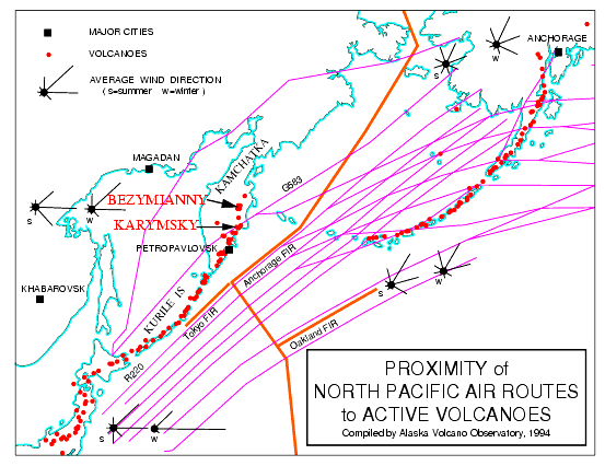
Figure 7. Location map for Bezymianny and Karymsky volcanoes on Kamchatka Peninsula and proximity to NOPAC and RFE air routes.AVO scientists were first to identify an eruption in progress and to issue warnings to FAA, NWS, and air carriers of the potential hazard to aircraft. Successive satellite images were analyzed over the next few days to track the ash cloud and information about seismicity and ashfall was obtained by communication with KVERT volcanologists. AVO issued Information Releases on Thursday, October 5 (1700 ADT and at 2300 ADT) and on Friday, October 6 (1430 ADT).
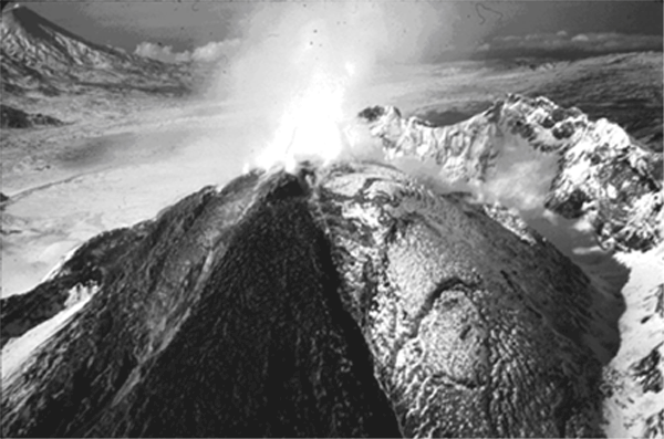
In October 1955, Bezymianny Volcano emerged from a 900-1000 year period of quiescence in October 1955 with an explosive eruption that culminated in the catastrophic failure of the eastern flank, which produced a large debris avalanche and lateral blast, very similar to what later occurred at Mount St. Helens in 1980 (Voight and others, 1981). Since then, lava extrusion has produced a dome that periodically collapses generating pyroclastic flows (fig. 10). Over 30 eruptions have been documented since 1956, making it one of the most active volcanoes on the Kamchatka Peninsula (Simkin and Siebert, 1994).
Figure 8. Composite of AVHRR satellite images beginning at Julian Day 278 (J278: October 5) 2024 UTC showing an eruption cloud from Bezymianny Volcano, Kamchatka Peninsula, Russia. The ash cloud traveled east-southeast across NOPAC and RFE air routes at an altitude of about 33,000 feet ASL. Figure by Ken Dean, AVO, Geophysical Institute, University of Alaska, Fairbanks.
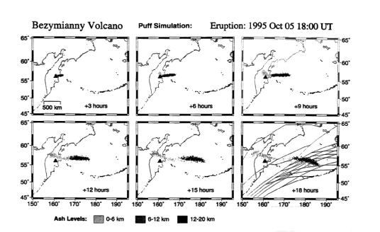
Figure 9. Simulated images generated when satellite observations were not available from a tracking model [called PUFF] showing the location of airborne ash ejected from Bezymianny Volcano. Location of the ash is depicted in three hour time intervals and at three altitudes. The final frame shows NOPAC and RFE air routes. Figure by Craig Searcy, Geophysical Institute, University of Alaska, Fairbanks.
Figure 10. Bezymianny summit dome and lava flow. Photo by Tom Miller, 9/90.
KARYMSKY VOLCANO
54°03' N 159°27' E 1,536 m (5,040ft) Kamchatka Peninsula, Russia
Increased seismicity in mid-April, 1995; eruption in early 1996
The Institute of Volcanic Geology and Geochemistry in Russia reported increased seismicity in mid-April under Karymsky volcano, located about 130 km (80 mi) north of Petropavlovsk-Kamchatsky near the trans-Kamchatka air route (figs. 7, 11). The volcano usually issues a continuous steam plume. Karymsky is one of the most active volcanoes on the Kamchatkan Peninsula with at least 26 eruptions recorded this century. The last eruptive period ended in 1982 (Simkin and Siebert, 1994).
The increase in seismicity was noted in the AVO weekly update of April 14, 1995, and in the GVN Bulletin (Smithsonian Institution, 1995g). Satellite images of Karymsky were scanned daily for the next two months for hot spots and signs of eruptive activity.
The increased seismicity in 1995 culminated with an explosive eruption that began on January 1, 1996 at the north end of Karymsky Lake and then shifted to the volcano's summit where a new crater formed adjacent to an old crater.
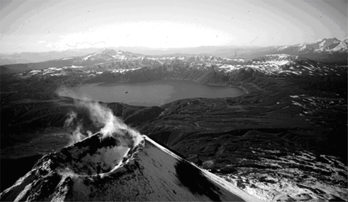
Figure 11. Karymsky volcano and Karymsky Lake. The 5-km-diameter lake lies about 5 km south of the volcano and occupies the late-Pleistocene Akademia Nauk caldera. Photo by Tom Miller, 9/90.Reviewers
Diedra Bohn
Don Richter
|Table of Contents|Previous Page|Next Page|

![]() U.S. Department of the Interior |
U.S. Geological Survey
U.S. Department of the Interior |
U.S. Geological Survey
URL: http://pubsdata.usgs.gov/pubs/of/1996/0738/kamchatka.html
Page Contact Information: GS Pubs Web Contact
Page Last Modified: Wednesday, 07-Dec-2016 16:07:49 EST