Mineral Resources Program
The U.S. Geological Survey's mineral resource assessments predict potential for mineral deposits and geo-environmental models predict environmental affects from mineralized bedrock. These tools can be combined to rapidly screen large areas and establish priorities for further studies. The following example shows how information from mineral resource assessments can be combined with information from geoenvironmental models to delineate areas and establish priorities for further studies in the Southern Appalachians Man in the Biosphere Ecosystem (SAMAB) region. The SAMAB region, which was designated by the United Nations Scientific, Educational, and Cultural Organi zation (UNESCO) in 1988, as a regional biosphere reserve, covers the Appalachian part of six states: Virginia, Tennessee, North Carolina, South Carolina, Georgia, and Alabama.
The U.S. Geological Survey's National Mineral Resource Assessment, which was compiled at a scale of 1:500,000 and 1:1,000,000, provides digital information on the types of deposits that are known and that might be present in an area for five important metals: gold, silver, copper, lead, and zinc (Ludington and Cox, 1996). For this example, only copper, lead, and zinc are included. These metals are important in our economy, have been produced widely and extensively, and can cause a range of environmental affects ranging from benign to very hazardous, depending on deposit type.
Mineral resource assessments provide information about the types of rocks and mineral deposits that are present in an area, the parts of the area that are favorable for the occurrence of additional mineral deposits, and estimates the probable amounts of undiscovered mineral resources. Mineral resource assessments answer the questions of what, where, and how much. The mineral resource assessment method is based on mineral deposit models, which describe a groups of deposits with similar characteristics and provide the link between deposit type and geologic environment (Cox and Singer, 1986). The models are based on worldwide literature and observation, and they describe the common geologic attributes of deposits and the environments in which they are found. Grade and tonnage models consist of frequency distributions of the grade and size of the individual deposits that serve as examples for that deposit type. A mineral resource assessment is carried out by an interdisciplinary team of geoscientists who review the geology of an area, select appropriate deposit models, and delineate permissive tracts for each type of deposit. The permissive tracts are defined by the geologic environments of formation described in the deposit model. Permissive tracts are defined as those for which the probability of deposits occurring outside the tract is negligible.
Within the SAMAB region the National Mineral Resource Assessment identified permissive tracts for 5 deposit types: Kuroko-type massive sulfide, Besshi-type massive sulfide, sedimentary exhalative zinc-lead, Appalachian zinc, and sandstone hosted lead-zinc, as described in Cox and Singer (1986).
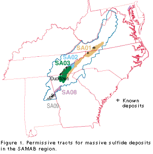
The two types of massive sulfide
deposits, Kuroko and Besshi, have
similar characteristics, and are combined
on figure 1. Both types form as sheetlike
or lens shaped concentrations of copper,
lead, and zinc sulfides with high pyrite
contents and are spatially associated with
volcanic rocks. Five tracts were defined,
each of which has a different
combination of geologic characteristics
that are considered favorable for the
occurrence of massive sulfide deposits.
Three of the permissive tracts (SA01,
SA02, and SA03) are wholly within the
SAMAB region, and two (SA08 and
SA09) are partly within the SAMAB
region. Several deposits are known in
the permissive tracts including deposits
in the Ducktown (Copper Hill) district.
For tract SA01 the numerical estimates
of the number of undiscovered deposits
at the 90th, 50th, and 10th percentile
confidence levels are 1, 3, and 5,
respectively (table 1) (Slack, 1996).
That is, the assessment team estimated
that the probability of less than one
undiscovered deposit at a depth of 1 km
or less in tract SA01 was very low; they
considered it likely that 3 undiscovered
deposits exist, and unlikely that there
were more than 5 undiscovered deposits.
From this analysis, it is concluded that
there is a relatively high probability of
the occurrence of one of more undiscovered massive sulfide deposits in tract
SA01 Estimates for the other tracts
indicate that the probability of undiscovered massive sulfide deposits is high
for SA03 and SA08 (Slack, 1996; Klein,
1996). No estimates were made for
tracts SA02 and SA09 because the team
considered the probability of undiscovered deposits to be less than one
percent, but not negligible.
Continuing with the example, the severity of environmental hazards associated with massive sulfide deposits is then estimated.
| Massive Sulfide | Probability | ||
|---|---|---|---|
| Tract | 90% | 50% | 10% |
| SA01 | 1 | 3 | 5 |
| SA02 | No estimate | ||
| SA03 | 1 | 3 | 5 |
| SA08 | 2 | 5 | 10 |
| SA09 | No estimate | ||
Geo-environmental models for mineral deposit types characterize the environmental signatures of rocks, soils, sediments, and waters prior to being mined (Plumlee and Nash, 1995). Geo-environmental models also describe and predict the environmental effects likely to result from mining, that is, recovering the metals from such a deposit. Geo-environmental models include factors such as the character and size of mine workings, the character and mass of waste products, and the processes of their interactions with the environment. The geo-environmental model for massive sulfide deposits is the most likely of all deposit types to have associated environmental problems (Taylor and others, 1995). Drainage waters associated with massive sulfide deposits can be highly acid, can have extremely high dissolved metal contents, and are generally in host rocks that have low acid buffering capacity. The deposits are most problematic in arid climates, but the iron- and base metal sulfide minerals that are present in massive sulfide deposits are unstable under normal oxidizing conditions and represent potential sources of highly acid and metal rich drainage in any environment.
In the geologic setting where massive sulfide deposits form, iron and base metal sulfide rich concentrations occur not only in mineral deposits where concentrations are sufficient to be mined, but in lateral extensions of these deposits and in concentrations that are not rich enough to mine, but can cause acidity and elevated level of metals in stream water flowing over undisturbed rock. Oxidation of pyrite (iron sulfide) releases Fe and trace metals along with SO4 2- and H+ and may increase acidity in ground and surface waters if not buffered. Disturbance of sulfide rich zones through human activities increase the area of sulfide that are exposed to near surface conditions, which in turn increases the rate of the oxidation reaction and potential for acid production.
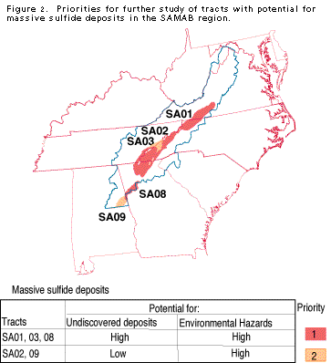
Therefore, the tracts identified as having high potential for massive sulfide deposits
(SA01, SA03, and SA08) also have a high level of environmental risk associated with
disturbance of pyrite rich zones (fig. 2). For this example the areas with high potential
for the occurrence of mineral deposits with high levels of environmental risk are assigned
priority level of 1, and warrant a more detailed geologic evaluation. For the high priority
areas, lithologic maps can be used to more closely delineate areas that have potential for
generating acidic and metal rich waters. Geologic and geochemical studies of areas with
potential for development can be used to pinpoint sulfide rich zones and to establish
baseline data. For areas of lower potential for the occurrence of massive sulfide deposits
(SA02 and SA09), the environment risk would be the same, but because the probability of
occurrence of these deposits is low, the priority for more detailed studies is lower than for
areas where probability of occurrence is high. For the purpose of this analysis, the
environmental risk is considered moderate and the tract is assigned priority level of 2.
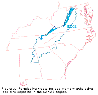
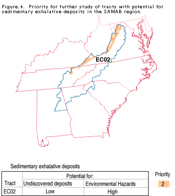
A large permissive tract for sedimentary exhalative deposits is partly within the
SAMAB area (EC02, fig. 3). No estimate was made of the number of undiscovered
deposits, because only a small part of the tract is within the SAMAB area and the
assessment team considered the probability of undiscovered deposits to be low but not
negligible based on the geologic environment (Clark, 1996). The mineralogic
characteristics of sedimentary exhalative deposits are similar to those of massive sulfide
deposits, so that if a deposit were to exist the environmental risk might be high (Kelley
and others, 1995). Therefore, the overall level of potential environmental hazard is
considered to be moderate and the tract is assigned a priority level of 2 (fig. 4).
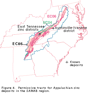
The SAMAB area includes Appalachian zinc type deposits of the East Tennessee
district. Three tracts (EC04, EC05, and EC06) that are considered permissive for the
occurrence of undiscovered Appalachian zinc deposits are partly or mostly within the
SAMAB area (fig. 5). The numerical estimates of the number of undiscovered deposits
in tract EC06 at the 90th, 50th, and 10th percentile confidence levels are 3, 6, and 8,
respectively (Table 2)(Clark and others, 1996). Therefore, for this analysis, there is a
high probability of the occurrence of undiscovered deposits in tract EC06. Estimates for
EC05 are less, but the assessment team estimated one undiscovered deposit at the 50
percent confidence level. Therefore, for these two tracts, the probability of the existence
of at least one deposit is very likely. For tract EC04 the team considered the probability
of undiscovered deposits to be less than one percent, but not negligible.
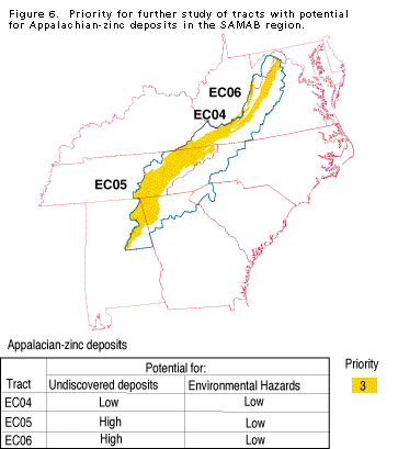
The potential impact of Appalachian zinc type deposits predicted by the
geoenvironmental model differs significantly from the potential impact of massive
sulfide deposits (Leach and others, 1995). The acid-generating potential is low because
iron sulfides, which are the most common acid-generating minerals, are absent or present
in minor amounts in Appalachian zinc deposits. Most of the deposits are low in lead;
some are lead-free. In addition, the host rocks are carbonates, which have a high
buffering capacity, so that even if acid drainage develops, it may be neutralized by the
surrounding rocks. However, climatic conditions and soil properties (acidic vs. neutral)
can interact to increase potential environmental problems. Even though the probablility
of future mining is high in these tracts, the environmental impacts may be mainly related
to physical disturbances with low to moderate geochemical risks from bedrock sources.
For example, water detailed geologic evaluation.
| Appalachian zinc | Probability | ||
|---|---|---|---|
| Tract | 90% | 50% | 10% |
| EC04 | No estimate | ||
| EC05 | 0 | 1 | 3 |
| EC06 | 3 | 6 | 8 |
For the quality problems in the New River of trace metals and locally acidification, may result in part from past mining activities in the Austinville-Ivanhoe district (Leach and others, 1995). The priority for additional information on environmental risk is considered to be lower than for the other areas, but not negligible, so tracts EC05 and EC06 are assigned a priority level of 3 (fig. 6).
The only other type of copper, lead,
or zinc deposit for which permissive
tracts are delineated in the SAMAB is
sandstone hosted lead-zinc. For this
deposit type, the probability of undiscovered deposits is less that one percent,
but not negligible (Slack and others,
1996). Known deposits contain lead
sulfides, but do not usually contain iron
sulfides, so the environmental risk of
these deposits, if they occurred, would
not be significant enough for further
study in this analysis.
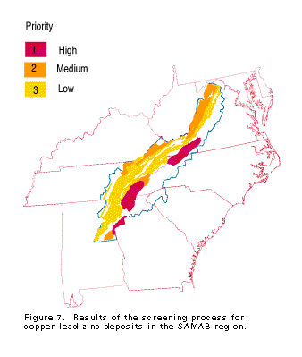
The results of the screening process are combined on a map showing the priorities for areas at risk for potential environmental hazards associated with the occurrence of undiscovered copper, lead, and zinc deposits or concentrations in the SAMAB region (fig. 7). Additional information on the deposits, both known and undiscovered, and on gold and silver deposits can be derived from the National Mineral Resource Assessment. Regional mineral resource investigations and site specific studies can be used to provide additional information, including lithologic, geochemical, and geophysical maps and information about other types of mineral deposits. For high-priority areas with high potential for environmental hazards, if adequate information is not available, new geologic or geochemical baseline studies should be considered to provide adequate information for land use decisions and to develop guidelines for mitigation and remediation associated with potential mining or other disturbances to land and water.