|
|
INTRODUCTION
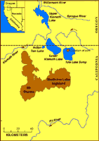
Tule Lake basin is a remnant of a much larger ancient lake system that once covered a large area of north-central California and south-central Oregon east of the Cascade Range. Most of the present lake basin has been drained for agriculture. In 1982 the U.S. Geological Survey collected a sequence of cores from Tule Lake Sump (Figure 1) near the town of Tulelake that resulted in almost continuous recovery of the upper 334 m of the estimated 550 m of lacustrine sediment in the basin (Adam and others, 1989). The base of the cored interval is within the Gauss normal-polarity paleomagnetic chron and is estimated to be about 3.0 My old (Reike and others, 1992). Samples of sediment were collected for studies of pollen, ostracodes, diatoms, tephra, paleomagnetics, and geochemistry. This report presents the results of the geochemical investigations.
|
|
| AccessibilityFOIAPrivacyPolicies and Notices | |
| |
|