The Division of Geology and Earth Resources (DGER) is Washington's state geological survey and a division of the Department of Natural Resources (DNR). The DNR began operating a geographic information system (GIS) in 1983. This system is used for a variety of land-management activities and includes such coverages as political boundaries, drainage and open water, transportation grid, section-township-range grid, land ownership, land cover-land use, and soils. DGER is preparing statewide digital geology coverages to add to the DNR GIS database.
The GIS runs on a platform of 67 Sun workstations with Solaris 2.5 as the operating system. There are over 700 users, and the main applications software is Arc/Info and Oracle. The system includes more than 200 GB of data storage and hundreds of X-Terminals, printers, plotters, and digitizers. DGER accesses this system through five X-Terminals (or emulators) and four digitizers. We produce plotted maps through a central facility located in the same building. Overall system administration, operation, training, and maintenance are department-level functions, but DGER is financially responsible for equipment upgrades and replacements for our terminals and digitizers and the "local" server.
Also in 1983 DGER began a program to reissue the state geologic map. Program objectives are: (1) Recompile and republish the state geologic map at 1:250,000 scale in full color in four quadrants using age-lithologic geologic unit symbology; (2) Compile the geology first at 1:100,000 scale and simplify it for presentation at 1:250,000; (3) Release the 1:100,000 maps as open-file reports with supporting descriptions of map units, index map(s) showing sources of geologic map data, references, and, in some reports, radiometric or other ages and geochemistry; and (4) If a U.S. Geological Survey (USGS) 1:100,000 geologic quadrangle map exists, use it instead of recompiling the quadrangle. Quadrant boundaries for the 1:250,000 maps are 47 deg 15 min N. and 120 deg 30 min W.
The 1:100,000 compilation geologic maps for the southwest quadrant of Washington were released in 1986 and 1987, and the southwest quadrant of the 1:250,000 state geologic map was printed in 1987. On this first set of 1:100,000 maps the geologic unit symbols differed from those used on the 1:250,000 map. By the time the 1:100,000 maps for northeastern Washington were being compiled, we concluded it would be easier to use the same basic symbology for both the 1:100,000 and 1:250,000 maps, arriving at the 1:250,000 unit symbols by dropping subscripts (which denote named geologic units) from the 1:100,000 unit symbols. The 1:100,000 geologic maps for the northeast quadrant were released in 1990, and the 1:250,000 geologic map was printed in 1991. The 1:100,000 geologic maps for the southeast quadrant were open-filed in 1993 and 1994, and the 1:250,000 geologic map will be printed by June 1997.
Work continues on 1:100,000 compilation geologic maps for the northwest quadrant. We hope to release all these maps in 1998 and publish the 1:250,000 geologic quadrant map promptly thereafter. However, budget cuts over the last five years have had serious effects on our state geologic map program, and we cannot predict map completion dates. Eight USGS 1:100,000 geologic maps (fig. 1) are available, as is the DGER 1:100,000 map for the Twisp quadrangle.
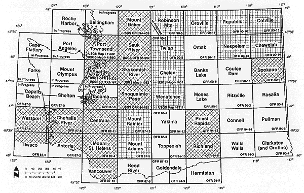
Figure 1. Status of 1:100,000 geologic mapping in Washington. For completed partial and whole quadrangles, the publication number is shown. "OFR" denotes a DGER open-file report; "USGS OFR" denotes a USGS open-file report; "USGS Map" denotes a USGS Miscellaneous Investigations Series Map, or I series. "In Progress" indicates that the geological compilation work is still under way. The crosshatch pattern marks the 17 quadrangles for which digital products are to be finished by June 30, 1997, and the grid pattern marks those to be finished June 30, 1998, both of these projects under USGS STATEMAP contracts.
The DGER geologic maps were prepared using scale-stable copies of USGS topographic quadrangle maps as base maps. For most maps we drafted the geologic information on scale-stable overlays that were photographically composited with the base maps to produce master geologic maps; these are copied for distribution. The DGER scale-stable composites or overlays are the data sources for the digital geologic coverages that we are currently preparing. For the USGS geologic maps, we typically work from digital files provided by the authors. At minimum, a change of geologic unit symbols is required, so that the USGS maps have the same geologic unit symbology as the DGER maps.
DGER began working toward statewide 1:100,000 digital geologic coverage about four years ago when a contract from the Washington Department of Ecology allowed us to develop a data structure and to digitize the Richland and Priest Rapids quadrangles in eastern Washington. In the two years that followed that contract, we partially digitized several 1:100,000 quadrangles in southwestern Washington, using "spare" cartographer time.
Support from the STATEMAP component of the USGS National Cooperative Geologic Mapping program has radically improved the rate at which we generate digital geology. The initial STATEMAP contract calls for delivery of hard copy and digital geology for 17 1:100,000 quadrangles by June 30, 1997. The quadrangles were chosen on the basis of demand for digital geology, significant population, significant land-use issues, and at least partial availability of digital geologic information. These quadrangles are shown on figure 1. This contract requires a 50:50 match and has a total budget of $90,204. The USGS recently awarded us a second STATEMAP contract that calls for 11 more quadrangles by June 30, 1998 (Fig. 1). This contract also requires a 50:50 match and has total funding of $90,204. Two additional years of STATEMAP support should allow us to complete the remaining 24 full or partial quadrangles in Washington.
We will use about 17 months of cartographer and geologist time to complete the first 17 digital quadrangle maps, and another 17 to complete the second contract's 11 quadrangles. The difference is that some digital information was available for the first 17 quadrangles and several are only partial quadrangles, whereas 9 of the 11 quadrangles of the second contract will be digitized from hard copy and all the quadrangles are full size. These time estimates include about 3 months of geologist time for each contract to prepare materials for digitizing, convert old unit symbols to new ones where necessary, and review draft products. The remaining 14 months are spent digitizing, attributing, reviewing previous digital data and correcting errors and omissions, and editing the digital information. Both cartographers and geologists contribute to the GIS tasks, with one cartographer concentrating on system development and design, training others, problem solving, and overall quality control, and one geologist and a second cartographer doing digitizing, attributing, editing, and error correction.
Our focus so far has been on generating statewide digital geology and supporting data. We have not used the digital geology for analysis, but we expect that many customers will do so.
The 1:100,000 quadrangle corner coordinates are fixed in state plane coordinates in the DNR GIS and provide the control points to which all geologic data are registered. For data entry, scale-stable originals are coordinated to the quadrangle corners to a root-mean-square error of 0.003 or better. Each 1:100,000 quadrangle is assigned a row-column grid number, and this number is the name of the directory in which all the digital data for that quadrangle are stored. For example, the Cape Flattery quadrangle is in row 2 and column 1, so it gets the number Q201; Clarkston is Q608 (row 6, column 8). See Figure 1 for quadrangle location.
The digital information for each quadrangle is stored in a set of seven Arc/Info coverages with associated INFO data files, all stored in that quadrangle's directory. The coverages contain different kinds of geologic map data, as shown in table 1. Statewide coverages are obtained by tiling the 1:100,000 quadrangles. The GUNIT, GFAULT, GFOLD, and GDIKE coverages have arc attribute tables with data items as shown in table 2. The GUNIT, GVENT, GATTUD, and GDTSMPL coverages have point or polygon attribute tables with data items as shown in table 3.
|
Coverage |
Type |
Content |
|
GUNIT |
line and polygon |
contacts, quadrangle boundaries, open-water boundaries, glacier boundaries, geologic unit polygon labels, open-water polygon labels, glacier polygon labels |
|
GFAULT |
line |
faults |
|
GFOLD |
line |
fold axes |
|
GDIKE |
line |
dikes |
|
GVENT |
point |
eruptive centers |
|
GATTUD |
point |
structure symbols (strike and dip, foliation, lineation, etc.) |
|
GDTSMPL |
point |
fossil and radiometric sample locations |
Table 2. Arc-attribute-table data items. X, present; --, absent.
|
|
|
Coverage |
|||
|---|---|---|---|---|---|
|
Item |
Description |
GUNIT |
GFAULT |
GFOLD |
GDIKE |
|
FNODE# |
from-node number |
X |
X |
X |
X |
|
TNODE# |
to-node number |
X |
X |
X |
X |
|
LPOLY# |
left-polygon number |
X |
X |
X |
X |
|
RPOLY# |
right-polygon number |
X |
X |
X |
X |
|
LENGTH |
length |
X |
X |
X |
X |
|
GUNIT# |
...# is a system-assigned number identifying each arc segment |
X |
-- |
-- |
-- |
|
GFAULT# |
-- |
X |
-- |
-- |
|
|
GFOLD# |
|
-- |
-- |
X |
-- |
|
GDIKE# |
|
-- |
-- |
-- |
X |
|
GUNIT-ID GFAULT-ID GFOLD-ID GDIKE-ID |
...-ID is a user-assignable number identifying arc segments; used to populate other data items in the database |
X |
-- |
-- |
-- |
|
-- |
X |
-- |
-- |
||
|
-- |
-- |
X |
-- |
||
|
|
-- |
-- |
-- |
X |
|
|
GCNTCT.ID GFAULT.ID GFOLD.ID GDIKE.ID |
... .ID is a number identifying all arc segments of a particular linear feature; used to distinguish that feature from any other linear feature; relates to a data file containing feature names |
X |
-- |
-- |
-- |
|
-- |
X |
-- |
-- |
||
|
-- |
-- |
X |
-- |
||
|
-- |
-- |
-- |
X |
||
|
GCNTCT.TYPE.CD GFLTSEG.TYPE.CD GFOLDSEG.TYPE.CD GDIKESEG.TYPE.CD |
... .TYPE.CD is a user-assignable number identifying the arc segment type (certain contact, glacier boundary, normal fault, queried syncline, etc.) |
X |
-- |
-- |
-- |
|
-- |
X |
-- |
-- |
||
|
-- |
-- |
X |
-- |
||
|
-- |
-- |
-- |
X |
||
|
GFLTSEG.NO |
...SEG.NO is a sequential number assigned to each arc segment to distinguish it from other segments of the same linear feature |
-- |
X |
-- |
-- |
|
GFOLD.SEG.NO |
-- |
-- |
X |
-- |
|
|
GFLTSEG.ID |
...SEG.ID is a unique, system-assigned number attributed to each arc segment |
-- |
X |
-- |
-- |
|
GFOLDSEG.ID |
-- |
-- |
X |
-- |
|
|
FLTCNT |
"Y" if fault segment separates polygons with different labels; otherwise "N" or blank |
X |
X |
-- |
-- |
|
GMAP.ID |
The row-column code for the quadrangle |
X |
X |
X |
X |
|
GUNIT.LABEL.CD |
The geologic unit age-lithologic symbol |
X |
-- |
-- |
X |
|
DIKE.NM |
Dike name |
-- |
-- |
-- |
X |
Table 3. Point- or polygon-attribute-table data items. X, present; --, absent.
|
|
|
Coverage |
|||
|---|---|---|---|---|---|
|
Item |
Description |
GUNIT |
GFAULT |
GFOLD |
GDIKE |
|
AREA |
polygon area |
X |
X |
X |
X |
|
PERIMETER |
length of polygon perimeter |
X |
X |
X |
X |
|
GUNIT# |
...# is a system-assigned number dentifying each point or polygon |
X |
-- |
-- |
-- |
|
GVENT# |
-- |
X |
-- |
-- |
|
|
GATTUD# |
|
-- |
-- |
X |
-- |
|
GDTSMPL# |
|
-- |
-- |
-- |
X |
|
GUNIT-ID |
...-ID is a user-assignable number identifying points or polygons; used to populate other data items in the database |
X |
-- |
-- |
-- |
|
GVENT-ID |
-- |
X |
-- |
-- |
|
|
GATTUD-ID |
-- |
-- |
X |
-- |
|
|
GDTSMPL-ID |
|
-- |
-- |
-- |
X |
|
GUNIT.ID |
... .ID is a system-assigned number identifying points or polygons |
X |
-- |
-- |
-- |
|
GVENT.ID |
-- |
X |
-- |
-- |
|
|
GATTUD.ID |
|
-- |
-- |
X |
-- |
|
GDTSMPL.ID |
|
-- |
-- |
-- |
X |
|
GUNIT.LABEL.CD |
the geologic unit age-lithologic symbol |
X |
X |
-- |
X |
|
GATTUD.CD |
user-assigned number identifying the type of structural symbol (strike and dip of beds, strike and dip of foliation, etc.) |
-- |
-- |
X |
-- |
|
|
|
|
|
|
|
|
|
|
|
|
|
|
|
GATTUD.STRK.AZM |
strike of planar structural feature or trend of linear structural feature, expressed as an azimuth |
-- |
-- |
X |
-- |
|
GATTUD.DIP.ANG |
dip of planar structural feature or plunge of linear structural feature, in degrees below horizontal |
-- |
-- |
X |
-- |
|
GDTSMPL.METH.CD |
number identifying the dating method (fossil or radiometric) |
-- |
-- |
-- |
X |
|
|
|
|
|
|
|
|
GDTSMPL.NO |
sample location map number |
-- |
-- |
-- |
X |
In practice, in the GUNIT coverage, the GCNTCT.TYPE.CD is the only data item that is typically populated when lines are digitized. We generally populate this item by assigning the proper line-type number to the GUNIT-ID data item in the arc attribute table from the digitizer keypad. After many lines are digitized, their GCNTCT.TYPE.CD's are all populated at once by calculating them equal to the GUNIT-ID's. If a line was digitized all at once, but the line type changes along its length (e.g., a contact going from exposed to concealed), then the segments different from the type assigned from the keypad must be selected and separately calculated to the proper GCNTCT.TYPE.CD. Likewise, geologic unit labels (GUNIT.LABEL.CD) in the GUNIT coverage can be indirectly assigned, through the GUNIT-ID data item, when the labels are digitized. We assign each geologic unit a unique number and enter the numbers from the keypad when digitizing polygon labels. When all unit labels have been added, the GUNIT.LABEL.CD's are populated, geologic unit by geologic unit, by selecting all polygons with the same GUNIT-ID number and calculating the appropriate GUNIT.LABEL.CD. For faults we let the program assign sequential numbers to the GFAULT-ID data item as we digitize the faults. Then we select all the fault arcs and calculate the GFAULT.ID data item to equal GFAULT-ID. This populates the GFAULT.ID data item for all the faults in one operation. We do the same with folds and dikes in the GFOLD and GDIKE coverages, and other time-saving uses of the ...-ID data items are possible.
We generally digitize faults into the GUNIT coverage, along with contacts and open-water and glacier boundaries. We assign the faults a GCNTCT.TYPE.CD of 0 so they are easy to separate from all the other arcs. Those fault segments that separate polygons with different geologic unit labels (GUNIT.LABEL.CD) are retained in the GUNIT coverage as contacts. All fault arcs are put into the GFAULT coverage, and those that do not separate polygons with different labels are removed from GUNIT. We treat the faults in this way so that the fault segments that remain in the GUNIT coverage will be exactly the same as the corresponding arc segments in the GFAULT coverage. Although it would have been easier to leave all arcs in just one coverage with coding to separate them by type, DNR prefers data designs that segregate different classes of items into different coverages.
In addition to the seven coverages, there are several data files that can be related to the coverages through shared INFO items. These provide additional information, such as the ages and lithologies of geologic units, named geologic units, named faults, named folds, source document citation(s), quadrangle title block, explanation of map symbols, radiometric ages, statement about the digital processing and who did it, and information on availability of the digital information. Rather than attempt to reproduce all the information in the source document(s), our intent is to capture the most important information, allowing most users to understand and use the coverages for analytical operations, but to direct users to source documents for details, especially for full descriptions of geologic units and additional references.
We are using the above approach to create digital geologic coverage, without subsurface data, for both bedrock and surficial geologic units. Surficial units include glacial and nonglacial deposits. Bedrock units include all rock types with ages from Quaternary to middle Proterozoic. When finished, statewide coverage will probably include 1,500-2,000 age-lithologic-name units.
The STATEMAP component of the USGS National Cooperative Geologic Mapping program has made it possible for DGER to move toward a statewide digital 1:100,000 geologic database fairly quickly. However, we find that making digital geology easily available to the public is a significant undertaking. Especially because the USGS contributed funding for this mapping, we would be pleased if the USGS were to serve these 1:100,000-scale digital geologic maps to the public for free or nominal cost, through the Internet or other means of distribution.
We have worked with digital map files created by scanning and by digitizing, and we feel that digitizing gives us more control over the process and a greater ability to keep the electronic version true to the original map. We think this is so because digitizing requires examining and attending to arcs and labels one by one. This allows for detection and correction of many errors and problems in the original material, and it prevents small-scale "misinterpretation" of arcs that scanning sometimes introduces. This error detection and correction during digitizing is even more effective if the person doing the digitizing has geologic training, because that training allows a person to evaluate arcs and labels in geologic context in addition to spatial context. We have found that a good old-fashioned colored-pencil edit of a preliminary plotted map also allows a geologist to find many errors that would otherwise go undetected.
Finally, we have found it time-consuming and difficult to effectively deal with structural geologic data (strikes and dips, etc.) and to plot maps that look like the printed geologic maps to which geologists are accustomed. Some central repository or clearinghouse of ARC-macro-language routines to do such things would probably save lots of time and trouble and go far toward standardizing digital mapping practices.