to collect airgun, minisparker, gravity and magnetic data on the Blake Plateau
Latitude: 28.0dN - 41.75dN
Longitude: 79.5dW - 70.5dW
Gravity Data - 5560 km
Continuous, Woods Hole to Woods Hole except brief period on 30 September
Airgun - 3310 km
Minisparker - 3310 km
All operated simultaneously from 1600Z/24 September to 0030Z/8 October
Magnetometer - 3310 km
Perry Parks, USGS, navigation/gravity engineer
Nick Lefteriou, USGS, seismic systems ET
Al Goodman, USGS, seismic systems ET
Sandy Conley, USGS, cruise data curator
0-4 Ralph Lewis, USGS
4-8 Barry Irwin, USGS
8-12 Pete Popenoe, USGS
0-4 Debbie Doyle, USGS
4-8 Peter Johnson, USGS
8-12 Dave Forrer, USGS
0-8 Dennis Edwards, USGS
8-16 Bill Jaworski, USGS
16-24 Dave Kinney, USGS
see the description of the Integrated Navigation System under the Instrumentation heading of the Cruise Narrative for more detailed information regarding navigation system and techniques employed
Tom McSherry, Mate (0-4 Hr)
Mark Maloof, Mate (4-8 Hr)
John Sullivan, Mate (8-12 Hr)
Larry Weeks, Chief Engineer (8-12 Hr)
Charles Baptist, First Engineer (4-12 Hr)
Leo Rowe, Third Engineer (0-4 Hr)
Wayne Kates, Oiler
George Dorsey, AB (0-4 Hr)
Don Marshall, AB (4-8 Hr)
Charles Greenland, AB (8-12 Hr)
Henry Roef, Steward
Wayne Bailey, Messman
Mike Field, Bedroom Steward
Instrumentation: (See FAY 019 cruise report for additional details)
Repairs were made with a different filter, The new filter worked well after course and speed became stables but took up to 1 hour to stabilize after 90 degree turns. The data appeared good, but some care will be needed in editing data after turns for the latter half of the cruise.
As part of a program to look at environmental problems on the continental shelf, slope and rise, a minisparker system was used to look at deFormation in the upper 1/2 sec. of sediment, including features such as slump structures. A one-day side scan survey was carried out at the mouth of the Wilmington Canyon to look at sand waves which form in that area.
During 1800-23007/22 September 1976, the R/V FAY moved slightly off CDP line #12 and deployed a marker buoy (5 ft. diameter, orange) at 39d25.20'N and 73d35.46'W (about 30 miles east of Atlantic City, New Jersey). The position corresponded with Loran C readings of 40182.2 and 70178.3 microseconds. The buoy was deployed to mark the site of a buried pipe where the Glomar Conception had drilled a hole in early September and broken off its bottom hole assembly.
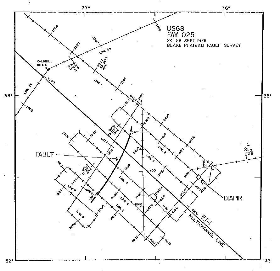
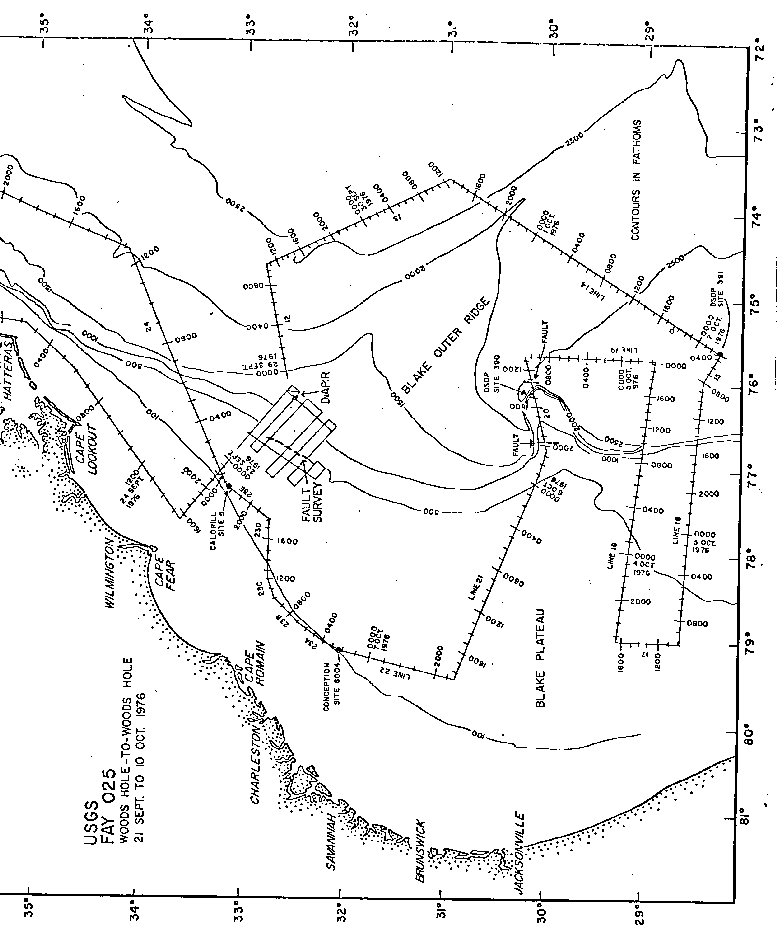
After departing the buoy site the FAY continued south at full speed along CDP line #12 until past Cape Hatteras and just north of Cape Fear. At 1530Z/24 September, the R/V FAY turned southeast, slowed and deployed the airgun, minisparker and magnetometer systems. Line #1 ( Figure 2 and Figure 3) led across the Blake Plateau into the area for the fault survey. That survey continued until 2112Z/ 28 September during which time lines # 1 through 11 were completed. The fault was found to be 40 to 50 km long and trend at about N25dE, A diapir structure was also found at the southeast end of the fault survey ( Figure 2 and Figure 3).
Line 12 was run to the northeast in order to tie into previous lines from FAY 019, Lines 13 and 14 ( Figure 2) crossed the Blake Outer Ridge and continued south to D.S.D.P. Site #391. Excellent quality records all the way down to basement were obtained along the entire line.
After crossing D.S.D.P. site #391 at 0407/2 October 1976 the FAY headed west to.begin a series of east-west lines (#15 to 21, Figure 2). Line #20 crossed deep-sea drilling site #390 and then detected a major fault with several hundred meters of offset at the western edge of the Blake Spur.
Between 0170Z/7 October and 0030Z/8 October the FAY ran a line primarily for minisparker data between GLOMAR COnception drill site 6004 and a Caldril site 5 east of Cape Fear.
After that the FAY pulled all streamers and headed toward Woods Hole along C.D.P. line #13.
The FAY reentered Woods Hole at 7:30 A.M., E.D.T. (1130Z) on Sunday, October 10, 1976 to complete FAY cruise 025.
Throughout this entire cruise the weater was perfect. Winds hardly ever exceeded 15 knots and seas never exceeded three feet.
The performance of the scientific staff and equipment was excellent.
The cooperation of Captain Peter Olander, Chief Engineer, Larry Weeks, and the crew of the R/V FAY was outstanding and contributed greatly to the success of the voyage.
A. Fault Survey The fault which had been detected on C.D.P. line #BT-1 was found to terminate between 10 and 20 km north and between 30 to 40 km southwest of BT-1. It's trend is N25dE and the maximum offset appears to be about 100 m at a subbottom depth of 1 km but decreasing to 5 m or less in the upper 100 m of the section. A few smaller faults with offsets of 10 to 20 m may exist but they are not continous between the grid lines (6 mile spacing).
The fault occurs at the edge of the Blake Plateau where the Northwest end of the Blake Outer Ridge meets the plateau. The Blake Outer Ridge has been shown to be a sedimentary structure which has built rapidly during the Tertiary period (post-Horizon A). The fault is likely to be a result of isostatic loading of the oceanic crust with the large weight of sediments contained in the Blake Outer Ridge.
B. Diapir During the fault survey a diapir which comes from beneath Horizon A and pushes up surface sediments was found at 32d30.3'N and 76d11.6'W. No magnetic or gravity anomaly is associated with the structure, It is probably composed of either salt or shale.
C. Profile over Blake Outer Ridge to D.S.D.P. Site #391 Although good penetration to basement was achieved along this entire line, the continuity of horizons A,A* and B was not necessarily clear. A careful analysis of the line will be necessary to establish it all horizons can be traced from D.S.D.P. site #391. Horizon B was not a prominent reflector on our record at site #391, but still could be traced to north of the Blake Outer Ridge.
D. Blake Spur Faults On line #20, two apparent faults were detected, one at the base of the escarpment and one near the western edge of the Spur. Several hundred meters of displacement has occurred. Since shallow water reefal material of Neocomian Age (118 m.y.) was drilled at 2.9 km depth at D.S.D.P. Site #390, the fault appears to have been related to the subsidence of the Spur,
E. Westward Dipping Horizons Beneath Blake Plateau Lines 16, 18 and 21 show that horizons dip gently toward the west, The Tertiary section on the Blake Plateau is thought to be less than 500 meters and therefore these westward dipping beds must be Cretaceous in age. This contrasts with the generally seaward dipping trend seen north of Cape Hatteras. Lines 16 and 18 also show these westward dipping beds coming into a broad gentle arch which lies at the outer edge of the Plateau.