Open-File Report 1998–0297
Science for Watershed Decisions on Abandoned Mine Lands: Review of Preliminary Results, Denver, Colorado, February 4-5, 1998
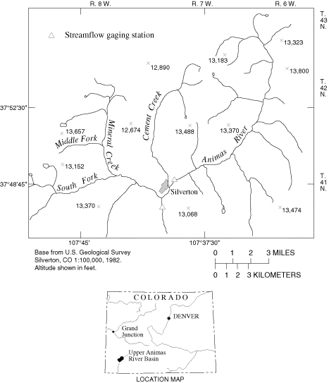
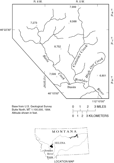
The upper Animas River and the Boulder River watersheds have been identified as the priority watersheds in their states for remediation of contamination associated with AML. The upper Animas River watershed, located near Silverton in southwestern Colorado (Fig. 1), was selected in March 1996 using a prioritization process that considered the available data, ongoing activities, and water-quality impairment from abandoned mines. The Boulder River watershed, located near the town of Basin in western Montana, about 25 miles south of Helena (Fig. 2), was chosen in May 1996 from five candidate watersheds based on an analysis of geologic factors, metal loading, the status of ongoing remediation activities, general knowledge of the candidate watersheds, and extent of Federal land.

Figure 1. Location of the upper Animas River watershed, southwestern
Colorado. [Return to text above.textplace1]
Although the geographic, socioeconomic, and geologic characteristics of each watershed have similarities, the differences are significant (Table 1). Both watersheds are in mountainous terrain with abundant snowfall, but elevation and annual precipitation are less in the Boulder River watershed. The upper Animas River watershed is only somewhat larger than the Boulder River watershed, but their shape, relief, and drainage patterns are different. In Colorado, the study area consists of the entire Animas River watershed upstream of Silverton. In contrast, the Montana study site encompasses three adjacent Boulder River tributaries (Basin, Cataract, and High Ore Creeks) and a short reach of the Boulder River downstream of the tributary confluences. Both areas have a history of metal mining dating back to the late 1800s. Most mining activity ceased by the 1940s, although some activity occurred as recently as the 1990s. Principal metals produced from both watersheds included gold (Au), silver (Ag), lead (Pb), and zinc (Zn). Ore bodies are sulfidic, and acid mine drainage occurs in both areas. The number of abandoned mines is an order of magnitude higher in the upper Animas River watershed than in the Boulder River watershed. Much of the mining in both study areas occurred on privately-owned (patented) mining claims. However, some mine, mill, and smelter sites; and tailings deposits, along with eroded tailings distributed along various reaches of stream channels and flood plains, are located on Federal land.
Although populations in both areas vary seasonally as tourists and temporary residents move into the watersheds during the summer, the population of the upper Animas River watershed is much greater than that of the Boulder River study area. In the upper Animas River watershed, tourism, in part based on historic mining, is an important industry. Residents of the Boulder River study area are engaged primarily in mining, logging, or agricultural activities.
| Watershed Characteristics | Upper Animas River, Colorado | Boulder River, Montana |
|---|---|---|
| Geography | ||
| Drainage area (mi2) | 150 | 90 |
| Precipitation (in/yr) | 40-50 | 14-30 |
| Snowfall | high | high |
| Elevation (ft) | 9,200-13,800 | 4,900-8,800 |
| Primary fish species | brook trout | rainbow trout |
| Socioeconomics | ||
| Population | 500-3,500 | 100-200 |
| Major Industries | tourism | logging, mining, cattle |
| Public intrest in AML | ||
| -within watershed | high | moderate |
| -state wide | high | high |
| FLMA | USFS, BLM | USFS, BLM |
| Reclamation sponsorship | Stake holders | State |
| Resources | ||
| General geology | Intercaldera lavas (hydrothermally altered) | Granitic batholith (veins) |
| Metals mined | Ag, Au, Pb, Zn | Ag, Cu, Pb, Zn, Au |
| Major mining period | 1880-1990 | 1870-1940 |
| Carbonates | some | some |
| Abandoned mines | 1,500 | 150 |
| AML characterization | high | low |
| Fisheries impact | significant | limited |
The primary effect of mining in both watersheds is degraded water quality and aquatic habitat, which consequently affects aquatic and fishery resources. Some streams are devoid of fish, and many others may have impaired fisheries. Abandoned mines affect streams through direct discharge of acid drainage from adits, seepage from tailings piles, and erosion of tailings by storm runoff or streambank erosion. The extent of subsurface contaminant movement in both study areas is virtually unknown. The known extent of mining impact on surface waters in the Colorado area has been documented downstream to Durango and to the confluence with the San Juan River. Many of the AML sites that appear to have a serious effect on surface-water quality and local fisheries in the Boulder River watershed have been inventoried for the Federal land-management agencies by the State of Montana. These inventories included some data on water quality and chemistry of tailings and have been used to target AML sites that are likely candidates for remedial activities. In recent years, Montana has been active in remediating portions of the Comet mine on privately owned land in the upper reaches of High Ore Creek basin (Fig. 2).

Figure 2. Location of the Boulder River watershed, southwestern
Montana. [Return to text above.textplace2]
Commensurate with the greater impact and higher population, the upper Animas River watershed has a substantially greater amount of natural resource information and AML characterization completed to date. The Animas River Stakeholders Group (ARSG) has taken an active role in the characterization and remediation of the watershed. The ARSG represents private, local, State, and Federal entities. In contrast to the Boulder River area, where AML remediation is only beginning to be an important issue, active public involvement and interagency cooperation in addressing AML remediation has a long history in the upper Animas River watershed.
1U.S.Geological Survey, 764 Horizon Drive, Grand Junction, CO 80506 (pbvongue@usgs.gov)
2U.S. Geological Survey, Drawer 10076, Federal Building, Helena, MT 59626 (dnimick@usgs.gov)
OFR 98-297 Home | OFR 98-297 Table of Contents | Previous | Next