|
|
PLAN
VIEW |
PERSPECTIVE
VIEW |
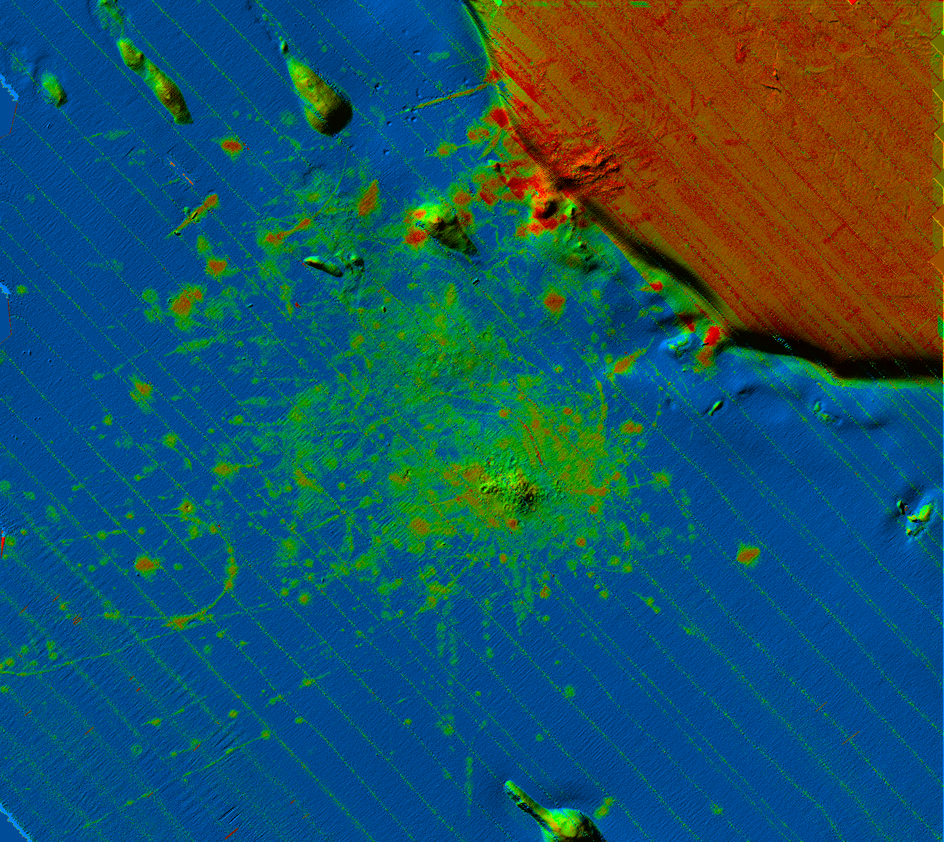
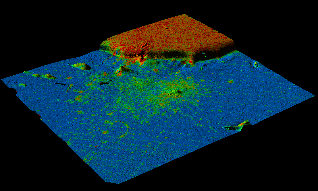
Massachusetts Bay Disposal Site Plan View and 3-D Perspective View Maps
|
|
PLAN
VIEW |
PERSPECTIVE
VIEW |
Low
High
![]()
Mud
Sand
Gravel
Backscatter Intensity
These are composite images in which backscatter and sun-illuminated images have been combined to show the composition of the sea bed and the topographic relief. Sun-illumination is from the north. Blue represents low backscatter mud of Stellwagen Basin, and orange represents high backscatter gravelly sand and cobbles and boulders of Stellwagen Bank. Green represents moderate backscatter deposits of dredged material. The green mound in the middle of the image is located at the present disposal point. Red represents very high backscatter deposits of rock debris from the excavation of the Ted Williams Tunnel beneath Boston Harbor. Click on the individual images to view them close-up.
Click here to view an animated flyover of the disposal site.
BRIEF HISTORY OF THE DISPOSAL SITE REGION
Since at least the 1940's, a region in the northern part of Stellwagen Basin has been used as a repository for dredged material, rock debris, sunken vessels, munitions, construction debris, and industrial and low-level radioactive waste. Hazardous materials have not been disposed there in recent years. The disposal region lies 17 nautical miles (nm) east of the entrance to Boston Harbor and is adjacent to the western boundary of the Stellwagen Bank National Marine Sanctuary (NMS) established in 1992 (see location map). Disposal has occurred in several areas of this region (U.S. Environmental Protection Agency and U.S. Army Corps of Engineers, 1989; U.S. Environmental Protection Agency, 1992; U.S. Congress, 1993a,b). In the 1963-1975 period, the U.S. Coast Guard maintained a disposal point marked by the "A" buoy (42o 26.8'N, 70o 35.0'W) in the northern part of the region shown here that was known as the Industrial Waste Site (IWS). In 1975, the "A" buoy was moved 1.1 nm to the south (42o 25.7'N, 70o 35.0'W) to mark the center of a disposal site also known as the Industrial Waste Site. Two years later, in 1977, this second IWS was replaced by a new disposal site (designated for dredged material only) called the "interim" Massachusetts Bay Disposal Site (iMBDS; center at 42o 25.7N, 70o 34.0W ). The iMBDS was established less than one nm to the east of the second IWS. Finally, in 1993 the iMBDS was replaced by the present site for dredged material known as the Massachusetts Bay Disposal Site (MBDS; center at 42o 25.1'N, 70o 35.0'W). It is located southwest of the iMBDS. The MBDS was established so that the disposal site would lie outside the western boundary of the newly designated Stellwagen Bank NMS. The MBDS and the sanctuary boundary are shown on the accompanying seabed topographic and backscatter images and on the interpretive map. The history of disposal since 1975 is complicated by the fact that a disposal "site" (a circular area 2 nm in diameter) has been established at 3 locations while a disposal "point" (marked by a buoy) has been established at 2 locations. In addition, the disposal point has not been located at the center of the disposal site since 1977. All three disposal sites established since 1975 (second IWS, iMBDS, MBDS) are identical in size and overlap each other to some extent, as shown on NOS Chart 13267 (National Oceanic and Atmospheric Administration, 1994). From 1975 to 1985, the "A" buoy (42o 25.7'N, 70o 35.0'W) marked the disposal point in both the second IWS and the iMBDS. From 1985 to the present, the "FDA" (or "MDA") buoy (approximately 42o 25.1'N, 70o 34.45'W) has marked the disposal point for dredged material in both the iMBDS and the MBDS. Most disposal since 1963 has occurred at buoyed points in water depths of 85 to 90 meters in Stellwagen Basin. However, from June, 1992 to October, 1993 disposal of fresh blasted rock debris (from an excavation in Boston Harbor) was permitted in the iMBDS at an unbuoyed point (42o 26.5'N, 70o 34.0'W) on the edge of Stellwagen Bank at 50 m water depth.
[an error occurred while processing this directive]