Mineral Resources Section
Indiana Geological Survey
611 North Walnut Grove
Bloomington, IN 47405-2208
Telephone: (812) 855-2687
Fax: (812) 855-2862
e-mail: whasenmu@pyrite.igs.indiana.edu
The rapid development of computer hardware and software in recent years is changing the way geologists work. Geologists are rapidly discovering new ways to solve complex geologic problems and produce specialized products that better meet society's needs, as inexpensive and powerful computer hardware and software become increasingly commonplace. Mapping, a basic geologic tool, is no exception. Geologists are rapidly abandoning traditional mapping techniques in favor of digital techniques. The digital mapping techniques described herein work well when applied to the thin, gently dipping sedimentary rocks that typify Indiana's bedrock geology. Geologists mapping in similar geologic settings should be able to realize the same advantages using these techniques. Geologists mapping stratiform rocks that dip at steep angles should note that the techniques described herein presume that the mapped strata are nearly horizontal so stratigraphic thickness, which is measured normal to bedding, is regarded as equal to vertical thickness here. Geologists mapping igneous intrusions and metamorphic rocks or highly deformed sedimentary rocks where geologic contacts may overlap themselves will not be able to apply these techniques.
The Mineral Resources Section of the Indiana Geological Survey (IGS) is committed to making its data and interpretations available to industry, government, academia, and the general public and sees the abundance of sophisticated computer hardware and software now on the market as an obvious opportunity to better fulfill this commitment. The Mineral Resources Section has successfully completed a pilot project to test the feasibility of constructing geologic maps with a computer contouring program (Surfer 4.0 and 5.03). The pilot study-- an assessment of the mineral resources in Putnam County, Indiana-- used ordinary PC-computers and inexpensive software to economically create, modify, and update maps showing mineral resources and statistical summaries of the resource characteristics. The maps, created with the contouring program, can be exported to the IGS's geographic information system (GIS) (Arc/Info) for GIS applications.
The digital mapping technique described here is unique in that the digital geologic maps are computer-generated interpretations of geological observations stored in a database and are not digitized or scanned/vectorized versions of hand-drawn maps. The advantages of this technique are obvious: it eliminates the necessity of creating hand-drawn maps; the geologic observations and interpretations that underlie any part of any derivative map are easily located in the database; there are never discrepancies between the mapped extent, structure, and shape of a subcropping surface; and a second geologist using the same database and contouring procedures will obtain the same results.
The mapping techniques described here were developed and tested in an IGS-funded study of the mineral resources in Putnam County, Indiana. Putnam County is located about midway between Indianapolis and Terre Haute, and lies on the northeast flank of the Illinois Basin. Putnam County was selected for the pilot study because 1) it is a focus of mineral resource mining and exploration in Indiana; 2) the Mineral Resources Section of the IGS has access to abundant and varied data relating to the mineral resources of Putnam County; and 3) the geology of Putnam County is sufficiently complex to provide a challenging test of the database design and digital mapping techniques.
The pilot study has been completed and the Mineral Resources Section plans to proceed by proposing the development of mineral resource databases, computer-generated maps of mineral resource-bearing sedimentary rock units, computations of resource quantity and quality, and development of mineral resource GIS coverages for selected Indiana 1:100,000 scale quadrangles.
The computer mapping in Putnam County was based on a database developed from public domain geologic data stored in IGS files and at other public agencies. Data sources included the field notes and work maps of IGS geologists, published maps and reports, measured sections, descriptions of exposures in active and abandoned quarries, core descriptions, water well records, soils maps, petroleum exploration well records, and IGS seismic refraction records. Most of the outcrop and subsurface data sites include at least one direct observation of the spatial location of a stratigraphic boundary. Some sites record only indirect evidence such as isolated outcrops, float, or slope breaks. Indirect evidence was included in the database because it helps to establish the presence of a mappable unit at a spatial coordinate. The Putnam County Mineral Resource Database, used to map every mineral resource-bearing rock unit from the surface down to the Rockford Limestone (Mississippian), contains geologic data pertaining to 5,582 locations in and near Putnam County, 20,080 records of stratigraphic units found at those sites, and 20,333 descriptions of the lithologic constituents in those stratigraphic units.
The task of interpreting and computer-mapping sedimentary rock units with public domain data is complicated by variations in spatial and stratigraphic precision. Spatial imprecision occurs where location descriptions--especially vertical control-- are vague. Stratigraphic imprecision occurs where the description of a stratigraphic sequence contains inadequate subdivision and lithologic characterization. These two kinds of imprecision often occur independently. A driller's log, for example, may record a very precise spatial location for a vague and generalized description of a rock sequence. On the other hand, a detailed measured section recorded somewhere in a quarry may lack adequate spatial control. Either kind of data imprecision limits the precision of computer-mapping regardless of data density.
The Putnam County Mineral Resources Database is a relational database (Paradox 5.0) comprising three principal tables: the Location, Stratigraphy and Lithology Tables (Figure 1). Other tables in the database perform housekeeping functions such as value checking and storing special data.
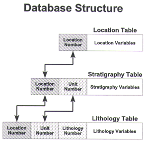
Figure 1. Structure of the Putnam County Mineral Resources Database. |
The Location Table is the fundamental table in the database. Each record in this database table documents a location where geospatial data was recorded. Variables assign a unique location number, identify the data (source, type, etc.), contain descriptions of geographic location (township, range, section, quadrangle, etc.), and store a state plane coordinate for each data site.
Each record in the Stratigraphy Table documents a stratigraphic unit recorded at a data site. Figure 2 illustrates how stratigraphic unit numbers differentiate multiple units recorded at the same site. Variables in the Stratigraphy Table record the elevation of a unit's upper and lower boundary, allow the geologist to assign stratigraphic names and confidence levels to a unit and its upper and lower boundaries, and provide space to record sample information. Figure 2 illustrates how units in a hypothetical measured section would correspond with records in the Stratigraphy Table and how a conformable contact (Paoli Limestone/Bethel Formation) and an unconformable contact (Bethel Formation/Mansfield Formation) are entered in the Stratigraphy Table. Stratigraphic boundary positions are converted to elevations to make subsurface data, which reads from the surface downward, compatible with measured sections, which record unit thickness from the base of a section upward. Unit thickness is not stored in the database because the thickness of any interval can be computed by subtracting the appropriate upper and lower boundaries.
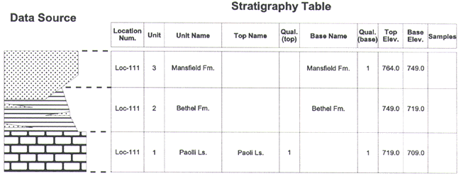
Figure 2. Relationship between stratigraphic units in a geologic record and the Stratigraphy Table. |
The Lithology Table stores information about the lithologic composition of stratigraphic units. Each record in this database table documents a lithologic description applied to a unit recorded in the Stratigraphy Table. Lithology numbers are assigned to each lithology to differentiate lithologic descriptions. Unit 99 in the hypothetical core description illustrated in Figure 3, for example, consists of two interbedded lithologies-- sandstone and shale. The Lithology Table contains separate records for each of these lithologies.
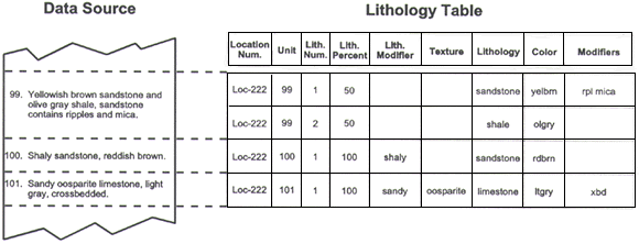
Figure 3. Relationship between lithologic descriptions in a geologic record and the Lithology Table. |
Lithologic terminology from field notes, measured sections, core descriptions, drillers' logs, and water wells is entered directly into the database or with minor editorial changes. Variations in the detail of lithologic descriptions from different sources are handled by routing the descriptive terminology into three rock classification variables. Every lithologic description, from the simplest to the most detailed, includes an entry in the lithology variable. This variable stores rock names such as "limestone," "shale," or "sandstone," and non-lithologic terms such as "covered" or "core loss." More detailed rock descriptions, like the hypothetical core description illustrated in Figure 3, include terms like "shaly" or "calcareous" that modify the rock name. Unit 100 in Figure 3 illustrates how a lithologic modifier is handled in the database. The combination of common lithologic terms stored in the lithology variable and lithologic modifier variable designate approximate positions in a rock classification tetrahedron similar to the classification of mixed carbonate and siliciclastic sediments proposed by J. Mount (1985, p. 438) so this pair of variables is especially useful for characterizing the lithology of mapped units. The texture variable stores the petrographic terminology included in the most detailed lithologic descriptions. Unit 101 in Figure 3 illustrates how a petrographic term like "oosparite" is entered into the Lithology Table without usurping space reserved for simple rock names and lithologic modifiers. The color variable stores an abbreviated rock color term and the modifiers variable stores all other descriptive terms as space delimited abbreviations. Abbreviations used in the database are from Swanson (1981). The "ripples" and "mica" noted in the description of unit 99 in Figure 3 illustrate how abbreviations of descriptive terms are stored in the modifiers variable. Units that have a specific characteristic, such as "ripples" or "mica," or "brachiopods" are located by initiating a string search in the modifiers variable of the Lithology Table.
This simple database table structure accommodates variations in terminology and level of detail found in public domain rock descriptions and classifies the data so it is possible to retrieve simple or detailed lithologic summaries of mapped rock units and investigate composition trends.
Geologists make geologic maps by collecting data, interpreting those data, and then drawing a geologic map that fits the data and expresses the interpretation. A geologist making a geologic map with a contouring program collects data (in a database), interprets those data, and creates grid files with the contouring program which are models of the surfaces that bound mappable geologic units. Bounding surfaces are modeled by selecting contouring algorithms, adjusting parameters within the algorithms, combining surfaces, and when necessary adding interpretive data to force the surface to comply with a geologic interpretation. Utilities in the contouring program allow the geologist to derive geologic maps by combining, intersecting, and contouring the gridded models of bounding surfaces.
Conformable contacts are relatively simple surfaces and can be gridded directly when control points are well distributed throughout the map area. Control points for most of the conformable contacts in Putnam County, however, tend to be clustered in the outcrop belt and shallow subsurface making it necessary to extrapolate these surfaces to the edges of the map area. Conformable contacts in Putnam County were extrapolated by retrieving data documenting the interval between the contact and a stratigraphically lower marker surface and extrapolating the isopach of this interval to the edges of the map area. Adding the isopach of the interval to structure on the stratigraphically lower marker surface yields a structure surface which conforms to the data and extrapolates the surface to the edges of the map.
The spatial and stratigraphic noise that affects the vertical positions of boundary surfaces is approximately equal in magnitude to the amplitude of small-scale folding and faulting in Putnam County. Smoothing (matrix smoothing or cubic spline grid extensions) that successfully damps this noise also eliminates the small-scale structural features. The selection of a final map scale for the Putnam County (1:250,000) reflects this limit in the data quality and consequent map detail.
Either the upper or lower bounding surface of a sedimentary rock unit may be complex due to the combined effects of outcrop, subcrop, and depositional irregularity. Such is the case in Putnam County where Mississippian resource-bearing rock units outcrop on the topographic surface, subcrop on the bedrock surface, subcrop on the sub-Pennsylvanian unconformity, and exhibit considerable depositional thickening and thinning.
Building gridded models of complex erosional surfaces generally requires several steps. The gridded model of the sub-Pennsylvanian unconformity in Putnam County, for example, was created by combining modeling that focuses on the trend of the unconformity's upland surface with modeling that focuses on the thalwegs and shape of the southwestward-trending erosional valleys in the unconformity surface.
Deriving a geologic contact from grid file models of bounding surfaces is a simple task with a contouring program. A geologic contact is the intersection between a bounding surface of a rock unit and a truncating surface such as the bedrock surface or an unconformity. A geologic contact line is derived by using grid math (a Surfer utility for defining a functional relationship between two grids with the same dimensions) to compute the difference between the elevation of the truncating surface and the bounding surface of the rock unit. The zero contour on the resultant grid is the contact line.
The thickness of a mapped rock unit is derived by using grid math to compute the difference between the composite upper bounding surface and the composite lower bounding surface of the unit within the mapped extent of the unit. In Putnam County the thickness of every mineral-resource-bearing Mississippian unit is a combination of the isopach thickness of the unit and the erosional effects of the topographic surface, the bedrock surface, and sub-Pennsylvanian unconformity.
The overburden on a mapped rock unit is derived by using grid math to compute the difference between the topographic surface and the upper bounding surface of the rock unit within the mapped extent of the rock unit.
The Mineral Resources Section plans to continue the development of mineral resource databases, construction of computer-generated geologic maps, and mineral resource assessments. Experience gained through the Putnam County pilot study combined with an assessment of the quantity and quality of public domain data indicate that it would be practicable and cost effective to compile mineral resource data at a scale of 1:24,000 and construct computer-generated geologic maps at a scale of 1:100,000 using U.S. Geological Survey 30 X 60 minute quadrangles as the mapping base provided accurate digital elevation models (DEM's) with grid densities of approximately 200 ft or less are available. Each project proposal will include a request for modest external funding and support to supplement IGS resources. In return the IGS will deliver mineral resources databases, computer-generated resource maps, reports summarizing mineral resources, and GIS coverages of resources.
Mount, Jeffrey, 1985, Mixed siliciclastic and carbonate sediments: A proposed first-order textural and compositional classification: Sedimentology, v. 32, p. 435-442.
Swanson, R. G., 1981, Sample examination manual: American Association of Petroleum Geologists, Methods in Exploration Series, 31p., 4 Appendices, 21 Charts.
U.S.Department of the Interior, U.S. Geological Survey
<https://pubs.usgs.gov/openfile/of98-487/hasen.html>
Maintained by Dave Soller
Last updated 10.06.98