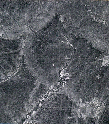
Figure 1. Portion of a Landsat 1 MSS satellite image acquired over east-central Illinois on June 11, 1978. The city of Champaign-Urbana is at lower right of image. The arcuate, lighter toned patterns evident on this image denote the positions of end moraines. This graphic portrayal of glacial features is unusual on such imagery in an area dominated by agricultural land use, and the image acquisition coincides with optimal drainage conditions and early crop stage. |
RETURN TO Remote Sensing Inputs to a Geologic Mapping Program for Illinois
U.S.Department of the Interior, U.S. Geological Survey
<https://pubs.usgs.gov/openfile/of98-487/luman1.html>
Maintained by Dave Soller
Last updated 10.06.98