Illinois State Geological Survey
615 East Peabody Drive
Champaign, IL 61820
Telephone: (217) 244-2179
Fax: (217) 333-2830
e-mail: dluman@geoserv.isgs.uiuc.edu
Geologists use a variety of map data sources to assist in interpreting surficial characteristics; and while maps expressly provide several types of information, they are, nevertheless, abstractions and represent the physical landscape in a generalized manner. In contrast, image-based data are a singularly unique information source that provide an ungeneralized portrayal of landscapes, and the usefulness of aerial image interpretation for mapping geologic features has been long recognized (Watson and Knepper, eds., 1994).
In Illinois, agricultural lands account for three-fourths of the surface area of the state (Illinois Department of Natural Resources, 1996) and surficial geologic features are obscured during much of the year. However, during the late winter and early spring period, and under optimum drainage conditions, remote sensing imagery can detect subtle changes in the uppermost few feet of geologic materials that are directly related to surficial processes.
Earth resources-based remote sensing began over twenty-five years ago with the commissioning of the Landsat 1 satellite in June, 1972. Since then, there have been significant improvements in sensors, especially with regards to the spatial and spectral resolution available from an increasing number of satellite-based systems. For comparison, in 1972 Landsat 1 was capable of resolving a ground area of approximately 79 x 79 meters (0.58 hectare or 1.4 acres); in 1996, the Indian Remote Sensing (IRS-1C) satellite was successfully launched with a panchromatic sensor that resolves a ground area of 5.8 x 5.8 meters (0.003 hectare or 0.01 acre). This represents more than a 185x improvement in the discrimination of areal features. During the same period, the spectral resolution of sensors has improved from a restriction to the optical wavelengths (0.38-1.3 micrometers; e.g., visible and near infrared) to including the middle infrared and microwave regions of the electromagnetic spectrum.
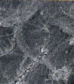
In terms of geology, satellite-based imagery have been proven to be of value in the mapping of major features such as folds, faults, intrusions, volcanic flows, discrimination of differing lithologies, and the analysis of dynamic surface processes. Satellite imagery have been especially effective in inaccessible or remote geographic regions for which little or no good-quality maps were available (Szekielda, 1988). In Illinois, there has been only limited use of satellite imagery for geological mapping due to a combination of factors including, a) predominance of agricultural land use obscuring surface features; b) prevalence of extensive, and in many locations, thick glacial deposits; c) spatial resolution considerations, and d) availability and cost of imagery. Despite these factors, carefully selected satellite imagery can provide dramatic portrayals of regional-scale, surficial geologic conditions that prevail in Midwestern glaciated landscapes (Figure 1).
Click on thumbnail for full-scale image [106K] |
Figure 1. Portion of a Landsat 1 MSS satellite image acquired over east-central Illinois on June 11, 1978. The city of Champaign-Urbana is at lower right of image. The arcuate, lighter toned patterns evident on this image denote the positions of end moraines. This graphic portrayal of glacial features is unusual on such imagery in an area dominated by agricultural land use, and the image acquisition coincides with optimal drainage conditions and early crop stage. |
Developments in airborne remote sensor systems have also been significant during the past twenty-five years, and applications using airborne systems are proliferating in natural resource sciences. However, the availability and cost of digital airborne imagery remain as limiting factors to the more widespread use of such information for large-scale geological mapping (e.g., 1"=2000' and larger). Kramer (1994) provides an excellent review, although somewhat dated, of satellite and airborne remote sensor systems.
One cost-effective source of digital imagery is the U.S. Geological Survey's Digital Orthophoto Quadrangle (DOQ) product. Currently, 72 percent of the area of the conterminous United States is either contracted or already available, and the USGS is progressing towards its goal of complete nationwide coverage by 2002. DOQs are coincident with the USGS 7.5-minute quadrangle map coverage, have been geometrically corrected to conform to a standard cartographic map projection, and possess a 1x1 meter ground spatial resolution (USGS, 1991). Black-and-white (B&W) or color infrared (CIR),1:40,000 (nominal) scale, National Aerial Photography Program (NAPP) and NAPP-like aerial photography are the primary imagery sources used in the production of DOQs. Approximately 10 percent of the DOQs currently available or in production are being developed from CIR source aerial photography, with the remaining 90 percent using B&W source aerial photography.
Orthophotography combines the image characteristics of an aerial photograph with the geometric qualities of a map. Unlike a typical aerial photograph, distortions due to relief displacement (hills, stream valleys, buildings, etc.), camera lens, and aircraft attitude have been removed so that all ground features are shown in their correct ground positions. This makes possible a true image map, permitting direct measurement of distance, areas, angles, and detailed positions of ground features, many of which may be omitted or generalized on traditional maps. In a digital format, orthophotography can fulfill a fundamental role as a planimetrically accurate base map onto which additional spatial information can be readily incorporated using a geographic information system (GIS).
Produced from recent NAPP aerial photography, USGS DOQs are also frequently a more up-to-date representation of cultural and physical features than the published USGS 7.5-minute quadrangle map, especially within geographic areas that are experiencing rapid urbanization or extractive activities. For example, in Illinois 42 percent of the state's USGS 7.5-minute quadrangle maps possess publication dates that are more than 20 years old (Table 1). In contrast, Illinois' NAPP 2 aerial photography was acquired in 1993-1995, and at the date of this writing, approximately 75 percent of Illinois' 1998 NAPP 3 aerial photography has been collected. While the prioritization and funding for the update and revision of Illinois' USGS 7.5-minute quadrangle base data will continue to be a problematic issue for many years, the use of DOQs as a surrogate for up-to-date base maps is an affordable alternative available to many states, especially given the federal cost-sharing incentives available for statewide DOQ production.
Table 1. Status of USGS 7.5-minute quadrangle maps for Illinois
| Publication date | Number of quads | Percentage |
| 1987-1997 | 205 | 19 |
| 1977-1986 | 421 | 39 |
| 1967-1976 | 256 | 24 |
| 1957-1966 | 160 | 15 |
| 1947-1956 | 29 | 3 |
| Totals | 1,071 | 100 |
Although black-and-white aerial photography has long been used as the standard for geologic interpretation, most applications are improved using color and CIR aerial photography. This is because the human eye can discriminate many more shades of color than gray tones, and the interpretation of color on standard color aerial photography more closely mimics human experience in everyday interpretation of the environment. While standard color aerial photography records the "visible" portion of electromagnetic energy, the same reflected radiation that the human eye can sense, CIR aerial photography extends the range of sensitivity into the "invisible", reflected near infrared. What this means is that the discrimination of many landscape features is enhanced using CIR photography, including such phenomena as:
In 1996, the Illinois State Geological Survey (ISGS) began an initiative referred to as the Illinois Geologic Mapping Program (IGMaP), an extension of the existing large-scale geologic mapping program. One of the primary objectives of IGMaP is to derive GIS-based maps and ancillary data for a wide variety of geologic factors for each of the state's 1,071 USGS 7.5-minute quadrangles by the year 2025. The USGS 7.5-minute Villa Grove, IL and Vincennes, IN-IL Quadrangles were selected for the original IGMaP pilot project. As one of the IGMaP base data components, DOQs were produced for these two quadrangle areas based upon 1988 NAPP 1 CIR aerial photography. As additional 7.5-minute quadrangle areas have been added to IGMaP, image base maps are being developed from already existing B&W DOQs, and the production of CIR-based DOQs for the same areas was not deemed necessary.
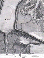
Because of their high level of feature detail, DOQ-based reconnaissance maps produced at scales of 1"=1000' and 1"=500' (RF 1:12,000 and 1:6,000, respectively) are being used effectively for conducting tasks such as well verification, documenting outcrop locations, guiding field traverses, and as an interpretive base for surficial geologic mapping. When selected USGS Digital Line Graph (DLG) feature data are incorporated with DOQs, such reconnaissance maps provide an excellent base for geologic mapping (Figure 2). ISGS field geologists are adopting this new form of base map as an additional, and sometimes a replacement to the published USGS 7.5-minute topographic quadrangle map.
Click on thumbnail for full-scale image [266K] |
Figure 2. Portion of a 1" = 500' scale base map used for reconnaissance geologic mapping, developed from the USGS Digital Orthophoto Quadrangle and Digital Line Graph data for the 7.5 minute Fishhook, Illinois Quadrangle. Unverified well locations from the ISGS are also shown. |
An informal experiment was conducted by ISGS scientists to ascertain the relative usefulness and accuracy of digital map and image base products for large-scale geologic mapping. The principal source materials included the Digital Raster Graphic (DRG), DLG Hydrography and Hypsography, and DOQ for a portion of the USGS 7.5-minute Kellerville, IL Quadrangle. The source information used to produce the DRG was the published Kellerville, IL Quadrangle (1981 publication date; source aerial photography dated 1974). The same published quadrangle was used to compile the USGS DLG category data. Lastly, the DOQ was developed from B&W NAPP 2 aerial photography acquired in March, 1994.
All of the key bedrock outcrop locations within the study area were described and located in the field using a reconnaissance map similar to that shown in Figure 2. In addition, an accurate location was determined for each described outcrop using global positioning systems technology (GPS). Subsequent to the field mapping, the Pennsylvanian bedrock surface was interpreted and delineated on the DRG in a "heads-up" digitizing approach using ArcView (Figure 3A). This trace was then transferred directly to the DOQ image base containing the GPS-based outcrop locations (Figure 3B). The DRG was preferred by the mapping geologist because of its significantly smaller file size as compared to the DOQ, requiring only modest computer resources. USGS 7.5-minute DRGs typically range from approximately 3 to 30 megabytes in size (dependent upon pattern density) as compared to approximately 165 megabytes for a single channel, B&W DOQ and approximately 500 megabytes for a three channel, CIR DOQ.
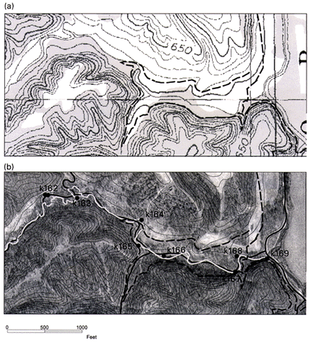
Figure 3. (A) Portion of the 7.5-minute USGS Digital Raster Graphic for the Kellerville, Illinois Quadrangle used as a preliminary base map for delineating surface geology. Trace of the Pennsylvanian contact shown as bold, dashed line. (B) Portion of the USGS Digital Orthophoto Quadrangle (DOQ) and 7.5-minute Digital Line Graph Hypsography and Hydrography (bold solid line) for the same geographic area as shown above. White line represents the current hydrography delineated using the DOQ. Points define Pennsylvanian bedrock exposure locations as determined from field-based GPS survey. Discussion in text. |
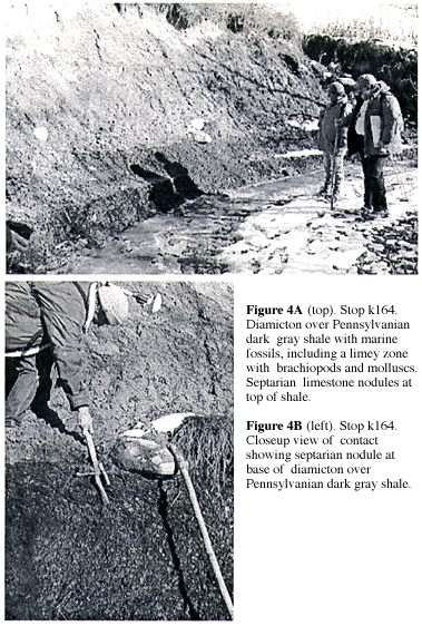
It was discovered that positional errors occurred in transferring the field information to the DRG. This can be explained in part due to the lack of feature detail inherent in the DRG as compared to the DOQ. However, a more important factor is the 20-year difference in the source materials used for the DRG and DOQ. Not only are there noticeable differences in the generalization of the stream course as seen on the DRG and DLG Hydrography as compared to the DOQ (compare Figures 3A and 3B), but changes in the position of the thalweg of the stream have also occurred. The largest positional errors occur at the GPS outcrop locations k164 and k168 (Figures 4 and 5), where discrepancies between DRG/DLG and DOQ hydrography delineation are evident. Since Quaternary exposure and bedrock outcrop locations are typically referenced to identifiable map features in rural areas such as stream meanders, prominent slope segments, etc., it is not surprising that such positional errors can occur when using outdated base maps.
|
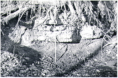
Figure 5. Stop k168. Colchester Coal, 1.3 ft. thick, overlain by 1.3 ft. of black Mecca Quarry Shale. |
The measured positional error is approximately 50 feet, which is not discernable on a 1:24,000-scale topographic quadrangle map. However, at larger scales such as 1"=500', the error averages 0.1 inch, and therefore is of concern when producing geological maps at larger publication scales. The potential for error can therefore be minimized by ensuring that published quadrangle maps being used as the primary base for geological mapping are updated and revised using more recent NAPP source material to reflect current landscape features. If this is cost-prohibitive, an affordable alternative is to use the DOQ for the primary feature interpretation.
Since CIR aerial photography was used for the production of the DOQs for the Villa Grove, IL, and Vincennes, IN-IL, Quadrangles, a three-band image data set resulted, with each band representing the spectral information for the green, red, and near-infrared wavelength bands, respectively. Because of the large file size, approximately 500 megabytes, specialized image processing procedures were used to transform the original 1x1 meter ground resolution cells (grc) to a 2x2 meter grc, reducing the DOQ image data set to one-quarter of the original file size. The resampling was deemed appropriate because the spatial dimension of ground features being represented on 1"=1000' to 1"=2000' (RF 1:12,000 and 1:24,000, respectively) map products exceed 1x1 meter, and therefore the high spatial resolution is not necessary. This resampling procedure was also imposed on the B&W, single-band DOQs, which similarly reduced the DOQ file size from approximately 165 megabytes to slightly more than 40 megabytes. Only when 1"=500' scale (RF 1:6,000) image maps are being prepared for field reconnaissance of portions of the quadrangle map, is it then necessary to use the original 1x1 meter grc DOQ for map compilation and printing.
Subsequent to the resampling, the reflectance (brightness) values contained within the three-band, CIR-based DOQs were transformed to a single thematic layer of information that can be used to directly interpret surficial geologic conditions within the study area. Using the three spectral bands as input variables, multivariate clustering and image classification routines (Campbell, 1987) produced a spectral map denoting 100 statistically separable, "spectral" classes of information. In traditional applications of image classification, a large number of spectral classes are typically generalized to several, known information classes through field checks and/or direct inspection of large-scale aerial photography. In contrast, the generalization of spectral classes was minimized in the creation of the DOQ "spectral image maps" to ensure that subtle geologic features were preserved. Comparison of the resulting spectral image maps with the original, unprocessed DOQ image data revealed little or no difference in information content. This final transformation further reduced the file size of the CIR-based DOQs to approximately 10 percent of the original, 1x1 meter grc DOQ, or less than 50 megabytes. This hybrid approach facilitates the use of such imagery as an additional component in a large-scale, geologic mapping program.Campbell, James B., 1987, Introduction to Remote Sensing: The Guilford Press, 551 p.
Illinois Department of Natural Resources, 1996, Illinois land cover, an atlas: Illinois Department of Natural Resources, Springfield, IL, IDNR/EEA-96/05, 157 p.
Kramer, Herbert J., 1994, Observation of the Earth and Its Environment: Survey of Missions and Sensors, 2nd edition: Springer-Verlag, 580 p.
Szekielda, Karl-Heinz, 1988, Satellite Monitoring of the Earth: John Wiley, 326 p.
U.S. Geological Survey, 1991, Standards for 1:12,000-scale Orthophoto Quarter-Quadrangles: USGS National Mapping Program Technical Instructions, 18 p.
Watson, K., and Knepper, D.H., eds., 1994, Airborne Remote Sensing for Geology and the Environment--Present and Future: U.S. Geological Survey Bulletin 1926, 43 p.
U.S.Department of the Interior, U.S. Geological Survey
<https://pubs.usgs.gov/openfile/of98-487/luman.html>
Maintained by Dave Soller
Last updated 10.06.98