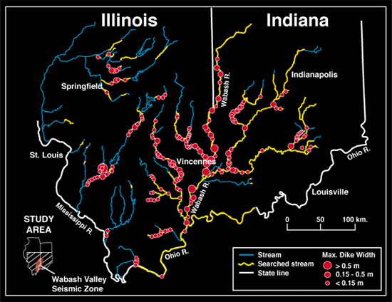
34. Overview of searched region in vicinity
of Wabash Valley. Hundreds of kilometers of streambanks were searched.
Red dots show locations of sites having clastic dikes from paleo-earthquakes.
Each site has from one dike to hundreds of dikes, averaging about
five. The size of the red dot is indexed to the size of the widest
dike at a site. (A site is defined as a continuous exposure of
clean banks with dikes, in which the host sediments have approximately
the same age.)
The largest paleo-earthquakes were of mid-Holocene age. The strongest was a M~7.5 earthquake, which struck in 6,100 yr BP. The following slides concentrate on effects of that earthquake.
All data and interpretations in this slide and in slide 43 are from the following reports:
McNulty, W.E., and Obermeier, S.F., 1997, U.S. Geological Survey Open-File Report 97-435.Munson, P.J., Obermeier, S.F., Munson, C.A., and Hajic, E.R.,1997, Seismological Research Letters, vol. 68, no. 4, p. 521-536..
Obermeier, S.F., 1998, Liquefaction evidence for strong earthquakes of Holocene and latest Pleistocene ages in the states of Indiana and Illinois: Engineering Geology, v. 50, p. 227-254.
For more information, contact Stephen F. Obermeier