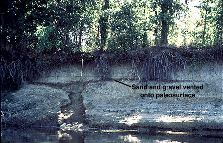
36. This view shows a 0.7-m-wide dike from lateral spreading along the banks of the Wabash River. Site was not modified by man before photograph was taken. White vertical scale in slide is 1 m. Sand and gravel were vented onto the ground surface in the earthquake of 6,100 yr BP; subsequently, after the earthquake, about 1 m of overbank silty clay was deposited onto the vented sediment as a result of frequent flooding. The vented sand and gravel portion is the dark, thin band parallel to the modern ground surface. Six dikes of width exceeding 0.5 m were found at scattered sites in the meizoseismal zone of the 6,100 yr BP earthquake. The widest dike was 2.5 m. (Slide courtesy of Cheryl A. Munson, Indiana University.)
For more information, contact Stephen F. Obermeier