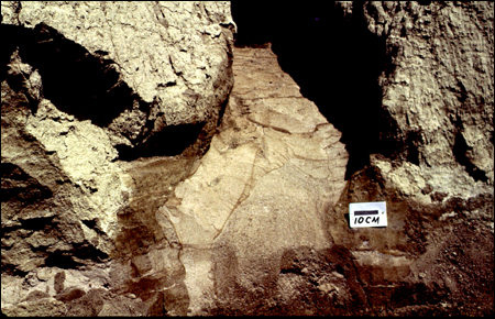

42. This slide shows a common phenomenon
in which the clastic infilling in a dike has very different grain
sizes that are separated by a sharp vertical boundary. This photograph
is a vertical view of a portion (near the base) of a 0.5-m-wide
lateral spread in the banks of the Wabash River, which developed
in the earthquake of 6,100 yr BP. A 8- to 15-cm-wide dike of medium
sand cuts into coarser sand that was previously intruded. There
is only slight weathering in the two sizes of sand. At this location,
the two sand sizes represent liquefaction from different source
beds at depth, from the same earthquake.
Even small dikes commonly contain dikes that have formed within one another, from the same earthquake.
For more information, contact Stephen F. Obermeier