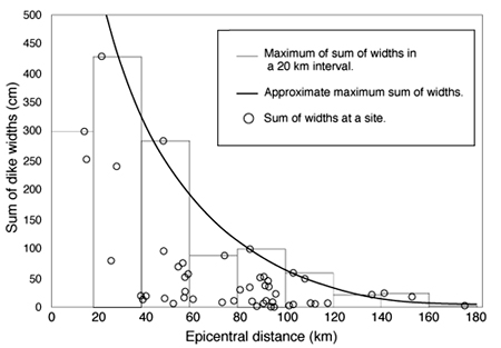
44. This slide shows dike width for the earthquake of 6,100 yr BP as a function of distance from the meizoseismal zone. Widths are shown for dikes along the Wabash River and all sites eastward in Indiana. (A similar plot results for dikes westward in Illinois.) The widest dikes define the meizoseismal zone, and dike widths attenuate systematically with distance away from there. The monotonic attenuation indicates that the dikes were formed by a single, very large earthquake; as will be seen, this conclusion is strongly supported by geotechnical analysis (using back-calculated accelerations) at sites of liquefaction caused by that earthquake.
For more information, contact Stephen F. Obermeier