 |
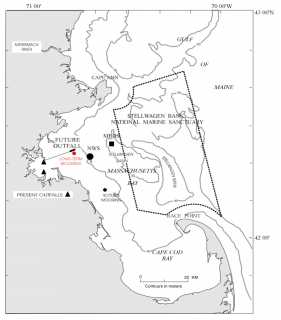
| Time-series photographs of the seafloor were obtained at a site in western Massachusetts Bay between June and October of 1996. The long-term monitoring station is just to the south of the location of the new ocean outfall that will begin discharging treated effluent in 1999. The photographs are part of a suite of observations obtained by the U.S. Geological Survey to monitor sediment resuspension and transport in Massachusetts
Bay. The observations are made in cooperation with the Massachusetts Water Resources
Authority.
|
|
Based on U.S. Geological Survey Open-file Report 98-797
November 1998 |
Bradford Butman1, John Evans1, William N. Lange2,
and Chris Polloni1
1 U.S. Geologic Survey, Woods Hole, Massachusetts
2Woods Hole Oceanographic Institution, Woods Hole, Massachusetts
|
--DISCLAIMER--
This report is preliminary and has not been reviewed for
conformity with U.S. Geological Survey editorial standards or with the North
American Stratigraphic Code. The use of trade, product, or industry names in this report is for descriptive or location purposes only and does not constitute endorsement of products by the U.S. Government. Opinions and conclusions expressed herein do not necessarily represent those of the USGS.
|
| |