Construction of Digital Bathymetry for the Gulf of Maine

Authors: Ed Roworth & Rich Signell

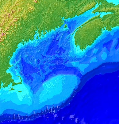
On these pages we document the procedures we used to construct 15 arc second (~1/2 km grid cell size) and 30 arc second (~1 km grid cell size) resolution bathymetric grids for the Gulf of Maine (Longitude = 71.5 - 63 W, Latitude = 39.5 - 46 N). The goal was to construct the best gridded products possible using available digital bathymety datasets.  In addition to the grids themselves, valuable ancillary products such as corrected sounding data, digital bathymetric contour lines and shaded-relief maps were generated and are available in a variety of formats, including Arc, Matlab, GMT and ASCII.


Introduction to Gulf of Maine Bathymetry
 
Assembling the Input Data
1. NOAA Hydrographic Survey Data and NGDC Marine Trackline Geophysics Data
2. Naval Oceanographic Office DBDB-V gridded bathymetry
3. Datasets from Bedford Institute of Oceanography and Brookhaven National Laboratory
4. NOAA Medium Resolution Digital Shoreline and DMA World Vector Shoreline
5. Defense Mapping Agency ETOPO5 Digital Relief of the Surface of the Earth
6. GEBCO General Bathymetric Chart of the Oceans
7. USGS North American 30 Arc-Second DEM

Generating the Bathymetric Grids

Data Products
1. Images: for graphics packages and map overlays.
2. Grids: The 15 and 30 second grids in Arc, GMT, Matlab and ASCII formats.
3. Contours: ArcInfo and Matlab (a simple ASCII format)
4. The processed sounding files in ASCII format: 3 column flat files containing longitude, latitude and elevation
 
Appendix
Metadata
References


Fly-By Movie of the Gulf of Maine (1.7 Mb MPEG)


[an error occurred while processing this directive]