
| Environmental Geochemistry and
Sediment Quality in Lake Pontchartrain |
Guide to the AREA_CODE Field
Below is a map of the areas used in the AREA_CODE field, along with a table showing
both the codes and the descriptions. You may download a
file delineating these areas. The files in this zipped file are in MapInfo's export
format (MID/MIF pair).
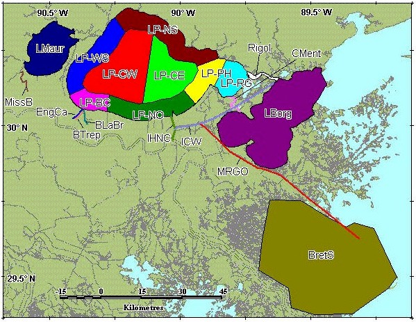
| AREA_CODE |
AREA_DESCRIPTION |
| BLaBr |
Bayou LaBranche |
| BretS |
Breton Sound |
| BTrep |
Bayou Trepagnier |
| CMent |
Chef Menteur |
| EngCa |
Engineers Canal |
| ICW |
Intra Coastal Waterway |
| IHNC |
Inner Harbor Navigation Canal |
| LBorg |
Lake Borgne |
| LMaur |
Lake Maurepas |
| LP-BC |
Lake Pontchartrain, Bonnet Carré region |
| LP-CE |
Lake Pontchartrain, central region east of Causeway |
| LP-CW |
Lake Pontchartrain, central region west of Causeway |
| LP-NO |
Lake Pontchartrain, New Oreleans region |
| LP-NS |
Lake Pontchartrain, north shore region |
| LP-PH |
Lake Pontchartrain, Pointe aux Herbes region |
| LP-RG |
Lake Pontchartrain, Rigolets region |
| LP-WS |
Lake Pontchartrain, west shore region |
| MissB |
Mississippi Bayou |
| MRGO |
Mississippi River Gulf Outlet |
| Rigol |
Rigolets |
 Back to Data Sources and
Locations Back to Data Sources and
Locations
|