Holocene Geologic Framework of Lake Pontchartrain Basin and Lakes
of Southeastern Louisiana
Jack L. Kindinger
(link to Summary Table of Figures)
| The
Lake Pontchartrain Basin is a 12,170-km2 (4,700-mi2) watershed in
southeastern Louisiana, stretching from the State of Mississippi on the north and east to
the Mississippi River on the west and south, and to Breton Sound at the Gulf of Mexico.
The Pontchartrain Basin is about 200 km along strike and 75 km along dip with modern lakes
(Maurepas, Pontchartrain, and Borgne) covering the southern portion of the basin. Lake
Pontchartrain and its adjacent lakes form one of the largest estuaries in the United
States. Nearly 1.5 million people (one-third of the entire population of Louisiana) live
in the 14 parishes of the Lake Pontchartrain Basin. Incised Pleistocene terraces bound
the basin to north, the Mississippi River delta plain to the south/southwest, and the
Chandeleur Islands to the south/southeast. Over the last 150 years, urban growth of New
Orleans and the north shore communities and associated exploitation of natural resources
have severely altered the environmental quality of the basin. In 1994, the USGS began a
multidisciplinary evaluation of the geology, geomorphology, coastal processes, and
environmental quality of the Pontchartrain Basin for use by Federal, state and local
officials in coastal management and restoration planning.
Existing geological information has been integrated with newly acquired
bathymetry, high-resolution seismic and sonar profiles, vibracores, boxcores, and
geochemical data to develop a geologic history and record of sediment distribution of the
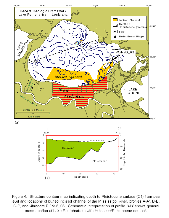
basin (Fig. 1, Fig. 2).
The Pontchartrain Basin has a complex depositional history, a result of sedimentary
processes controlled by sea-level change. During the late Wisconsin lowstand, the region
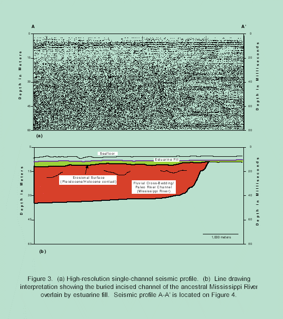
was entrenched by rivers. A buried incised channel of the ancestral Mississippi River,
identified from seismic profiles (see Fig. 3 A-A’),
underlies the southern margin of Lake Pontchartrain. The incision is three to four km
across, was cut to a depth of 40 m, and can be traced from west to east into Lake
Pontchartrain (Fig. 4). Sea-level rise during
deglaciation truncated the filled paleochannel and the surrounding region of the
Pontchartrain Basin. The ravinement surface is a sharp contact with siderite nodules and
has been identified from vibracores, boring, and interpreted from seismic profiles as the
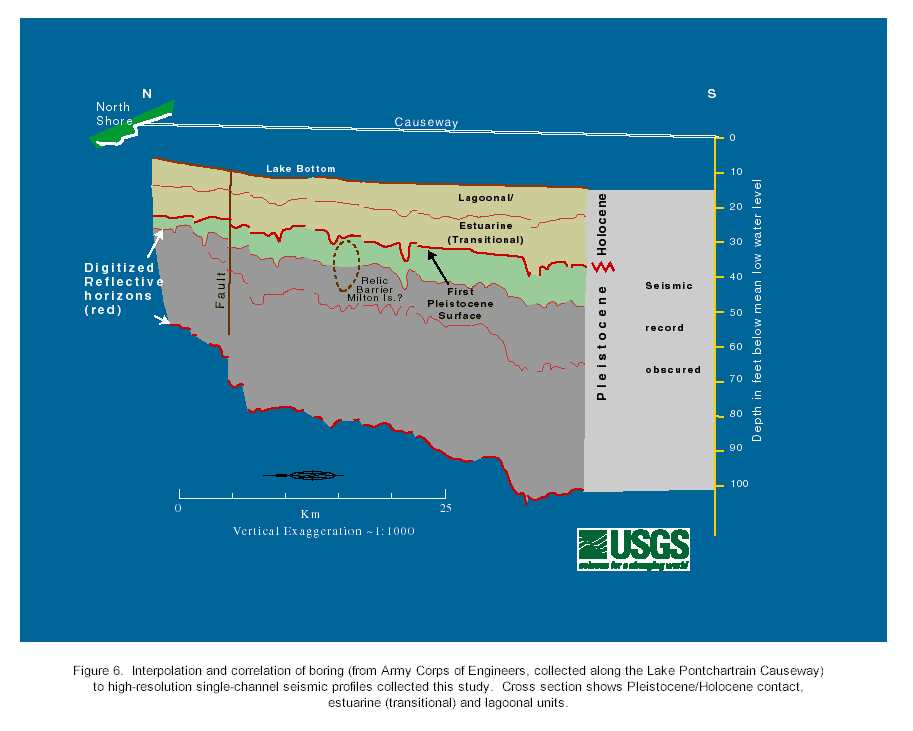
Pleistocene-Holocene contact (Fig. 5, Fig. 6, Fig.
7). The late Pleistocene unit is typically described as a stiff, olive-gray to light
grayish-yellow clay that is highly bioturbated. The burrows are filled with oxidized
organics or sand and silt. The structure contour map (Fig.
4) of the Pleistocene surface shows the contact is shallow (near the sediment surface,
2 m below sea level) in northeast Lake Pontchartrain and deeper (20 m below sea level) to
the southwest. Cross section A-A’ (Fig. 4)
illustrates how the Pleistocene contact crops out along the northeast shore and dips to
the southwest.
Due in part to structure of the Pleistocene surface and in part to deltaic deposition
from the Mississippi River, Holocene sedimentation has occurred in at least five episodes.
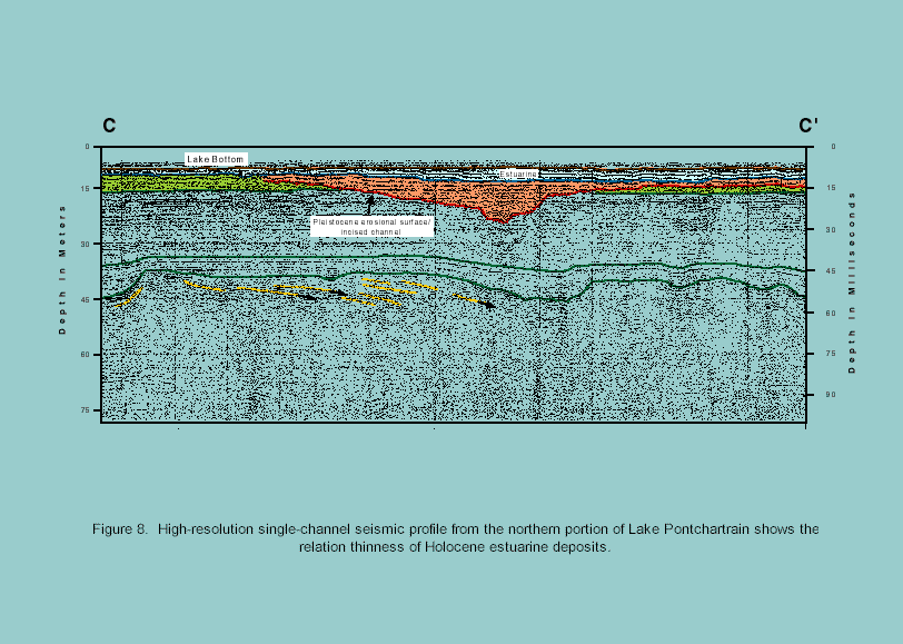
Holocene sediments in Lake Pontchartrain were differentially deposited to the north (~0.3
m thick; Fig. 5 and Fig.
8) and south (~5.0 m thick). Of the five episodes, two were not extensive and could
not be mapped, but three units above the Pleistocene-Holocene contact have been delineated
(Fig. 7). As the basin flooded, the first sediment unit
began to accumulate in topographic lows in the west-central part of the lake near the
Mississippi River (Fig. 4). The oldest Holocene unit (B 2, thickness of 2.0+ m, Fig.
5) is described as soft gray clay sporadically interbedded with fine sand, horizontal
laminations, isolated lenticular bedding, sand-filled burrows, and rafted organics. Unit B2 is completely burrowed. Unit B1 overlies unit B2 and is composed of
a soft, silty, fine sand interbedded with clay and/or clay clastics, shell fragments, and
small rafted organics (coffee grounds). Unit B1
averages 1.0 m thick. The uppermost unit in the section, A1 (>1.0 m thick), is a burrowed, soft dark gray to grayish-brown clay with
massive bedding containing small shells and shell fragments. Unit A1 is
possibly a disturbed zone as a result of heavy commercial shell dredge activity from 1930s
to 1990. Each of these units has sharp basal contact. Units A1 and B1 have the largest aerial
distribution.
Sea-level rise flooded the "Pontchartrain Embayment" between 6,000 to 4,000
BP (Fig. 9) and deposited transgressive nearshore or
lagoonal/estuarine sediments across the area over the ravinement surface. A stillstand at
~4,000 BP initiated formation of a barrier shoreline. Sediments eroding from Pleistocene
terraces and Pearl River delta shores to the east of the Pontchartrain Embayment, combined
with sandy material moving westward along the Alabama-Mississippi shore, built the large
recurved spit and barrier (Pine Island Barrier Trend; Fig
10) that bounds the southeast part of the basin. Back-barrier deposits and shell reefs
partially filled the open estuary. The next depositional event (at ~3,000 BP) was the
eastward progradation of the St. Bernard delta complex and other subdeltas from the
Mississippi River valley. Deltaic sediments enclosed the Pontchartrain Basin to the south
and eventually covered the Pine Island Barrier, forming Lake Pontchartrain. At that time,
the basin began to accumulate prodelta, delta front, and crevasse deposits. Cypress swamps
and fresh water marshes formed in the upper basin and intermediate to saline marshes
formed in the lower basin. From ~3,000 BP to the present, active growth faults have also
influenced basin geometry and geomorphology, particularly along the north shore.
Although the depositional history is complex, sea-level change has controlled the
development of estuaries in the northern Gulf of Mexico (Fig. 11). Many similarities exist among the gulf estuaries. The same
processes that formed and flooded the incised valleys of Mobile Bay to the east and Sabine
Lake to the west formed Lake Pontchartrain. Each of these estuaries was an open bay that
was closed or partially closed by westward movement of shoreline sands that formed spits
or cheniers. Mobile Bay was partially closed by sands forming Morgan Peninsula. Sabine
Lake was fully closed by the sands forming the chenier plain of western Louisiana. Lake
Pontchartrain was partially closed by sands forming the Pine Island Barrier Trend. The
embayment was then fully cut off by Mississippi River subdeltaic deposition. Evolution of
each of these bays is linked by the processes that have formed them. |
Figure 1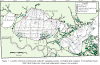 |
Figure 2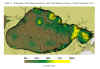 |
Figure 3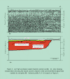 |
Figure 4 |
Figure 5 |
Figure 6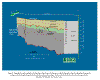 |
Figure 7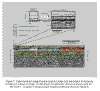 |
Figure 8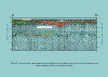 |
Figure 9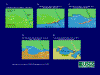 |
Figure 10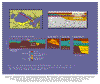 |
Figure 11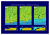 |
|