
| Environmental Geochemistry and
Sediment Quality in Lake Pontchartrain |
Bonnet Carré Spillway Event
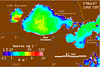
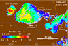
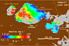
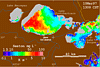
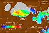
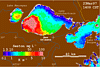
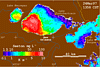
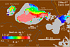
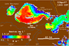
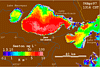
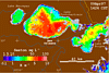
These images of Lake Pontchartrain, Louisiana, were derived from data collected by the
Advanced Very High Resolution Radiometer (AVHRR) onboard NOAA polar-orbiting weather
satellites. Water reflectance measured in the visible and near-IR wavelengths are
determined with corrections for atmospheric effects, and converted to provisional
estimates of suspended sediment concentration (seston) and diffuse attenution coefficient
(K). These values have not been validated and are provided for context only. Clouds are
masked in gray; land in brown.
Due to the recent Midwest flooding, the Bonnet Carré Spillway was opened at
approximately 80% maximum on March 17, 1997. The Bonnet Carré Spillway connects the
Mississippi River to Lake Pontchartrain and enters the lake in the southwest corner,
half-way between Lake Maurepas and New Orleans. These images illustrate the increase in
suspended material in the lake as a result of the diversion of flood waters.
 March 3, 1997 March 3, 1997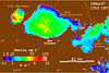 March 6, 1997 March 6, 1997
 March 7, 1997 March 7, 1997
 March 8, 1997 March 8, 1997
 March 9, 1997 March 9, 1997
 March 10, 1997 March 10, 1997
 March 11, 1997 March 11, 1997
 March 18, 1997 March 18, 1997
 March 23, 1997 March 23, 1997
|
 March 24, 1997 March 24, 1997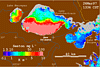 March 26, 1997 March 26, 1997
 March 27, 1997 March 27, 1997
 March 29, 1997 March 29, 1997
 April 2, 1997 April 2, 1997
 April 6, 1997 April 6, 1997
 April 7,1997 April 7,1997
 April 9, 1997 April 9, 1997
|
 Back to Lake Pontchartrain Basin Imagery
|