| Environmental Geochemistry and
Sediment Quality in Lake Pontchartrain |
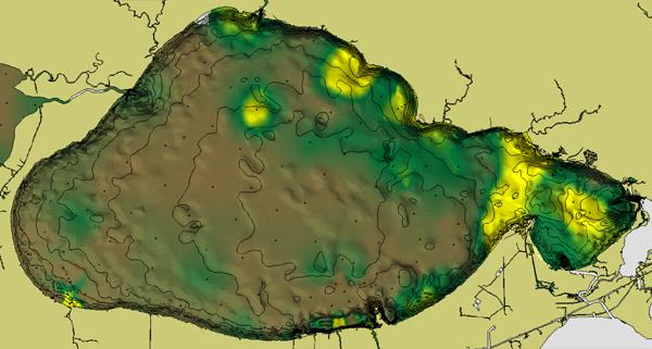
Sediment Texture and Bathymetry (Figure 12)
Lakes Pontchartrain and Maurepas are shallow, as seen in the bathymetry
contours in the following
figure. Sand content in percent is depicted with bathymetry overlaid in contours and
shading. Maximum depth of about 5 m occurs in the deepest part of Lake Pontchartrain and
in dredged areas near the New Orleans shore. Sand content (2.0 to .16 mm grain diameter),
compiled from all quantitatively-located sources, show maximum concentrations in the
narrow entry channel area (Rigolets), and in trends in the northern part of Lake
Pontchartrain. Local increases of coarse sediments also occur in nearshore areas adjacent
to the Bonnet Carré Spillway. Note that the percentage of "sand and
gravel" based on size analysis is influenced by the presence of clam shells (Rangia).
The earlier extensive dredging of the Lakes for shell recovery means that dredged samples
will be finer-grained than sediments that have never been dredged. |
Figure 12.
 |
30.4°N |
| 30.0°N |
| 90.45°W |
89.72°W |
| Grain size distribution (sand percent in colors) draped over bathymetry
(shading and contours). Contour interval is 0.5 meters with the deepest contour in the
middle of the lake being 4.5 meters. In general, Lakes Pontchartrain and Maurepas have
relatively fine sediment accumulations, with sands (2.0 - 0.16 mm diameter) occurring
mainly in the eastern margin near the Rigolets, and in the northern part of Lake
Pontchartrain. Previous authors (Penland et al., 1988; Flowers and Isphording, 1990)
suggest that these sandy areas may be relicts of earlier offshore bar and beach trends. |
 Back to Sediment Texture and
Bathymetry Back to Sediment Texture and
Bathymetry
|