III. Data and Preliminary InterpretationsA. Sediment Texture and Bathymetry
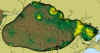
Lakes Pontchartrain and Maurepas are shallow, as seen in the bathymetry contours in Fig. 12. Maximum depth of about 5 m occurs in the deepest part of Lake Pontchartrain and in dredged areas near the New Orleans shore (see inset, Fig. 13). The percentage of sand (defined as the size fraction between 2.0 to 0.16 mm grain diameter) compiled from all quantitative and specifically-located sources except recent EMAP (1998) data, is overlaid on Figures 12 and 13. Significant sand fractions are found only in the narrow entry channel area (Rigolets), and in trends in the northern and eastern part of Lake Pontchartrain. High concentrations of coarse sediments also occur in small, nearshore areas adjacent to the Bonnet Carré Spillway. In the remainder of the Lake area the sand content is usually less than 10%. As pointed out by Flowers and Isphording (1990), Lake Pontchartrain and Maurepas sediments have the finest grain sizes of all major Gulf of Mexico estuaries. The reason for this fineness may be seen in the classical delineation of pre-European settlement environments surrounding the lake (Saucier, 1960; Fig. 14). Much of the shoreline is swampy lowlands, which limit influx of coarser sediments. A small amount of coarse material is transported by strong currents through the narrow Rigolets channel. A much larger amount of material of sand fraction size has been transported historically through "crevasses" or breakthrough channels from the Mississippi River during floods and high stages, as noted in the section on the Bonnet Carré Spillway. However, most of the coarse fraction is dropped within a few kilometers of the entry channel, leaving mostly silts and clay to be transported farther into the lake. It should be noted that the texture distribution as shown in Fig. 12, based on the data in Appendix D, refers to surface sediments, commonly defined by thicknesses recovered by Ponar and similar shallow grab samples. In undredged (undisturbed) areas, significant concentrations of Rangia clams make up most of the coarse fraction. A large part of the lake bottom, estimated at about two-thirds, has been dredged at various times in the past, until prohibition of dredging in 1990 (see USACE, 1987). The sediment texture shown in Fig. 12 is, thus, influenced both by removal of most of the clam-shell debris in dredged sites, and by mixing of deeper and surface layers down to a depth of 1 m or more as dredge waste was returned to the lake. In a large part of the lake, surficial sediments may be similar in texture to naturally-occurring sediments prior to dredging. However, in the isolated high-sand anomalies in Fig. 12 and perhaps other areas, dredging operations of 1 m or more may have mixed sands from buried deposits into surficial sediments. Modelling of wind-and tide-driven waves and currents suggests that coarser sediments
like sands would be distributed around the periphery of Lake Pontchartrain (Signell and others, this publication). However, the constraints on
sediments delivered to the lake strongly limit the distribution of sands. The prevalence
of sand in the northern and eastern parts of the lake therefore appears to be due to the
occurrence of older barrier bars and beaches, exemplified by the Milton Island and Pine
Island trends (Penland and others, 1988; Flowers and Isphording, 1990; Saucier, 1996).
|
||||||||||