Skip Links

USGS - science for a changing world

Open-File Report 99-317

Digital Data for the Geologic Framework of the Alaska Peninsula, Southwest Alaska, and the Alaska Peninsula Terrane

By Frederic H. Wilson, Robert L. Detterman, and Gregory Dubois

Thumbnail of and link to report PDF (3 MB)Introduction

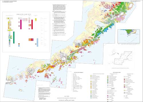
These digital databases are the result of the compilation and reinterpretation of published and unpublished 1:250,000- and 1:63,360-scale mapping. The map area covers approximately 62,000 sq km (23,000 sq mi) in land area and encompasses much of 13 1:250,000-scale quadrangles on the Alaska Peninsula in southwestern Alaska. The compilation was done as part of the U.S. Geological Survey's Alaska Mineral Resource Assessment project (AMRAP), whose goal was create and assemble geologic, geochemical, geophysical, and other data in order to perform mineral resource assessments on a quadrangle, regional or statewide basis. The digital data here was created to assist in the completion of a regional mineral resource assessment of the Alaska Peninsula.

Mapping on the Alaska Peninsula under AMRAP began in 1977 in the Chignik and Sutwik Island 1:250,000 quadrangles (Detterman and others, 1981). Continued mapping in the Ugashik, bristol bay, and northwestern Karluk quadrangles (Detterman and others, 1987) began in 1979, followed by the Mount Katmai, eastern Naknek, and northwestern Afognak quadrangles (Riehle and others, 1987; Riehle and others, 1993), the Port Moller, Stepovak bay, and Simeonof Island quadrangles (Wilson and others, 1995) beginning in 1983. Work in the Cold bay and False Pass quadrangles (Wilson and others, 1992 [Superceded by Wilson and others 1997, but not incorporated herein]) began in 1986.

The reliability of the geologic mapping is variable, based, in part, on the field time spent in each area of the map, the available support, and the quality of the existing base maps. In addition, our developing understanding of the geology of the Alaska Peninsula required revision of earlier maps, such as the Chignik and Sutwik Island quadrangles map (Detterman and others, 1981) to reflect this new knowledge. We have revised the stratigraphic nomenclature (Detterman and others, 1996) and our assignment of unit names to some rocks has been changed.

All geologic maps on which this compilation is based were published using the Universal Transverse Mercator projection (UTM; Zones 3, 4, and 5). because of the distortions use of the UTM projection would produce on a map of small scale and large area, the plot and graphics files derived from this data are plotted using a more appropriate Albers Equal-area projection for publication.

First posted February 20, 2001

Arc Export files of the geology for each tier of quadrangles

UTM projection

Geographic coordinates

mkgeol.e00

file size: 7.9 Mb

mkgeolg.e00

file size: 7.9 Mb

uggeol.e00

file size: 4.0 Mb

uggeolg.e00

file size: 3.9 Mb

cggeol.e00

file size: 5.2 Mb

cggeolg.e00

file size: 5.2 Mb

pmgeol.e00

file size: 5.3 Mb

pmgeolg.e00

file size: 5.2 Mb

cbgeol.e00

file size: 3.3 Mb

cbgeolg.e00

file size: 3.3 Mb

Other Export files

krc45.e00

file size: 76 kb

Albers Equal-Area Projection

Geographic Coordinates

mkfld-alb.e00

file size: 9 kb

mkfldg.e00

file size: 10 kb

ugfld-alb.e00

file size: 88 kb

ugfldg.e00

file size: 98 kb

cgfld-alb.e00

file size: 144 kb

cgfldg.e00

file size: 170 kb

pmfld-alb.e00

file size: 42 kb

pmfldg.e00

file size: 51 kb

cbfld-alb.e00

file size: 12 kb

cbfldg.e00

file size: 15 kb

akpencst.e00

file size: 2.5 Mb

akpencstg.e00

file size: 2.6 Mb

EPS files

akpen.eps (14 Mb)

postscript file of geologic map

akpencor.eps (303 kb)

correlation chart

penindex.eps (562 kb)

index map

inseta.eps (345 kb)

inset map of part of the Karluk C-4/5 quadrangle

Hewlett-Packard graphics language file

akpen.jet (6 Mb)


MS Word97/98 file

APMAP.DOC (196 Mb)

MS Word97/98 version of text to accompany map

Adobe Acrobat PDF files of mapsheet and text

aptext.pdf (236 kb)

text

akpen.pdf (3 mb)

map

ARC Graphics files

akpencor.gra (45 kb)

correlation chart

penindex.gra (63 kb)

index map

inseta.gra (55 kb)

inset map of part of the Karluk C-4/5 quadrangle

ARC-related files

akpenofr.aml (8 kb text file)

AML file needed to re-construct map

Ancillary text files

mapcred.pen (3 kb)

credit note for geologic mapping

basecred.pen (1 kb)

note for base map credit

penin1d.key (< 1 kb)

ARC key file used to produce list of map units

penin2d.key (1 kb)

ARC key file used to produce list of map units

penin3d.key (< 1 kb)

ARC key file used to produce list of map units

geoline.key (< 1 kb)

ARC key file used to produce list of line symbols

utm3-alb.prj (< 1 kb)

Project file used to change map projection at plot time

utm4-alb.prj (< 1 kb)

Project file used to change map projection at plot time

utm5-alb.prj (< 1 kb)

Project file used to change map projection at plot time

Lookup tables, symbolsets, and fonts

fnt020 (48 kb)

fnt025 (48 kb)

fnt036 (48 kb)

fnt040 (48 kb)

geoline.lut.e00
(8 kb)

geology.lin.e00
(37 kb)

geology.mrk.e00
(11 kb)

geology.shd.e00
(304 kb)

geology4.lut.e00
(4 kb)

geology5.lut.e00
(4 kb)

geology6.lut.e00
(4 kb)


For additional information, contact:
Alaska Science Center
U.S. Geological Survey
4210 University Dr. 
Anchorage, AK 99508

Part or all of this report is presented in Portable Document Format (PDF). For best results viewing and printing PDF documents, it is recommended that you download the documents to your computer and open them with Adobe Reader. PDF documents opened from your browser may not display or print as intended. Download the latest version of Adobe Reader, free of charge.


Suggested citation:

Wilson, Frederic H., Detterman, Robert L., Dubois, Gregory D., 1999, Digital Data for the Geologic Framework of the Alaska Peninsula, Southwest Alaska, and the Alaska Peninsula Terrane: U. S. Geological Survey Open-File Report 99-317, https://pubs.usgs.gov/of/1999/0317/.


Accessibility FOIA Privacy Policies and Notices

Take Pride in America logo USA.gov logo U.S. Department of the Interior | U.S. Geological Survey
URL: http://pubsdata.usgs.gov/pubs/of/1999/0317/index.html
Page Contact Information: GS Pubs Web Contact
Page Last Modified: Wednesday, 07-Dec-2016 17:49:58 EST