
National Geochemical Database:
U.S. Geological Survey RASS
(Rock Analysis Storage System)
geochemical data for Alaska
U.S. Geological Survey
Open-File Report 99-433
By: Elizabeth A. Bailey1, David B. Smith2, Carl C. Abston2,
Matthew Granitto3, and Kuuipo A. Burleigh4
2000
Version 2.0
1USGS, 4200 University Drive, Anchorage, AK 99508
2USGS, Box 25046, Denver Federal Center, MS 973, Denver, CO 80225
3Potomac Management Group, Box 25046, Denver Federal Center, MS 973, Denver, CO 80225
4Raytheon STX, 4200 University Drive, Anchorage, AK 99508
Brief History and Introduction
Description of data
Metadata
Alaska 1:250,000-scale Quadrangle Index Map
Explanation
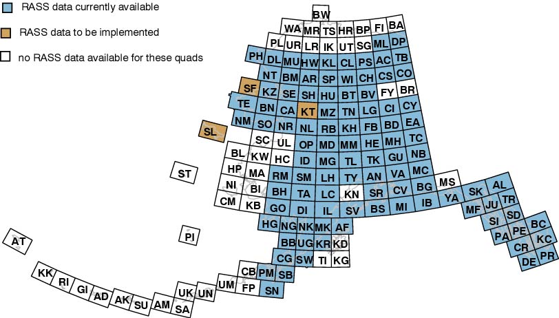
List of quadrangles with RASS data
Quadrangle names in black will be implemented at a later date.- Afognak Quadrangle
- Ambler River Quadrangle
- Anchorage Quadrangle
- Arctic Quadrangle
- Atlin Quadrangle
- Baird Mts Quadrangle
- Beaver Quadrangle
- Bendeleben Quadrangle
- Bering Glacier Quadrangle
- Bethel Quadrangle
- Bettles Quadrangle
- Big Delta Quadrangle
- Blying Sound Quadrangle
- Bradfield Canal Quadrangle
- Bristol Bay Quadrangle
- Candle Quadrangle
- Chandalar Quadrangle
- Chandler Lake Quadrangle
- Charley River Quadrangle
- Chignik Quadrangle
- Christian Quadrangle
- Circle Quadrangle
- Coleen Quadrangle
- Cordova Quadrangle
- Craig Quadrangle
- De Long Mtns Quadrangle
- Demarcation Point Quadrangle
- Dillingham Quadrangle
- Dixon Entrance Quadrangle
- Eagle Quadrangle
- Fairbanks Quadrangle
- Goodnews Quadrangle
- Gulkana Quadrangle
- Hagemeister Island Quadrangle
- Healy Quadrangle
- Howard Pass Quadrangle
- Hughes Quadrangle
- Icy Bay Quadrangle
- Iditarod Quadrangle
- Iliamna Quadrangle
- Juneau Quadrangle
- Kantishna River Quadrangle
- Karluk Quadrangle
- Kateel River Quadrangle
- Ketchikan Quadrangle
- Killik River Quadrangle
- Kotzebue Quadrangle
- Lake Clark Quadrangle
- Lime Hills Quadrangle
- Livengood Quadrangle
- McCarthy Quadrangle
- McGrath Quadrangle
- Medfra Quadrangle
- Melozitna Quadrangle
- Middleton Island Quadrangle
- Misheguk Mtn Quadrangle
- Mt Fairweather Quadrangle
- Mt Hayes Quadrangle
- Mt Katmai Quadrangle
- Mt McKinley Quadrangle
- Mt Michelson Quadrangle
- Nabesna Quadrangle
- Naknek Quadrangle
- Noatak Quadrangle
- Nome Quadrangle
- Norton Bay Quadrangle
- Nulato Quadrangle
- Nushagak bay Quadrangle
- Ophir Quadrangle
- Petersburg Quadrangle
- Philip Smith Mts Quadrangle
- Point Hope Quadrangle
- Port Alexander Quadrangle
- Port Moller Quadrangle
- Prince Rupert Quadrangle
- Ruby Quadrangle
- Russian Mission Quadrangle
- Selawik Quadrangle
- Seldovia Quadrangle
- Seward Quadrangle
- Shishmaref Quadrangle
- Shungnak Quadrangle
- Simeonof Island Quadrangle
- Sitka Quadrangle
- Skagway Quadrangle
- Sleetmute Quadrangle
- Solomon Quadrangle
- St Lawrence Quadrangle
- Stepovak Bay Quadrangle
- Sumdum Quadrangle
- Survey Pass Quadrangle
- Sutwik Island Quadrangle
- Table Mtn Quadrangle
- Taku River Quadrangle
- Talkeetna Quadrangle
- Talkeetna Mountains Quadrangle
- Tanacross Quadrangle
- Tanana Quadrangle
- Taylor Mountains Quadrangle
- Teller Quadrangle
- Tyonek Quadrangle
- Ugashik Quadrangle
- Valdez Quadrangle
- Wiseman Quadrangle
- Yakutak Quadrangle
Quadrangles with no RASS data
- Adak Quadrangle
- Atka Quadrangle
- Amukta Quadrangle
- Attu Quadrangle
- Barter Island Quadrangle
- Baird Inlet Quadrangle
- Black Quadrangle
- Beechey Point Quadrangle
- Black River Quadrangle
- Barrow Quadrangle
- Cape Mendenhall Quadrangle
- Cold Bay Quadrangle
- Flaxman Island Quadrangle
- False Pass Quadrangle
- Fort Yukon Quadrangle
- Gareloi Island Quadrangle
- Holy Cross Quadrangle
- Hooper Bay Quadrangle
- Harrison Bay Quadrangle
- Ikpikpuk River Quadrangle
- Kenai Quadrangle
- Kuskokwim Bay Quadrangle
- Kodiak Quadrangle
- Kaguyak Quadrangle
- Kiska Quadrangle
- Kwiguk Quadrangle
- Lookout Ridge Quadrangle
- Marshall Quadrangle
- Meade River Island Quadrangle
- Mt. St. Elias Quadrangle
- Nunivak Quadrangle
- Pribilof Islands Quadrangle
- Point Lay Quadrangle
- Rat Islands Quadrangle
- Samalga Island Quadrangle
- St. Michael Quadrangle
- Sagavanirktok Quadrangle
- St. Matthew Quadrangle
- Seguam Quadrangle
- Trinity Islands Quadrangle
- Teshepuk Quadrangle
- Umnak Quadrangle
- Unalakleet Quadrangle
- Unimak Quadrangle
- Unalaska Quadrangle
- Utokok River Quadrangle
- Umiat Quadrangle
- Wainwright Quadrangle
History and Introduction
This portion of the RASS database contains geochemical data for Alaska produced by the analytical laboratories of the Geologic Division of the U.S. Geological Survey (USGS). The data represent analyses of stream-sediment, heavy mineral concentrate, soil, and organic material samples. Most of the data comes from mineral resource investigations conducted in the Alaska Mineral Resource Assessment Program (AMRAP). However, some of the data were produced in support of other USGS programs. The data were originally entered into the in-house Rock Analysis Storage System (RASS) database. The RASS database, which contains over 580,000 data records, was used by the Geologic Division from the early 1970's through the late 1980's to archive geochemical data. Much of the data have been previously published in paper copy USGS Open-File Reports by the submitter or the analyst but some of the data have never been published.Over the years, USGS scientists recognized several problems with the database. The two primary issues were location coordinates (either incorrect or lacking) and sample media (not precisely identified). This dataset represents a re-processing of the original RASS data to address these problems and to make the data accessible in digital format and more user-friendly. The re-processing consisted of checking the information on sample media and location against the original sample submittal forms, the original analytical reports, and published reports.
Location coordinate errors were corrected by using the original submittal forms or published reports or by digitizing from the original base maps. All coordinates are now reported in decimal degrees. As necessary, fields were added to the original data to more fully describe the sample preparation methods used and sample medium analyzed. The actual analytical data were not checked in great detail, but obvious errors were corrected. This dataset currently contains 126,272 records for stream sediment, heavy mineral concentrate (derived from stream sediment), soil, and organic material samples collected in Alaska. Additional records will be added as they become available. Rock sample data will be added in the future.
Description of data
See the Metadata for complete information on sample description and analytical data field coding schemes. Printing a copy of the Metadata file will provide users with a handy reference manual.
This dataset contains geochemical data that can be downloaded on a 1:250,000-scale quadrangle basis by sample type(see Map or List). The data for each quadrangle have been sorted by the following sample types:
- Stream sediments
- Heavy mineral concentrates (derived from stream sediment)
- Soils
- Waters
- Organic Materials
- *.WK1 (Lotus 1-2-3, can be loaded into any spreadsheet program)
- *.DBF (Dbase III, can be loaded into any database program)
- *.CSV (Comma-Separated Values, can be loaded into most GIS programs)
Important Note:
Within each sample type there may be several additional sub-sample types (see Metadata for complete description of sample coding). For example, within the stream-sediment sample type, a sample may have been sieved to any one of 54 mesh sizes. Material passing through an 80-mesh sieve (0.18-mm particle size) is most commonly used for analysis; however, finer or coarser fractions may have been used for a variety of reasons. For heavy-mineral-concentrate samples, several sub-sample types may be present in a data file. The C3 fraction (panned in the field, heavy liquid separation followed by magnetic separation in the laboratory) is the fraction most commonly analyzed; however, on some occasions other fractions were used or heavy liquid and/or magnetic separation may not have been performed. In the organic material sample type, the sample may be peat, plants, moss, or other organic material. Users should look carefully at the Description1, Description2, and Mesh_Size fields in each dataset to accurately identify each sample. After downloading a data file users may wish to sort or separate the data by mesh size, concentrate type, type of organic material, etc. before any doing any statistical analyses.Download the Data:
To download a data file, click on the file you wish to download. If you experience trouble downloading files, try pressing the shift key when clicking (Netscape for Windows), or right-clicking (Internet Explorer for Windows), or pressing the option key when clicking (Netscape and Internet Explorer for Macintosh.)
Download files:
Alternatively, the geochem data files can be found in:
data for .xls and .txt
csv .csv
dbf .dbf
wk1 .wk1
Suggestions and Comments
This dataset will be updated periodically as additional data re-processing is completed. If you need help, have questions, comments, or suggestions please email:- Elizabeth A. Bailey eabailey@usgs.gov
Alaska RASS geochemical data - David B. Smith dsmith@usgs.gov
National Geochemical Database
Related links
Alaska NURE data | USGS National Geochemical Database - NURE HSSR data | Alaskan Interagency Minerals Coordinating Group | USGS Mineral Resources Program | USGS Western Region Mineral Resources Program - Alaska Section | The USGS Alaska Resource Data Files
| The information on this page is preliminary and has not been reviewed for conformity with U.S. Geological Survey editorial standards and stratigraphic nomenclature. Any use of trade, product, or firm names on this page is for descriptive purposes only and does not imply endorsement by the U.S. Government. Comments and corrections to information found here are appreciated. |
U.S. Department of the Interior
U.S. Geological Survey
This page is <URL: https://pubs.usgs/of/1999/of99-433/>
Maintained by: Michael Diggles
Last Modified May 9, 2008