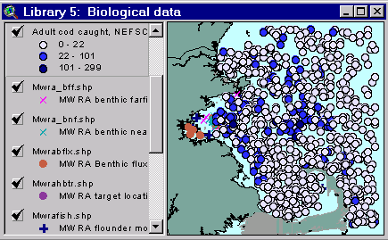
Sample from the ArcView window for Library 5
| Library 5: Biological Data |
Return to TABLE OF CONTENTS |
| To view all the coverages described in this Library, open the view titled Library 5 while running the ArcView project (mbay_30.apr or mbay_31.apr) in the mbaygis directory of this CD-ROM. To view summary metadata (file names, descriptions, provider, references) see the table below. To view complete metadata, go to directory "9_biblio" on this CD-ROM and open the file metadata.mdb using Microsoft Access or the file Gismeta.htm using your browser. |
Sample from the ArcView window for Library 5 |
This library contains boundaries of Essential Fish Habitats as designated by NOAA National Marine Fisheries Service (NMFS), abundance of 15 fish species as determined from spring and fall groundfish surveys, locations of biological sampling stations for the Massachusetts Water Resources Authority Outfall monitoring program, and boundaries of selected marine closure areas.
NMFS Essential Fish Habitat Designation
Essential Fish Habitat (EFH) is derived from provisions in the Magnuson-Stevens Fishery Conservation and Management Act (Magnuson-Stevens Act), as amended by the Sustainable Fisheries Act in 1996. Under the original Magnuson Act passed in 1976, eight Regional Fishery Management Councils were established in part to develop and implement Fisheries Management Plans (FMPs). Under the 1996 amendment, the Councils must amend their respective FMPs to include information on EFH for those species or groups of species included in the FMPs. EFH is defined (Part 600-Magnuson Act Provisions) as "those waters and substrate necessary to fish for spawning, breeding, feeding, or growth to maturity. For the purpose of interpreting the definition of essential fish habitat: "waters" includes aquatic areas and their associated physical, chemical, and biological properties that are used by fish, and may include areas historically used by fish where appropriate; "substrate" includes sediment, hard bottom, structures underlying the waters, and associated biological communities; "necessary" means the habitat required to support a sustainable fishery and a healthy ecosystem; and "spawning, breeding, feeding, or growth to maturity" covers a species’ full life cycle."
The Essential Fish Habitat coverages provided on this CD-ROM are draft, as acceptance is awaiting the signature of the Secretary of the US Department of Commerce. The National Marine Fisheries Service, Habitat Conservation Office in Silver Spring, Maryland (301-713-2325) can provide direction for additional information. Ten minute grid squares are used to show presence and life stage of 24 different species.
New England Fishery Management Council homepage: http://www.nefmc.org/nefmc_main.htm
Species managed by the Council (with images): http://www.nefmc.org/overview/species.htm
Inshore and Offshore Groundfish Surveys from Massachusetts Division of Marine Fisheries (MA-DMF) and NOAA Northeast Fisheries Science Center (NEFSC)
Abundance of juveniles and adults for 15 species, based on the spring and fall groundfish surveys, was compiled from data held by the National Marine Fisheries Service. Groundfish data collected between 1978 and 1997 are summarized by species/maturity (juvenile/adult (j/a)) or species/size class (pre-recruit/recruit (p/r)). The number of fish and invertebrates caught at each sampling location in each maturity/size class was determined and is found in the appropriate columns.
Data for 15 species of fish/squid listed below are found in the files fish_ma.shp (the inshore data from Massachusetts Division of Marine Fisheries) and fish_nef.shp (the offshore data from Northeast Fisheries Science Center, National Marine Fisheries Service). Data for each survey are presented in separate files because of differences in collecting gear used and timing of the surveys; the data are not directly comparable and should be examined and displayed separately. Common names, corresponding column titles, and cutoff (cm) for maturity/size class are presented below
|
COMMON NAME |
COLUMN HEADINGS* |
JUVENILES |
ADULTS |
|
Atlantic Herring |
herring_j/a |
<=24 |
>=25 |
|
Silver Hake |
s_hake_j/a |
<=22 |
>=23 |
|
Atlantic Cod |
cod_j/a |
<=34 |
>=35 |
|
Haddock |
haddock_j/a |
<=31 |
>=32 |
|
Pollock |
pollock_j/a |
<=38 |
>=39 |
|
White Hake |
w_hake_j/a |
<=34 |
>=35 |
|
Red Hake |
red_hake_j/a |
<=25 |
>=26 |
|
American Plaice |
plaice_j/a |
<=26 |
>=27 |
|
Yellowtail Flounder |
yel_flou_j/a |
<=26 |
>=27 |
|
Witch Flounder |
wit_flou_j/a |
<=29 |
>=30 |
|
Windowpane Flounder |
win_flou_j/a |
<=21 |
>=22 |
|
Ocean Pout |
pout_j/a |
<=29 |
>=30 |
|
Goosefish |
goosef_j/a |
<=42 |
>=43 |
|
PRE-RECRUITS |
RECRUITS |
||
|
Shortfin Squid |
sf_squid_p/r |
<=10 |
>=11 |
|
Longfin Squid |
lf_squid_p/r |
<=7 |
>=8 |
*Note: either "j" or "a" is used as the last letter of the column heading to indicate adults or juveniles; likewise, "p" and "r" indicate pre-recruits and recuits.
In addition to the columns for each species/maturity and the default columns such as area and unique id, theses shapefiles also contain data columns for:
|
bottom temperature, in º C |
"bottemp" |
|
setdepth for trawl, in meters |
"setdepth" |
|
season, spring or fall |
"season" |
Click here for list of references for these data.
Fish_nef.shp and Fish_ma.shp are each loaded into the Library 5 View twice; once with a "single symbol" legend showing each station location, and once with a "graduated color" legend specifically showing abundance of adult cod at each station. The data are identical in each theme, but the latter is an example of how to display the abundance of one species/maturity by breaking the values into classes and using a different color dot for each class. (The inshore and offshore layers are shown in different color schemes since, as indicated above, the 2 data sets are not directly comparable.) To display the abundance of another species/maturity, load another copy of the shapefile to the view, change the legend type to "graduated color" in the legend editor, choose the species/maturity to view for "classification field", change the number of classes with the "Classify" button if desired, choose a color ramp, and apply the legend. The user may also want to locate stations with certain attributes (i.e. stations where at least one juvenile herring was caught in the spring, or stations where the bottom temperature was greater than 15º C and the set depth for the trawl was less than 20m) by using the Query dialog box.
MWRA Harbor and Outfall Monitoring Stations
The MWRA is carrying out an extensive program to monitor water quality, sediment chemistry, and biota before and after the new ocean outfall begins operation (Albro and others 1998; Kropp and Boyle, 1998; Tucker and Giblin, 1998; Lefkovitz and Moore, 1998). The location of stations were carefully selected based on the simulations of water quality (Signell, 1996) topography (Knebel and others, 1996), and sediments (see coverages in Chapter 3).
Coverages provided in Library 5 include:
Benthic stations (Kropp and Boyle, 1998)
Hard bottom survey transects (Kropp and Boyle, 1998)
Benthic nutrient flux stations (Tucker and Giblin, 1998)
Fish and shellfish stations (Lefkovitz and Moore, 1998)
Coverages provided in Library 5:
(Summary metadata for files in the Library 5 view are listed alphabetically in the table below. For complete metadata, go to directory "9_biblio" on this CD-ROM and open the file metadata.mdb using Microsoft Access or the file Gismeta.htm using your browser.)| File Name | Layer Content | Published reference | E-mail of Contact Person | Agency/Organization |
|---|---|---|---|---|
| all_fish.shp | NMFS Essential Fish Habitat data for Mass Bay | john.kurland@noaa.gov | NOAA/NMFS Gloucester, MA | |
| fish_ma.shp | Data collected during Massachusetts Division of Marine Fisheries (MA-DMF) groundfish surveys, 1978 - 1997, spring & fall | A series of reports are in final stages of preparation. Each is entitled "Essential Fish Habitat Source Documents: [species name], Life History and Habitat Characteristics" | Christine.Zetlin@noaa.gov | NMFS/NEFSC/James J. Howard Laboratory |
| fish_nef.shp | Data collected during Northeast Fisheries Science Center (NEFSC) groundfish surveys, 1978 - 1997, spring & fall | A series of reports are in final stages of preparation. Each is entitled "Essential Fish Habitat Source Documents: [species name], Life History and Habitat Characteristics" | Christine.Zetlin@noaa.gov | NMFS/NEFSC/James J. Howard Laboratory |
| mwra_bff.shp | MWRA outfall monitoring program, benthic farfield stations | Kropp, R.K. and Boyle, J.D., 1998. Combined Work/Quality Assurance Project Plan (CW/QAPP) for Benthic Monitoring:1997-2001, MWRA Harbor and Outfall Monitoring Project. Massachusetts Water Resources Authority. ENQUAD report ms-50. 72 p. | kkeay@mwra.state.ma.us, bbutman@usgs.gov, lhayes@usgs.gov | MWRA |
| mwra_bnf.shp | MWRA outfall monitoring program, benthic nearfield stations | Kropp, R.K. and Boyle, J.D., 1998. Combined Work/Quality Assurance Project Plan (CW/QAPP) for Benthic Monitoring:1997-2001, MWRA Harbor and Outfall Monitoring Project. Massachusetts Water Resources Authority. ENQUAD report ms-50. 72 p. | kkeay@mwra.state.ma.us, bbutman@usgs.gov, lhayes@usgs.gov | MWRA |
| mwra_lob.shp | MWRA outfall monitoring program, lobster monitoring locations | Lefkovitz, L., Moore, M.J., 1998. Combined work/quality assurance plan for fish and shellfish monitoring: 1998-2000. Boston: Massachusetts Water Resources Authority. ENQUAD report ms-49. 61 p. | kkeay@mwra.state.ma.us, bbutman@usgs.gov, lhayes@usgs.gov | MWRA |
| mwrabflx.shp | Benthic Flux Sampling locations | Tucker, J. and Giblin, A, 1998. Combined Work/Quality Assurance Project Plan (CW/QAPP) for Benthic Nutrient Flux Studies:1998-2000, MWRA Harbor and Outfall Monitoring Project, Massachusetts Water Resources Authority. ENQUAD report ms-51. | kkeay@mwra.state.ma.us, bbutman@usgs.gov, lhayes@usgs.gov | MWRA |
| mwrafish.shp | Flounder monitoring locations | Lefkovitz, L., Moore, M.J., 1998. Combined work/quality assurance plan for fish and shellfish monitoring: 1998-2000. Boston: Massachusetts Water Resources Authority. ENQUAD report ms-49. 61 p. | kkeay@mwra.state.ma.us, bbutman@usgs.gov, lhayes@usgs.gov | MWRA |
| mwrahbtr.shp | MWRA outfall monitoring program, target locations for Hardbottom Survey Transects | Kropp, R.K. and Boyle, J.D., 1998. Combined Work/Quality Assurance Project Plan (CW/QAPP) for Benthic Monitoring:1997-2001, MWRA Harbor and Outfall Monitoring Project. Massachusetts Water Resources Authority. ENQUAD report ms-50. 72 p. | kkeay@mwra.state.ma.us, bbutman@usgs.gov, lhayes@usgs.gov | MWRA |
| mwramuss.shp | MWRA outfall monitoring program, mussel collection and deployment locations | Lefkovitz, L., Moore, M.J., 1998. Combined work/quality assurance plan for fish and shellfish monitoring: 1998-2000. Boston: Massachusetts Water Resources Authority. ENQUAD report ms-49. 61 p. | kkeay@mwra.state.ma.us, bbutman@usgs.gov, lhayes@usgs.gov | MWRA |
Return to TABLE OF CONTENTS
Continue to LIBRARY 6
[an error occurred while processing this directive]