![]()
|
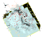 This rather complicated view of the 7.5 km/s isosurface summarizes some key interpretations regarding the configuration of the JDFP and mantle wedge. The red lines are streamlines generated for the isosurface and represent the directions of dip. Note that the dip directions for the main part of the arch region of the JDFP are in the direction of plate convergence (43 mm/y). The streamlines show that the arch dips more steeply on the NNW side and has a shallow dip on the SE side. This results from the effect of the buttress provided by thick crust of Vancouver Island and SW British Columbia. South of the part of the mantle wedge between Seattle and Olympia, the JDFP dips more gently, and may be trying to break away from the more locked part of the arch. This is suggested by the four large intraslab, tensional earthquakes projected at the circles (actual depths were 50-60 km). In addition, the configure of the mantle wedge riding upon the JDFP probably control the main faults in the region, such as the Devils Mt. (DMF), South Whidbey Island (SWF), and Seattle fault zone (SFZ). To look again at a simple view of the isosurface looking obliquely NNW, click here. |
Return to:Subduction Zone Dynamics Intro | PACNW | Earthquake Hazards | Central Region | USGS