Alaska Digital Aeromagnetic Database Description

Alaska Digital Aeromagnetic Database Description
TABLE 1: Alaska Digital Aeromagnetic Database Files
APPENDIX: Linked Information Files
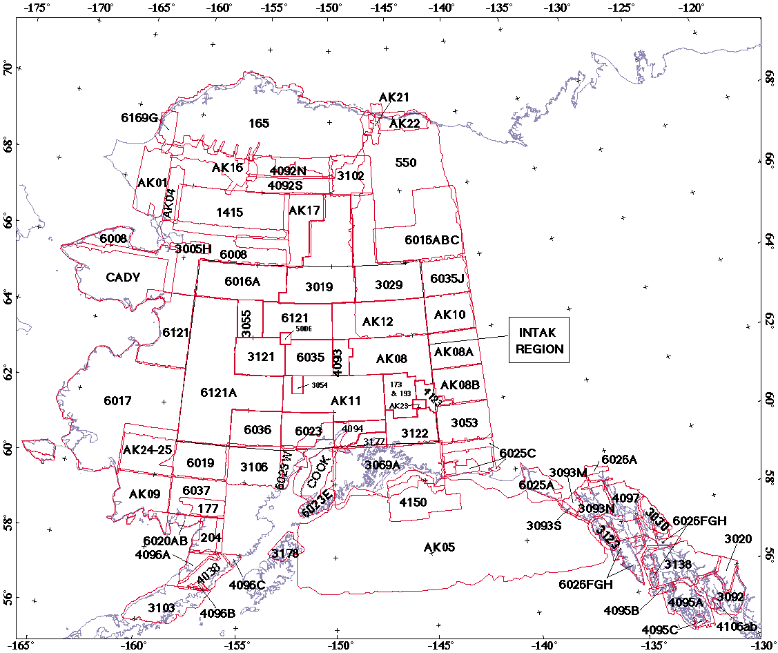
FIGURE 1. Alaska Aeromagnetic Survey Index Map
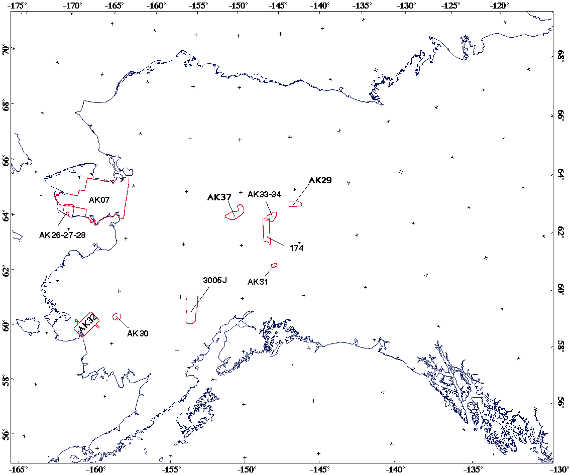
FIGURE 2. Additional Alaska Aeromagnetic Surveys
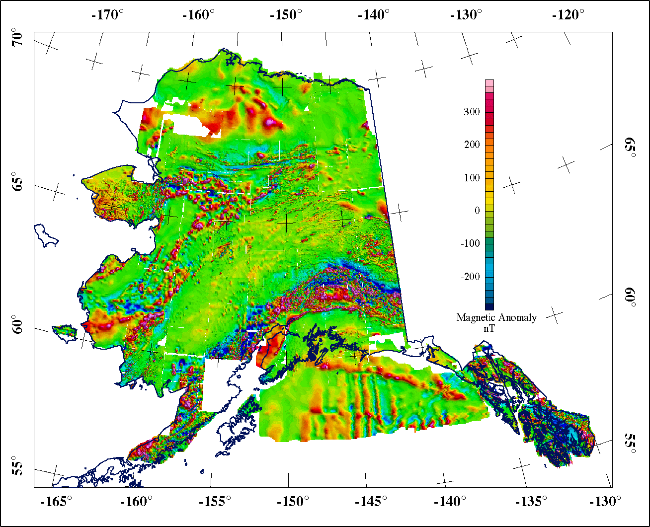
FIGURE 3. Revised Composite Magnetic Anomaly Map of Alaska
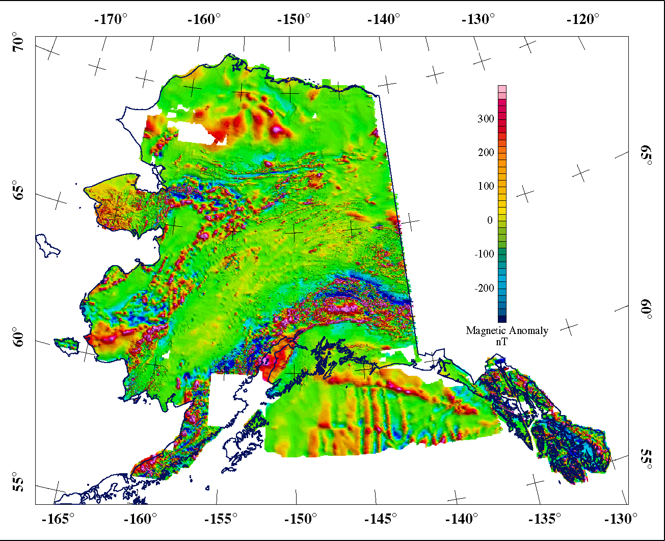
FIGURE 4. Merged Magnetic Anomaly Map of Alaska
Northwest Geophysical Associates, Inc. (NGA) was contracted by the U.S. Geological Survey (USGS) to construct a database containing original aeromagnetic data (in digital form) from surveys, maps and grids for the State of Alaska from existing public-domain magnetic data. This database facilitates the detailed study and interpretation of aeromagnetic data along flightline profiles and allows construction of custom grids for selected regions of Alaska. The database is linked to and reflects the work from the statewide gridded compilation completed under a prior contract. The statewide gridded compilation is also described in Saltus and Simmons (1997) and in Saltus and others (1999a, 1999b).
The database area generally covers the on-shore portion of the State of Alaska and the northern Gulf of Alaska excluding the Aleutian Islands. The area extends from 54°N to 72°N latitude and 129°W to 169°W longitude. The database includes the 85 surveys that were included in the previous statewide gridded compilation. Figure (1) shows the extents of the 85 individual data sets included in the statewide grids.
NGA subcontracted a significant portion of the work described in this report to Paterson, Grant, and Watson Limited (PGW). Prior work by PGW (described in Meyer and Saltus, 1995 and Meyer and others, 1998) for the interior portion of Alaska (INTAK) is included in this present study. The previous PGW project compiled 25 of the 85 surveys included in the statewide grids. PGW also contributed 10 additional data sets that were not included in either of the prior contracts or the statewide grids. These additional data sets are included in the current project in the interest of making the database as complete as possible. Figure (2) shows the location of the additional data sets.
The NGA project team included the following individuals:
The PGW project team included the following individuals:
Rick Saltus was the technical contact person at the USGS. Saltus provided the initial database design, supplied the data and consulted with NGA about technical questions. Pat Hill compiled most of the archival information (metadata) for the individual surveys.
The goal of the project was to make available in an organized format, the original, detailed data used to construct the statewide gridded compilation reported in Saltus and Simmons (1997) and to include recently available surveys not included in the statewide gridded compilation. The database resulting from this project includes both unprocessed and processed data fields tied to the processed grids. The database provides consistent access to basic aeromagnetic data and other airborne survey information for any region of Alaska.
Processed data values were tied to the two statewide aeromagnetic grids reported in Saltus and Simmons (1997). The two grids are the Alaska Composite Grid (AKC) and the Alaska Merged Grid (AKM). The AKC is a one-kilometer grid consisting of all the individual surveys at original altitudes with datum shifts to minimize differences at the boundaries. For the AKM, all of the individual surveys were "draped" at a level of 1,000 feet above the terrain and fit together with seamless joins along the survey boundaries. Saltus and others (1999) presented updated versions of the AKC and the AKM with additional long-wave components removed. For this project, we used the updated versions, which are shown in Figure (3) and Figure (4).
In addition, a new Digital Elevation Model (DEM) for the State of Alaska with a 300-meter cell spacing (Riehle and others, 1997) was used to calculate terrain separation or construct a plausible flight surface when measured values for terrain separation or flight surface were not available in the original survey data.
In general, each survey is represented by a separate database file. However, in some cases, where survey parameters were consistent in adjacent surveys, we combined several surveys into one database file. Combined surveys include:
| Combined Survey Data Files | |
|---|---|
| Database File | Component Surveys |
| 173_193 | 173, 193 |
| 204 | 204A, 204B |
| 6016 | Melozitna, Kateel River |
| 6016abc | 6016a, 6016b, 6016c |
| 6017 | 6017a, 6017b, 6017c, 6017d, 6017e, 6017f, 6017g, 6017h, 6017i, 6017j, 6018 |
| 6020ab | 6020a, 6020b |
| 6023de | 6023d, 6023e |
| 6026fgh | 6026f, 6026g, 6026h |
| 6121ac | 6121a, 6121c |
| ak08 | AK08, AK13 |
| ak14-15 | AK14, AK15 |
| ak21-22 | AK21, AK22 |
| ak33-34 | AK33, AK34 |
Two surveys originally combined as single files were split into multiple files. The Glacier Bay survey (3093) included three overlapping sections flown at very different elevations (15,000 ft., 8,000 ft., 5,000 ft.). Survey 3093 was split into three separate surveys (3093m, 3093n, 3093s) for processing. The Killik River-Chandler Lake survey (4092) included two overlapping sections flown at different elevations (8,000 ft., 4,000 ft.). Survey 4092 was split into two separate surveys (4092n, 4092s) for processing. The splitting and combining of surveys resulted in a total of 90 database files.
For each database file, a linked "information" file contains basic information about the surveys. These information files are described and presented in the appendix. Variations from the general processing scheme are described in the "notes" for each survey.
The raw data for input to the database consisted of three basic data types:
The majority of the surveys (61) were available as digital flightline data (data for which digital records of original flightline data exist). We attempted to recover or construct the standard channels (fields) to be included in the final database for all digital flightline data. For some surveys, some of the standard channels (e.g., MAG_BASE ) were not available and were removed from the individual final database file. The standard channels are:
| Standard Database Channels For Digital Flightline Surveys | |
|---|---|
| Channel Name | Contents |
| Line | Line number |
| FID | Fiducial |
| LAT | Latitude |
| LON | Longitude |
| X | X-coordinate (meters) in the projection listed below |
| Y | Y-coordinate (meters) in the projection listed below |
| HEIGHT | Elevation above ground (meters) if available |
| FLTSURF | Flight surface (meters above sea level) consistent with AKC |
| FLTSURF_M | Flight surface (meters above sea level) consistent with AKM |
| MAG_RAW | Raw magnetics (if available) |
| MAG_BASE | Basemag-corrected magnetics (if available) |
| MAG_DGRF | DGRF-corrected magnetics (if available) |
| MAG_COMP | Composite magnetic value (consistent with AKC) |
| MAG_MERGE | Merged magnetic value (consistent with AKM) |
| USE_FLAG | Used/not-used flag to signal use in AKC |
Two additional channels were included in the database files for a few of the INTAK surveys:
| MAG_IGRF | IGRF-corrected magnetics where DGRF-corrected magnetic were not available |
| MAG_DRAPE | 1,000 ft. draped version of MAG_DGRF or MAG_IGRF |
To preserve as much of the short-wavelength information as possible in the digital flightline data, the following procedures were used to generate the MAG_COMP and the MAG_MERGE channels. Grid values were extracted from the AKC and the AKM grids and temporarily stored in the database as "COMP_GRID" and "MERGE_GRID". The MAG_DGRF channel was "leveled" against the COMP_GRID channel using a DC-shift, 1st-order trend, or 2nd-order polynomial to minimize the difference.
Variable-level continuation was applied to surveys where the data quality justified detailed adjustments and the original survey terrain separation deviated from 1,000 feet. (The AKM has a terrain clearance of 1,000 feet.) The continuation was applied by first gridding the MAG_DGRF channel at the finest grid spacing consistent with the survey specifications (typically to 1/5 of the flightline spacing). Where appropriate, micro-leveling or de-corrugation was applied to these grids. PGW's Compudrape technique was used to adjust the terrain clearance to 1,000 feet. The Compudrape algorithm described by Paterson and others, (1990) is based on the chessboard technique described by Cordell (1985). Values from the continued grids were interpolated at every original data point into a temporary channel MAG_DRAPE.
Either the MAG_DGRF channel, a micro-leveled version of the MAG_DGRF channel, or the MAG_DRAPE channel was subtracted from the MERGE_GRID channel. A non-linear, low-pass filter was applied to the difference to compute the correction to compute the MAG_MERGE channel. The information files list the processing applied to each survey.
Twenty-nine (29) surveys were only available in map form. These surveys were recovered by digitizing contours or digitizing points where contours crossed the flightline path. For these surveys, height above ground (HEIGHT) was derived by subtracting the DEM elevation from the listed flight surface (FLTSURF) if the survey was flown at a constant barometric elevation. If the survey was flown at a constant terrain separation, the flight surface (FLTSURF) was calculated by adding together the DEM elevations and the nominal terrain separation.
Six surveys were only available as digital grids. The original flightline data used to create the grids has been lost. HEIGHT and FLTSURF were constructed in the same manner as for the digitized map data.
The standard channels for digitized map data and grids are:
| Standard Database Channels For Digitized Map Data and Grids | |
|---|---|
| Channel Name | Contents |
| Line (grids) | Line number (for grids but not digitized maps) |
| FID | Fiducial |
| LAT | Latitude |
| LON | Longitude |
| X | X-coordinate (meters) in the projection listed below |
| Y | Y-coordinate (meters) in the projection listed below |
| HEIGHT | Elevation above ground (meters) if available |
| FLTSURF | Flight surface (meters above sea level) consistent with AKC |
| FLTSURF_M | Flight surface (meters above sea level) consistent with AKM |
| MAG_RAW | Raw magnetics (if available) |
| MAG_COMP | Composite magnetic value (consistent with AKC) |
| MAG_MERGE | Merged magnetic value (consistent with AKM) |
| USE_FLAG | Used/not-used flag to signal use in AKC |
Point locations in the database are digitized points along contours or flightlines. For digitized contour map data in the INTAK region, two versions of each survey are included in the deliverables. The second version (with the suffix "g" on the file name) is organized in lines oriented along grid rows. The grids were transposed, if necessary, so that the grid rows are in the original flightline direction.
All processing on these surveys was applied directly to the grids and interpolated back into the database. Where appropriate, grids were de-corrugated. If the processed grids were not more detailed than the AKC and AKM grids (e.g., grid spacing smaller than 1 km), the MAG_COMP and MAG_MERGE channels were interpolated directly from the AKC and AKM grids.
For the more detailed grids, the appropriate datum shift or tilt was applied to the grid to match the AKC grid and the MAG_COMP channel extracted from the shifted grid. A long-wavelength filtered version of the difference between the AKM grid and the MAG_COMP grid was added to MAG_COMP to compute MAG_MERGE.
All of the transformations between latitude, longitude and X,Y coordinates used an Albers conical equal-area projection with the following parameters:
| Projection Specifications | |
|---|---|
| Standard Parallels | 55°N, 65°N |
| Base Parallel | 55°N |
| Scale Factor | 1 |
| Central Meridian | 151°W |
| False Easting | 0 m |
| False Northing | 0 m |
| Semi-major axis of ellipsoid | 6378206.4000 m |
| (Eccentricity)2 of ellipsoid | 0.0067686579973 |
Products of this project included a set of maps at a scale of 1:500,000 covering the project area and four CD-ROMs containing the Alaska Digital Aeromagnetic Database. The maps are color-coded data plots depicting the values and locations of the points in the database. The database contains 90 separate database files and 90 associated information files. Compressed versions of the digital data files are available via ftp download. The CD-ROM version of the report is available from USGS Open-file services (order USGS Open-File Report 99-0502).
The data website and CD-ROM contain a copy of this report, the linked information files, and copies of the database files. The database format is a compressed (using gzip) ASCII, white-space-delimited, XYZ file with the file name extension ".gz". The first eight records of each database file begin with the "/" character and contain comments identifying the channels in the file. If the file is organized into flightlines, a record containing the identifier "Line" and the line number precede each flightline in the file. The identifier "Tie" precedes tie lines. Table (1) lists the 90 database filenames and a summary of the survey specifications. More complete survey specifications are given in the information files in the Appendix (linked to the Project No. field in Table 1).
The additional surveys provided by PGW are segregated in a separate directory on the CD-ROM (EXT-DATA).
Cordell, L., 1985, Applications and problems of analytical continuation of New Mexico aeromagnetic data between arbitrary surfaces of very high relief, in Proceedings of the International Meeting on Potential Fields in Rugged Topography, Bulletin 7, 96-101, Institut de Geophysique de Universite de Lausanne, Lausanne, Switzerland.
Meyer, J. F., Jr., and Saltus, R. W., 1995, Merged aeromagnetic map of interior Alaska: U.S. Geological Survey Map GP-1014, scale 1:500,000, 2 sheets.
Meyer, J. F., Jr., Racic, L. J., and Saltus, R. W., 1998, The compilation and application of aeromagnetic data for hydrocarbon exploration in interior Alaska: in Gibson, R. I. And Millegan, P. S., (eds), Geologic Applications of Gravity and Magnetics - Case Histories, SEG Geophysical Reference Series No. 8, AAPG Studies in Geology, No. 43, published jointly by the Society of Exploration Geophysicists and the American Association of Petroleum Geologists, Tulsa, OK, p. 37-39.
Paterson, N. R., Reford S. W. and Kwan, K. C. H., 1990, Continuation of magnetic data between arbitrary surfaces: Advances and applications. Proceedings of the Society of Exploration Geophysicists, Sixtieth Annual International Meeting, San Francisco, Expanded Abstracts, p. 666-669.
Riehle, J.R., Fleming, M.D., Molnia, B.F., Dover, J.H., Kelley, J.S., Miller, M.L., Nokleberg, W.J., Plafker, George, and Till, A.B., 1997, Digital Shaded-Relief Image of Alaska: U.S. Geological Survey Map I-2585, scale 1:2,500,000, 11 p.
Saltus, R. W., and Simmons, G. C. 1997, Composite and merged aeromagnetic data for Alaska: A Web site for distribution of gridded data and plot files: U.S. Geological Survey Open-File Report 97-520, 15 p. (https://pubs.usgs.gov/of/1997/ofr-97-0520/)
Saltus, R. W., Hudson, T. L., and Connard, G. G., 1999a, A New Magnetic View of Alaska: GSA Today, v. 9 (3), p.1-6.
Saltus, R.W., Hill, P.L., Connard, G.G., Hudson, T.L., and Barnett, A., 1999b, Building a Magnetic View of Alaska: U.S. Geological Survey Open-File Report 99-0418 (web-only report). (https://pubs.usgs.gov/of/1999/ofr-99-0418/)